Hydrosphere & Cryosphere Dynamics: Climate Impact Through Water and Ice
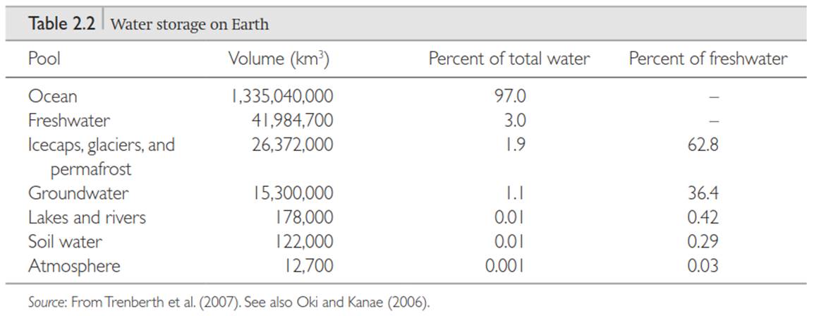
Hydrosphere. The hydrosphere describes the water on Earth held in rivers, lakes, oceans, the ground, and air. Earth holds about 1377 million km3 ofwater. This is an amount that if spread over Earth’s 510 million km2 surface area would be about 2700 m deep. Oceans hold 97 percent of this water (Table 2.2). This is an average depth of about 3700 m spread over the 360 million km2 surface area of oceans. Another 1.9 percent is frozen in polar icecaps, glaciers, and permafrost. Only 1.1 percent of Earth’s water is liquid on land. Rivers, lakes, and wetlands contain 178,000 km3 of water on the surface. Over 15 million km3 of water is below ground. Deep aquifers that comprise groundwater hold most of this water; the soil near the surface holds very little water (122,000 km3). The atmosphere has the least amount of water, about 13.0 km3 or approximately 25 mm of water spread over Earth’s surface area.
Water is an important part of Earth’s climate. The oceans store and transport heat, redistributing the uneven geographic heating of Earth by the Sun. Carbon storage in the oceans regulates atmospheric CO2 concentration. Water vapor is the most important greenhouse gas both in concentration and radiative warming. Water vapor condenses to form clouds, which can precipitate rainfall and which affect the planetary radiation budget by reflecting solar radiation and absorbing and emitting longwave radiation. The latent heat released during condensation provides considerable energy to fuel storms. The hydrologic cycle among the atmosphere, ocean, and land regulates the amount of water vapor in the air. Rates of precipitation and evaporation depend on temperature and other climatic factors so that as climate changes the amount of water vapor in the atmosphere also changes.
Cryosphere. The cryosphere is the frozen portion of Earth including glaciers, sea ice, freshwater ice, snow, and permafrost. Glaciers are large, thick masses of ice accumulated from snowfall. They can be geographically small such as mountain glaciers or extensive ice sheets such as those that cover Greenland and Antarctica. Glaciers are the largest store of freshwater (Table 2.2). The melting of glaciers with a warmer climate contributes to sea level rise. Conversely, sea level was lower during the last glacial maximum some 21,000 years before present when glaciers covered a large portion of North America and Eurasia. Glaciers also affect climate through the planetary energy balance. Glaciers have a much larger albedo than do oceans, soil, or vegetation, which decreases the amount of solar radiation absorbed by the surface and contributes to planetary cooling.
Snow cover and sea ice extent vary seasonally. At its winter maximum, snow covers about 46 million km2 of land in the Northern Hemisphere (Figure 2.2). Sea ice covers 14-16 million km2 in the Arctic Ocean and 17-20 million km2 in the oceans around Antarctica at its seasonal maximum. This sea ice melts during summer to 6-8 million km2 in the Arctic and 3-4 million km2 around Antarctica. Similar to glaciers, snow and sea ice affect planetary energetics through high albedo. Fresh snow, for example, can reflect 80-90 percent of incoming solar radiation compared with 10-20 percent for soil or vegetation.
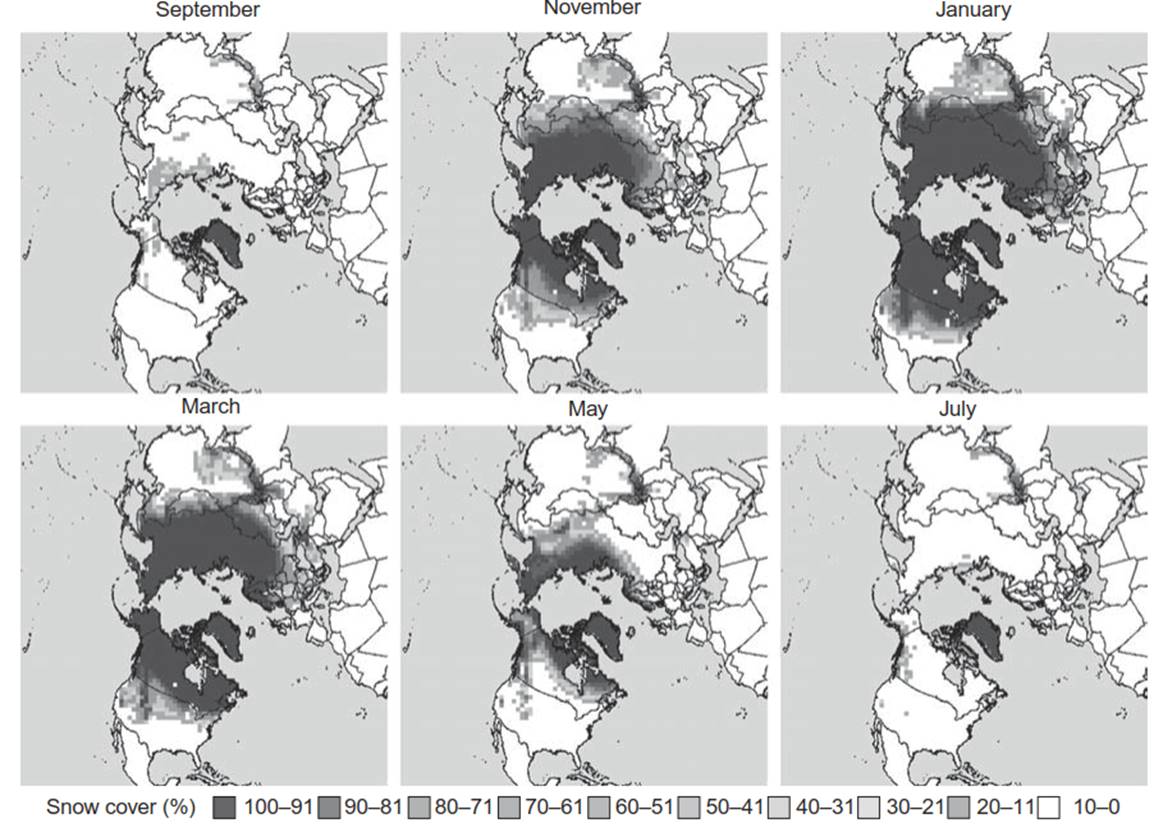
Fig. 2.2. monthly snow cover climatology in the northern hemisphere for the period 1966–1999. maps provided courtesy of David robinson (Global Snow Lab, rutgers University). See color plate section
Permafrost is soil or rock where temperatures remain below freezing for two or more years. It is common throughout the Arctic over vast regions of tundra and boreal forest vegetation. Many factors influence the geographic distribution of permafrost, such as air temperature, snow cover, vegetation cover, the presence of an insulating organic layer, and soil water. Soil temperature and permafrost control ecological and biogeochemical processes at high latitudes. Thawing of permafrost with warmer temperatures alters the biogeography, productivity, and carbon balance of arctic ecosystems. Permafrost restricts infiltration and drainage, leading to wet soils and standing surface water, and the degradation of permafrost impacts runoff of freshwater to the Arctic Ocean.
Permafrost occupies approximately 23 million km2, or 24 percent of land in the Northern Hemisphere (Figure 2.3). Continuous permafrost, where permafrost underlies more than 90 percent of the land, extends over some 11 million km2 including northern regions of Canada, Alaska, and Russia and is widespread throughout Siberia extending to northern China and Mongolia. In more southern locations, permafrost is discontinuous (50-90% of land), sporadic (10-50%), or occurs in isolated patches (<10%) depending on local climate and site factors.
Date added: 2025-05-15; views: 56;