Airlines and Air Transportation. Connectivity
Many of the comments concerning gridlock in America's automobile network apply to air transportation as well. In recent years, fewer and fewer commercial airlines have been able to meet their schedules as a result of air-traffic congestion. A growing number of travelers are demanding air transportation, and it has become increasingly difficult for airlines to meet these increased demands.
The airport currently opening in the Denver area is the first major new airport in the United States in almost twenty years, despite steady increases in air traffic. In Western Europe, air traffic increased by over 7 percent per year throughout the mid- and late 1980s. In order to accommodate this increased volume of traffic, either new airports must be constructed or existing ones must be expanded.
New airport construction is opposed by many local residents who are concerned with ground-traffic congestion, noise, and air pollution. Opposition to airport construction in many suburban localities has prevented municipal authorities from proceeding with airport construction. In general, controversial facilities tend to be located in low-income and minority-dominated areas. The fact that airports require large land areas unavailable in the inner-city has restricted efforts to build new ones in recent years.
The alternative of expanding airport capacity is equally unpalatable. Many of America's major airports, including those in Boston, Washington, Los Angeles, and San Francisco, are located in places where expansion is not possible (Figure 9-7). Some are located along water- ways or in other places where physical conditions prevent expansion. Others are surrounded by densely populated residential neighborhoods and commercial and industrial developments. Ironically, the airport itself is often responsible for attracting development. Office complexes, hotels, and restaurants are often located near airports to accommodate long-distance business travel.
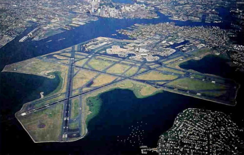
Figure 9-7 Barriers to Airport Expansion. Many of America's major airports (Boston's Logan Airport is shown here) are located in densely populated areas, precluding the possibility of airport expansion. Political and financial support for new airport construction is also lacking in many cases, with the result that airport traffic is increasingly congested
At the global scale, there has long been considerable conflict between states concerning air transportation. Air transport is somewhat more politicized than other modes of international transportation for several reasons. Perhaps most importantly, the technology of air transportation was developed long after the development of the modern nation-state.
According to international law, each state has jurisdiction over airspace above its land area. During periods of international conflict, countries have closed their airspace to hostile states. Many African countries have restricted Israeli and South African aircraft from flying over their territories. As a result, planes are sometimes unable to travel from one airport to another along the route of shortest absolute distance.
Connectivity.Although local competition for access to canals, railroads,and highways has been intense throughout North Americaand Europe, most places are well integrated into nationaland international transportation networks in these regions.The most productive and highly populated regionsbecame connected first, but roads soon were extended toconnect more isolated regions as well. Today, the entirenational economies of the United States. Japan. Australia,and the members of the European Community are integrated into national transportation networks.
In the less developed countries, the integration of places into transportation networks is only partial. Animal-powered carts and bicycles still prevail, not yet having given way to more modern forms of transport. In many less developed countries, modern transportation is confined to major urban centers, port cities, and other more developed places. Modern highways and railroads often stop abruptly as they approach isolated areas, in part because the capital needed to develop and maintain transportation systems is scarce.
Geographers have used mathematical procedures to measure the extent to which national transportation net- works are integrated. A simple measure of integration is the index of connectivity. If each place or region is represented by a point on a graph, the index of connectivity is defined as the ratio of the number of paths connecting the points to the number of points themselves.
The simple example of four points in Figure 9-8 illustrates this concept. There are six possible connections among the four places. With all six connections built and operating, the index reaches its maximum value of 1.50. By contrast, a single road connecting each point renders an index value of 0.75. Clearly, the cost of getting from each point to the others is higher when the network is not fully connected. Higher index values thus represent high degrees of connectivity and network integration.

Figure 9—8 Connectivity. Connectivity indices measure the extent to which a region's transportation network has been developed. Connectivity values often reflect levels of economic development. They are highest in Europe and North America and substantially lower elsewhere
Over the years, studies of the degree of network connectivity have been undertaken by geographers. Not surprisingly, connectivity values are highest in the developed countries. As early as the 1960s, index values approaching the theoretical maximum of 1.5 were reported in France. Belgium. Hungary, and Czechoslovakia. On the other hand, many of the less developed countries continue to report values of less than 1. As construction programs continue in the less developed countries, index values can be expected to increase.
Date added: 2024-03-15; views: 701;