Boston. Beacon Hill. The North End. South Boston. East Boston
Beacon Hill rises north of Boston Common. During the 1600's, the hill served as a beacon station for signaling ships. Since the late 1700's, Beacon Hill has been a fashionable neighborhood with gaslights and narrow, cobblestone streets.
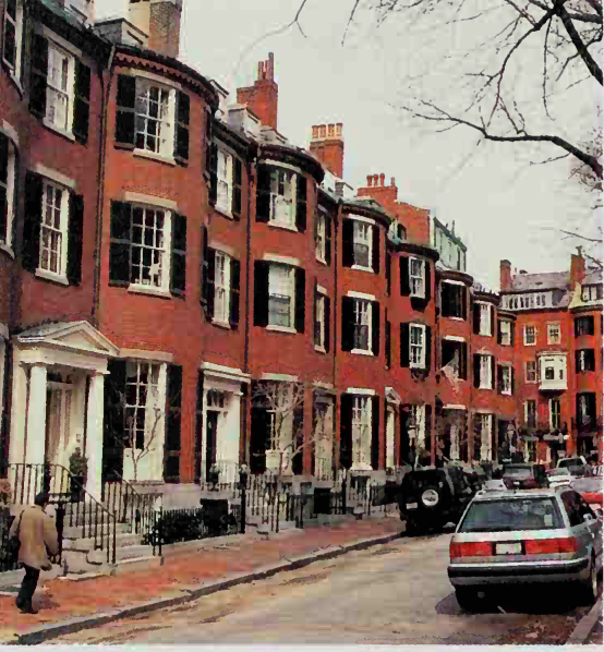
Beacon Hill, with its elegant red-brick houses, has been a fashionable neighborhood since the late 1700's.
Some of Boston's oldest and most distinguished families live in the Beacon Hill neighborhood. Elegant redbrick townhouses surround a lovely park in a charming section called Louisburg Square. The State House, the gold-domed meeting place of the Massachusetts legislature, stands atop the hill on the southern edge of the neighborhood. Brick apartment buildings line the northern slope of the hill.
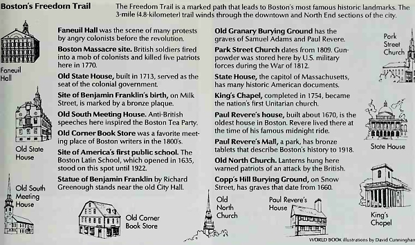
The North End stretches along the east coast of the Shawmut peninsula. Several landmarks on the Freedom Trail, including the Old North Church, where lanterns were hung to warn of a British attack, and the house of the revolutionary leader Paul Revere, are in this area. In colonial times, ships from Europe and Asia docked at the North End. Today, warehouses and other buildings on the wharves are being remodeled into luxurious apartments.
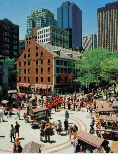
Faneuil Hall Marketplace was developed from the old Quincy, North, and South markets. This lively center in downtown Boston includes food stalls, shops, and restaurants.
Most people in the North End live in four-story brick apartment buildings along narrow, winding streets. Most of the community's residents are of Italian ancestry. Many are Roman Catholics who follow some of the traditions of their ancestors. For example, many Catholic churches celebrate religious holidays with a colorful procession and festival. Money donated to the church is pinned to the garments that clothe a large statue of Jesus Christ or a saint. Several men then carry the statue through the streets, followed by marching bands and worshipers. The festival held after the procession may include carnival rides and folk dancing.
South Boston is a large peninsula in Boston Harbor southeast of the Shawmut peninsula. Many of its residents are people of Irish descent. They feel strong ties to their families and neighborhood and take great pride in their nationality. They affectionately refer to their community as "Southie."
Until the 1940's, South Boston was one of the city's industrial, shipping, and railroad centers. But many factories closed or moved to the suburbs. As a result, unemployment rose and poverty spread. In the 1980's, however, waterfront redevelopment brought new growth. A container shipping terminal opened in 1984, and the renovation of an old pier into the World Trade Center was completed in 1986.
East Boston, another large peninsula in Boston Harbor, is the city's northeastern most section. It is an area of wooden row houses and three-story apartment buildings. Logan International Airport lies on the peninsula's east side.
Charlestown is a hilly, residential section separated from East Boston by Boston Inner Harbor. English colonists founded the town of Charlestown in 1630. Many of these colonists moved on to found Boston several months later. Charlestown became part of Boston in 1873. The U.S.S. Constitution, the famous "Old Ironsides" of the War of 1812, is docked at the Charlestown Navy Yard. Nearby stands a monument commemorating the Battle of Bunker Hill, fought in Charlestown in 1775.
Brighton-Allston lies in northwestern Boston. Many students and families live in apartments and small houses in this neighborhood.
The south side is made up of Roxbury, Dorchester, the South End, Mattapan, and Jamaica Plain. These communities have many old, run-down houses and apartment buildings. The area's many African American and Hispanic churches, community theater companies, and social action groups reflect a strong sense of pride among the neighborhood's people.
Hyde Park and West Roxbury, with their streets of comfortable houses, resemble many New England suburbs. Many of the residents work for the city or state government.
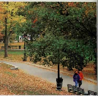
Boston Common, the oldest public park in the United States, dates back to the 1600's. This popular park lies on the western edge of Boston's downtown area.
Metropolitan area. The Boston metropolitan area, or Greater Boston, has nearly 3 ½ million people, which is about half of the population of Massachusetts. About 130 cities and towns in Massachusetts and New Hampshire make up Greater Boston. Boston is by far the largest city in the metropolitan area, but more than 80 percent of the people in the area live outside the city. The city's population is unusually small in relation to the metropolitan area's population. Boston ranks only 20th among U.S. cities in population, but its metropolitan area ranks 7th.
Greater Boston includes many historic cities and towns. Cambridge, on the north bank of the Charles River, is the home of Harvard University. Harvard, founded I in 1636, is the country's oldest institution of higher learning. General George Washington first took command of the Continental Army on the Cambridge Common in 1775. Lexington, which lies northwest of Cambridge, is called "the birthplace of American liberty." In 1775, British troops killed eight minutemen on the Lexington village green in the first battle of the Revolutionary War.
Visitors to nearby Concord can see Minute Man Historical Park and the homes of authors Louisa May Alcott and Ralph Waldo Emerson. In Salem, northeast of Boston, 19 people accused of witchcraft were hanged on Gallows Hill during the 1690's. Today, the city's attractions include its quaint streets and houses, the Salem Witch Museum, and Pioneer Village.
The Boston metropolitan area and nine other metropolitan areas in Massachusetts, New Hampshire, Maine, and Connecticut make up a consolidated metropolitan statistical area called Boston-Worcester-Lawrence.
Date added: 2023-02-04; views: 1034;