Crossing the Atlantic: Exploration and History
Introduction. The Atlantic Ocean is the second-largest ocean after the Pacific and covers a space of 79,776,350 km2, which amounts to about one-fifth of the Earth. The name Atlantic derives from classical mythology and signifies the “sea of Atlas.” Atlas is a Greek Titan who, after losing the war with the Olympians, was condemned to hold up the sky for eternity. The Atlantic stretches from Cape Horn in the west to the Cape of Good Hope and Cape Agulhas in the east. In the north and the south, it borders the polar circles. Due to the intensive transit shipping between Europe and North America, the Atlantic remains the busiest ocean.
Crossing the Atlantic. Crossing the Atlantic occurred in several steps during which the perception of the ocean changed. When the Vikings crossed the Atlantic in the tenth century on their way from Iceland to Greenland, they probably did not realize that they were sailing over an ocean. For the majority of the Europeans, the Pillars of Hercules at the entrance of the Straits of Gibraltar to the Atlantic Ocean remained an insurmountable barrier. Europeans were also informed by Arab geographer Al-Idrisi, who labeled the Atlantic a “sea of perpetual gloom.” Only Christopher Columbus demonstrated that the Atlantic could be mastered. Thereafter, the Europeans understood the Atlantic Ocean to be a maritime space that could be physically overcome and connected via several nodal points. Later on, seafarers, discoverers, and merchants began to realize that ships could sail via the Atlantic to other oceans, such as the Pacific, and even the Indian Ocean.
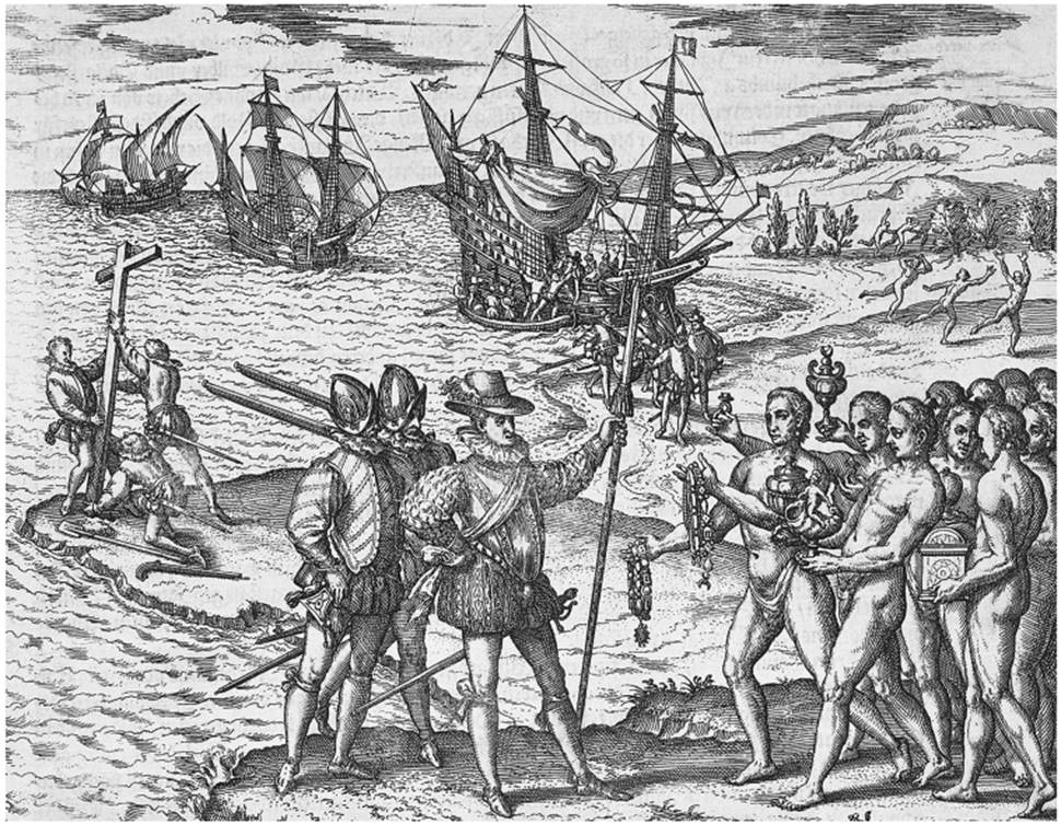
Engraving by Theodor de Bry depicting Christopher Columbus receiving ritual gifts from Cacique Guacanagan on Hispaniola in 1492 (Library of Congress)
Although in antiquity the Phoenicians had sailed into the Atlantic along the African coast, the Canary Islands were only put on the European map during the first half of the fourteenth century, when Genoese sailors Lanzarotto Malocello and Nicoloso da Recco rediscovered these islands. Originally claimed by Portugal, the islands were purchased by the Spanish Crown in 1477 and then colonized and integrated into Castile. The Canaries, where the indigenous population of the Guanches was defeated and Christianized, became a field of exercise for further Spanish expansion to the New World via the Atlantic and were an important stepping-stone for taking on water and provisions. Christopher Columbus used the Canaries as the point of departure for his expedition to find a passage to India in the western direction. Columbus, who had arrived from Palos, left the Canary Islands on September 6, 1492, and landed one month later (October 12, 1492) on the island of Guanahani, which he named San Salvador (today known as Watling Island of the Bahamas). Columbus continued his passage along the coast of Cuba and landed on the island of La Espanola (Hispaniola) on December 6, 1492.
He started his return journey on January 16, 1493, but had to stop due to heavy storms in the Portuguese Azores. After a forced reception by the Portuguese king, he reached Spain on March 15, 1493, and was received together with his “Indians” by the Catholic kings in Barcelona. They sponsored a second journey that lasted from September 1493 to 1496 and took Columbus to the Caribbean, where new islands were discovered. During his third journey (1498-1500) Columbus touched the South American continent at the delta of the Orinoco River. On his last journey (1502-4) Columbus sailed farther south along the Central American coast but did not find a passage farther west and had to return due to shipwrecks, starvation, and mutinies. Disappointed, he died in 1506 in Valladolid. Columbus may have encountered the Americas by happenstance; however, his uncovering of the trade route and easterly wind systems that made round-trip travel between Europe and the “New World” of the Americas possible was no accident.
The exploration of the Atlantic world continued even without Columbus. Amerigo Vespucci’s reports on the northern coasts of South America were so impressive that the new continent bore his name. Giovanni Caboto (John Cabot) on behalf of the English Crown set foot on North America, which he believed was China. Pedro Alvares Cabral discovered Brazil on his way to the Indian Ocean. In 1513, Vasco Nunez de Balboa crossed the Isthmus of Panama and saw the Pacific Ocean for the first time, which he named Mar del Sur. Juan Ponce de Leon explored the coasts of contemporary Florida, while Juan Diaz de Solis reached the Rio de la Plata in 1516. Crucial for further expansion was the delimitation of the spheres of interest between Portugal and Spain.
The Treaty of Tordesillas (1494) divided the world along a meridian approximately 1,200 nautical miles west of the Cape Verde islands. The lands to the east would belong to Portugal, the west to Castile. This demarcation ensured that Portuguese ships could sail down the coast of Africa to India and Brazil. The Spanish Crown commissioned the production of sea maps and globes, and Martin Fernandez de Encisos’s “Suma de geographia” (1519) published sailing directions for many parts of the world, including the Caribbean, for the first time. These and other navigation manuals, such as Martin Cortes’s “Breve compendio de la sphere y del arte de navegar” (1551, 1554), were translated into English and went through many editions.
Any sailor or ship that wanted to cross the Atlantic had to be acquainted with the winds and currents. The Canary or Caribbean Current, for example, fostered the passage to Barbados and the South American mainland, and the Gulf Stream led from the Caribbean via Bermuda to the Azores via the North Atlantic to the North Sea and facilitated shipping to the East. Ports of departure and shipping routes influenced the perception of the Atlantic. From their vantage point, the English, for example, named the North Atlantic the “Western Ocean” or “North Sea,” whereas the South Atlantic was called the “Ethiopian Sea” or “Spanish Sea.” Thus, there was not one single Atlantic, but many. In general, we can at least distinguish three Atlantic Oceans that differed with respect to climate, environment, winds, and currents.
Date added: 2025-08-31; views: 415;