Mapping the Atlantic: A History of Ocean Exploration
Oceanic crossings and increasing access to other oceans dominated Atlantic perceptions for a long time. The usage of the name “Atlantic” itself developed rather slowly. Although, as mentioned before, the ocean’s name has classical roots, it did not appear on maps until much later. For instance, Abraham Ortelius, who was the court cosmographer of Philip II, had extensive access to Spanish maps located in Seville and in his famous atlas divided the Atlantic in 1570 into Mar del Norte and Oceanus Aethiopicus.
In his famous atlas, Lucas Janszoon Waghenaer named the Atlantic Maris Oceani and De Groote Zee Oceanus. During the seventeenth century, many sections of the Atlantic Ocean and its various coasts were inspected and more accurate charts produced. Dampier serves as a case in point, as he reported various problems of the ocean passages, as well as wind patterns, in his publication. In his writings, Dampier was one of the first to employ the name “Atlantic” for the ocean he crisscrossed. The English efforts to provide a degree of safety to Atlantic shipping led to the establishment of the so-called longitude prize by the British Parliament in 1714. It was ultimately John Harrison who would develop a chronometer accurate enough to fetch the desired prize. In France, Jean-Baptiste Colbert had established a hydrographic bureau of AcadSmie Royale des Sciences and commissioned a series of maps called Le Neptune frangois. With this enterprise, he tried to combine two aims: first, to increase the prestige of the French Crown and, second, to apply scientific knowledge for French Atlantic navigation.
In Spain and Portugal, cosmographers at the Casa de la Contratacion in Seville and Casa da India in Lisbon, respectively, actively compiled shipping routes and navigation directions for the South Atlantic. The leading cartographers, however, were the Dutch, who since the sixteenth century had published a series of maps, atlases, and travel reports that circulated widely in Europe. Most significantly, Johan Nieuhof’s maps, engravings, and travel accounts (especially his Voyages and Travels, into Brazil, and the East Indies, 1703) emerged as a virtual multimedia show of the Atlantic world.
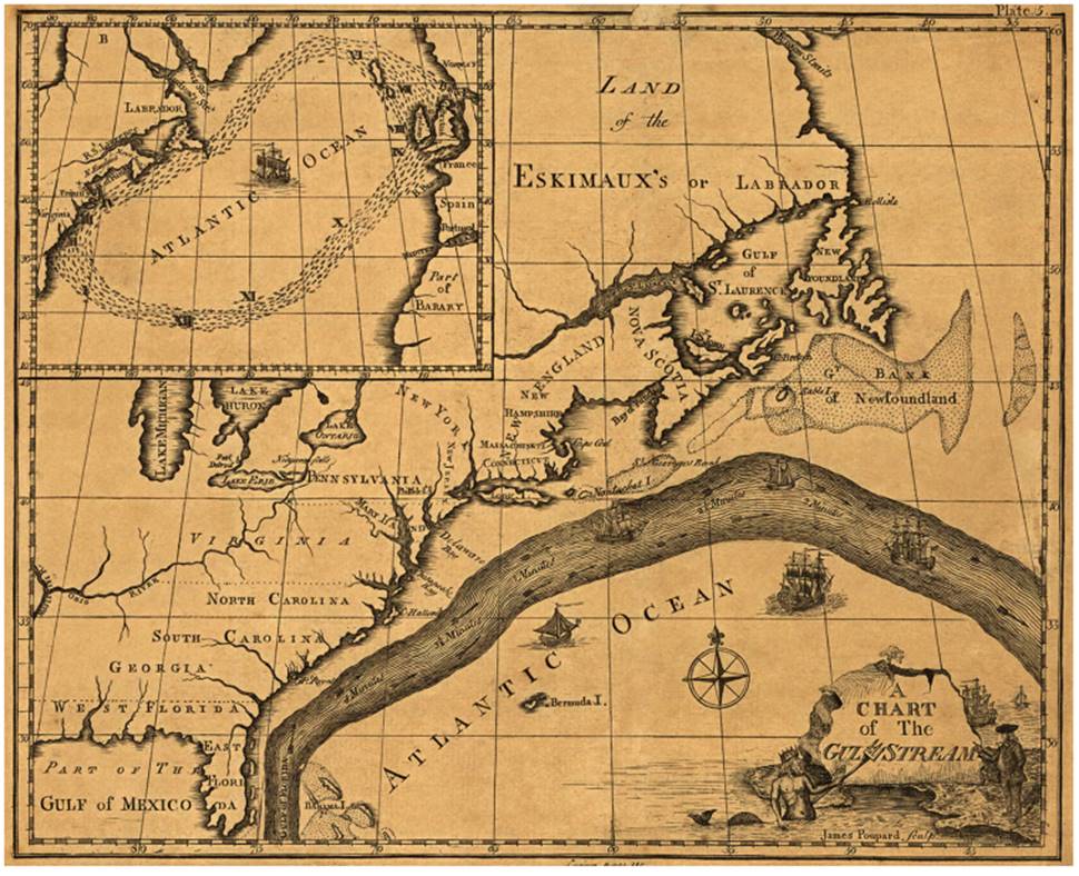
A chart of the Gulf Stream, based on an original by Ben Franklin, American Philosophical Society, 1786. Franklin is credited with mapping the Gulf Stream for the first time and giving it the name by which it is known today (Library of Congress)
British Americans also contributed to the increasing knowledge of the Atlantic world. Benjamin Franklin, for instance, commissioned the charting of the Gulf Stream. Franklin— in his function as deputy postmaster general for the American colonies—investigated the reasons for taking longer time to dispatch mail from England to Boston rather than the other way around.
Franklin inquired with his family members residing in Nantucket and found out through whalers that the Gulf Stream was responsible for speeding up traffic heading east and slowing down the ships sailing from England to New England. Furthermore, the ongoing Anglo-French Wars in North America, especially the Seven Years’ War, brought new attention to Atlantic winds and currents. Britain dispatched maritime surveyors to map strategic coastlines, an enterprise that culminated in the publication of the Atlantic Neptune. Colonel J. F. W Des Barres had initially compiled an atlas of sea charts starting 1774, which was finally published between 1777 and 1780.
Date added: 2025-08-31; views: 423;