Austria. North and East Provinces
I he Danube River flows across a varied area of hills, mountains, and valleys in northeastern Austria. The north and east provinces include Upper Austria, Lower Austria, Vienna, Burgenland, and Styria. The chief cities are Vienna, Graz, and Linz
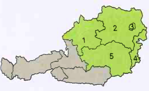
1 Upper Austria, 2 Lower Austria, 3 Vienna, 4 Burgenland, 5 Styria
Upper Austria. Upper Austria, a province in northern Austria, is spanned by the Danube River. Linz, its capital, is Austria's third largest city, and it is the country's most important heavy industrial center. Manufactured items include ball bearings, engineering products, steel, and vehicles.

Wilhering Abbey, right, has an ornate interior with superb frescoes that date from the 1700's. The abbey, which stands near Linz on the banks of the Danube, was founded in 1146.
The province also contains many natural resources. Upper Austria's farmland yields cereals, fruit, potatoes, and sugar beets, while the Alpine foothills support livestock production, and large forests cover the higher elevations. The ancient salt mines in the lake district of Salzkammergut are still productive, and the Danube and Enns rivers generate power for large hydroelectric stations.
Upper Austria's natural beauty also contributes to the economy. Tourists flock to the province's Alpine region, and many people visit the area's spas and health resorts.
Lower Austria and Vienna. Lower Austria, the country's largest province, lies in the northeastern corner of Austria, and completely surrounds the small province of Vienna. Vienna is Austria's capital and largest city as well as its smallest province in area. The two provinces were separated in 1922, but Vienna is still the focal point of both. It is Austria's chief industrial city and a leading European cultural center.
The main towns in Lower Austria include St. Polten (its capital), Wiener Neustadt, and Baden. The province has one of the most varied landscapes in Austria, ranging from high mountains and wooded hills to fertile valleys and grasslands. Due to efficient agricultural methods, the available farmland yields sugar beets, wheat, and wine grapes. Farmers also raise livestock.
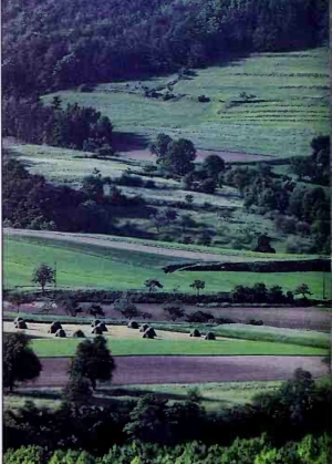
The Wachau Valley, right, stretching along the Danube between Melk and Krems in Lower Austria, is widely considered to be the most beautiful part of the Danube. The Bohemian Forest lies to the northwest, and the Dunkelsteiner Forest to the southeast. The region contains quaint old towns surrounded by vineyards and overlooked by historic castles.
Heavy industry in the region south of the fertile Vienna Basin includes chemical plants, iron and steel works, and textile- and food-processing industries. A number of large hydroelectric power stations lie along the Danube, which runs through the middle of the province. Tourism is also an important industry in Lower Austria, and j resorts in the province's eastern Alpine region attract many visitors.
Burgenland. Burgenland, the most easterly of Austria's provinces, is composed of lands that shifted between Austria to Hungary from the 1400's to 1647, when Hungary took control. Austria acquired the territory from Hungary in 1921, when four regions were united to form Burgenland. However, one of the regions was soon returned to Hungary.
The province's landscape includes Alpine foothills as well as the fringes of the Upper Hungarian Lowlands, a popular vacation area. The picturesque castles and fortresses that line Neusiedler Lake, the lowest point in Austria, also attract many visitors.
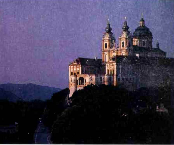
The Benedictine Abbey of Melk, above, stands high above the banks of the Danube River in Lower Austria. Built between 702 and 1738, the abbey occupies the former site of an ancient castle.
Much of the province lies in the Vienna Basin, whose fertile soil helps make Burgenland the country's chief agricultural area. Farmers in the area grow corn, fruit, grapes, sugar beets, and vegetables. Even the industries in the province—sugar refining and canning—reflect its agricultural importance.
Styria. Styria, in the southeast, is Austria's second largest province. The area has a variety of landscapes and climates, ranging from the chilly Alpine regions of the north and central parts of the province to the warm, sunny plains of the south and west. Graz, which lies on the Mur River, is the capital of Styria and Austria's second largest city. The city contains many historic buildings, including the Charles Francis University, which dates from 1586, and a cathedral built in the 1400's.
Grapes, corn, and wheat are grown in Styria's fertile Alpine foothills, and dairy animals graze on the higher Alpine pastures. The timber industry flourishes in the thickly forested mountainous regions. Iron ore deposits mined from the Erzberg (Ore Mountain) near Eisenerz provide raw materials for the area's iron and steel works. Styria's rivers are harnessed as a source of hydroelectric power.
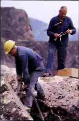
Iron miners have worked in the Erzberg, near Eisenerz in Styria, since the Middle Ages. The Erzberg has one of the largest iron ore deposits in Europe.
Date added: 2023-03-21; views: 948;