Antarctica. Environment and coast
The Antarctic icecap, a thick layer of ice and snow that buries most of Antarctica, is formed by layers of snow that were pressed together over millions of years. High mountain peaks and a few bare rocky areas are the only visible land on the icecap. Underneath the ice, however, Antarctica has mountains, lowlands, and valleys—much like the landforms of other continents. The icecap's thickest parts lie over deep basins that dip far below sea level.
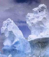
Towering icebergs drift away from the great icecap. Explorers have written vivid descriptions of the color and beauty of icebergs, and compared them to towers, spires, pyramids, cathedrals, and palaces. Icebergs 10 miles (16 kilometers) long are common in the Antarctic
The Antarctic icecap forms the largest body of fresh water or ice in the world. With a volume of 7-1/4 million cubic miles (30 million cubic kilometers), it represents about 70 per cent of the world's fresh water. If the icecap melted, the earth's oceans would rise and flood coastal cities around the world.
The Transantarctic Mountains cross the entire continent. Several ranges make up the Transantarctic chain. Some peaks rise more than 14,000 feet (4,300 meters). Two large gulfs cut into the continent at opposite ends of the mountains, smaller bays indent the coastline, and channels separate offshore is- lands from the mainland.
Broad, flat sheets of the icecap called ice shelves float in several of Antarctica's bays and channels. The largest one is the Ross Ice Shelf, which measures about 2,300 feet (700 meters) thick at its inner edge. In summer, the outer edges of these ice shelves break away and form immense, flat icebergs. Some of these icebergs have measured as much as 5,000 square miles (13,000 square kilometers) in area.
The Transantarctic Mountains divide Antarctica into two natural land regions — East Antarctica and West Antarctica. East Antarctica, more than half the continent, faces the Atlantic and Indian oceans.
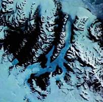
Dry valleys, or ice-free areas, above left, appear where Antarctica's glaciers have retreated and wind prevents snow from collecting. This satellite photograph shows a rocky, ice-free area in Victoria land
This region consists of rocks that are more than 570 million years old. Mountains, valleys, and glaciers line the coast. The central part of East Antarctica is a plateau about 10,000 feet (3,000 meters) above sea level. The South Pole lies on the plateau, at the center of the continent. This pole, also known as the south geographic pole, is the earth's southernmost point, where all lines of longitude meet. East Antarctica also has the south magnetic pole, the southern point indicated by compass needles.
West Antarctica, which borders the Pacific Ocean, contains little of the old rock of East Antarctica. West Antarctica developed later as part of the Ring of Fire, a string of volcanoes that encircles the Pacific Ocean. The region includes several mountain ranges and volcanoes. Vinson Massif, the highest point in Antarctica at 16,864 feet (5,140 meters), stands in the Ellsworth Mountains. Mount Erebus, Antarctica's most active volcano, towers 12,448 feet (3,794 meters) above Ross Island.
Date added: 2023-02-07; views: 861;