Antarctica. Geography and History
Over 2,000 years before Antarctica was discovered, ancient Greek philosophers believed that a continent covered the southern end of the earth. Finally this nearly barren land was sighted in 1820. During the mid-1800's, navigators sailed along its icy coast and learned that it was large enough to be called a continent. In the early 1 900's, inland exploration began, and in 1911 the Norwegian explorer Roald Amundsen reached the continent's best-known location, the South Pole.
Antarctica is larger in area than either Europe or Australia, but it would be the world's smallest continent if it did not have its icecap. This icy layer, which averages approximately 7, 100 feet (2,200 meters) thick, increases Antarctica's surface area by connecting the central land mass with a string of volcanic peaks that form the Antarctic Peninsula, an extension of the Andes Mountains of South America. If the icecap were to melt, these peaks would become separate islands. The icecap also makes Antarctica the highest continent in terms of average elevation.
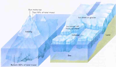
The top of an iceberg is melted by the sun and wind. The bottom, hidden underwater, melts much more slowly and becomes extremely dangerous to ships. Antarctic icebergs form in summer when the outer edges of broad, flat sheets called ice shelves break away. Other icebergs form when a chunk of ice breaks off the lower end of a coastal glacier
The stormy waters of the Atlantic, Indian, and Pacific oceans isolate Antarctica from the other continents. Ships must steer around massive icebergs and break through huge ice sheets to reach the continent. On land, gigantic glaciers move slowly downhill toward the sea. Antarctica is the coldest, iciest region on earth. Temperatures in Antarctica rarely rise above 32° F. (0° C). The world's lowest temperature, - 1 28.6° F. ( -89.2° C), was recorded at Vostok Station in Antarctica on July 21, 1983. Strong, bitter winds also chill the air.
Only a few small plants and insects can survive in Antarctica's dry interior. Its coastal waters, however, are rich in wildlife, and penguins, seals, and flying birds live or nest on the peninsula and offshore islands.
Antarctica is the site of two south poles. The south geographic pole, commonly referred to as the South Pole, is the point where all lines of longitude meet. It lies near the center of the continent. The south magnetic pole is the point indicated by compass needles. This location moves by as much as 5 to 1 miles (8 to 1 kilometers) in a year. In the 1 980's, it was off the coast of Wilkes Land.
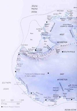
Antarctica lies beneath a layer of ice and snow that measures up to 15,700 feet (4,800 meters) at its thickest points. The Transantarctic Mountains divide the continent, into two regions: East, Antarctica and West Antarctica. The South Pole lies near the center on an icy, windswept plateau. The southern parts of the Atlantic, Indian, and Pacific oceans meet at Antarctica to form a body of water often called the Antarctic Ocean or Southern Ocean
Today, scientists from many countries maintain year-round research stations in Antarctica. Activities on the continent encourage international coopoeration and the sharing of scientific knowledge. Several countries have claimed parts of the continent in the hope of controlling mineral resources found there, but the United States and many other nations refuse to recognize these claims.
Date added: 2023-02-07; views: 1013;