Geomorphology in Archaeology. Geomorphic Mapping
Geomorphology is the study of the evolution of landforms. Analysis of surficial deposits provides much of the evidence for changes in landforms over time. These deposits may be residual materials, formed in place by weathering of underlying formations, or may have been formed elsewhere and then transported by wind, water, or humans to their present site of deposition.
They include both sediments and soils, which are commonly confused in the field although each originates by different processes and each yields different kinds of information. Both geomorphology and surficial deposits are the principal subjects of several other publications1 and will not be covered in great detail here. This book aims to cover in more detail fields that are universally acknowledged to be important for archaeology but are generally ignored in the "geoarchaeology" literature. Those seeking more information on geomorphology and surficial deposits should refer to other publications.
The kind and amount of surficial materials change with the changing land surface and climatic conditions and so offer the best evidence regarding the evolution of the landscape. An understanding of these changes on a site will allow a re-creation of the paleoenvironment at the time of occupation and a modeling of the prehistoric land-use patterns.
Archaeological exploration in an area is facilitated by first pinpointing desirable habitation sites of the time and then targeting these sites for geophysical prospecting. After a site has been discovered, geophysical and geomorphic-sedimentologic information can help develop excavation strategies. Such information commonly allows a better idea of the distribution and nature of buried artifacts and may explain anomalous surficialredistribution of artifacts, for example, by downslope wash or sediment burial.
The first study in a new area proposed for any detailed archaeological work should be geomorphic-surficial geology. It can be carried out in three distinct phases:
1. Geomorphic mapping affords meaningful descriptions of the landforms, drainage patterns, surficial deposits, tectonic features, and any active geomorphological processes.
2. The erosional processes that carved the landforms—including soil formation, sediment removal or deposition, and tectonic uplift—are documented. Typical important indications of landform changes are raised stream terraces, old landslide scars, and changes in sedimentary deposits. Exposures of surficial deposits are studied and cores are collected to gather detailed information on the nature and physical characteristics of the deposits.
3. The landforms, climate, and surficial deposits of today are extrapolated back to reconstruct paleoenvironment and paleoclimate at the time of occupation of the site. The nature and rate of deposition of the sediments will yield valuable data for interpreting these physical changes over time. Information on probable habitation sites and also on the mechanisms of movement of artifacts, including their removal and reburial, will be obtained.
Features such as stream terrace remnants above a broad river floodplain or a deep V-shaped incision cut by the modern stream into older terraces are evidence for a different paleolandscape and perhaps also paleoclimate (figure 2.1).
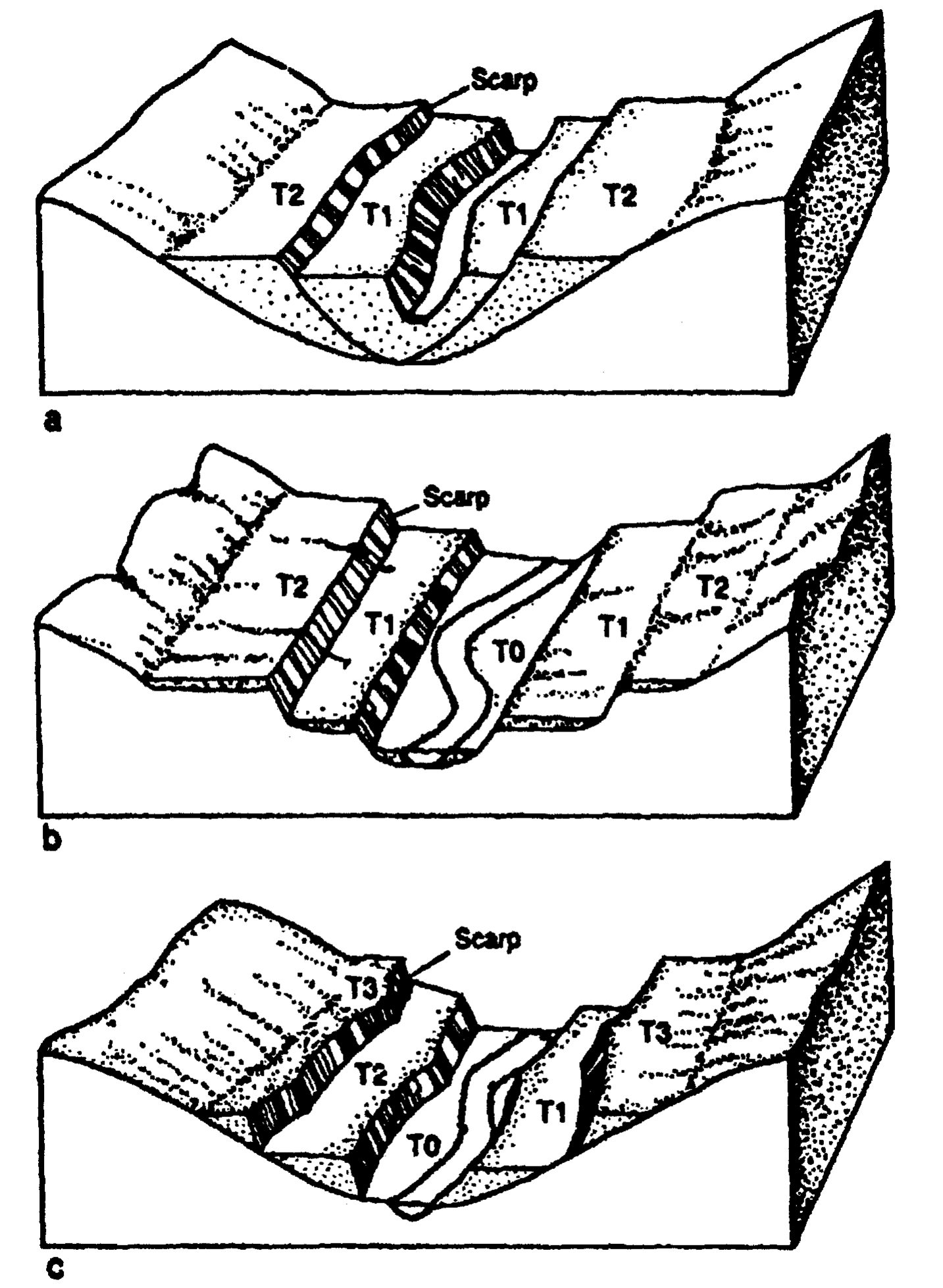
Figure 2.1 Evolution of drainage in Loess Hills of Iowa for the past 8,000 years (modified from Waters, 1992)
The first case suggests ample sediment-carrying ability of the stream through time, implying wet conditions and an ample sediment source. In the second case, a diminished sediment or water source or tectonic uplift could be responsible. Tectonic uplift in the southern Appalachians led to steepening stream gradients and increased the erosion ability of the streams. With the arrival of the Europeans, human-induced processes, specifically cultivation and plowing, accelerated erosion and changed the clear, sediment-free pre-Columbian streams to the muddy, sediment-charged ones of today.
In 1968, in a study of the Nile Valley of ancient Egypt, K. W. Butzer and C. L. Hansen listed the prime issues that should be addressed in a detailed geomorphic study.
1. Initially, geologic-geomorphic relations of the area planned for the archaeological study are mapped in detail.
2. Then an analysis of surficial deposits, especially around valley margins, is made. Certain features, such as a broad alluvial flat, make certain sites better for settlement than others, such as those near landslide zones or on low, active floodplains.
3. Generalizations can be made from this study about the likelihood of site occurrence within the region studied. Whether or not the known preserved sites represent the original density of settlement can then be inferred.
4. Finally, and most important, the paleoenvironmental conditions present at the time of settlement are determined.
From figure 2.1 it can be seen that alluvial flats can be eroded away in a later stream cycle or they can be buried by younger alluvium. If ancient settlements existed on these flats, they, too, may either be eroded and their remains carried away and buried downstream or still be in situ but deeply buried.
Geomorphic Mapping. To produce a geomorphic map, special attention must be paid to the landforms, stream drainage patterns, and the nature of the surficial deposits. This mapping should be an important part of a general geological study that includes a description of the tectonic features and the nature of the bedrock outcroppings. A study of outcrops will give some information on the thickness and nature of the surficial deposits, but, generally, quantitative information can only be obtained from drill cores.
George "Rip" Rapp has recently stated that core drilling is the most underutilized technique in geoarchaeology. Geophysical techniques can also tell much about the nature and thickness of surficial deposits, as well as the distribution and nature of buried archaeological remains.
With this information, the spatial distribution of the landforms can be shown and evidence on how they have changed since the time of occupation can be made more obvious. Depending on the goals of the study, geomorphic mapping can be carried out either in a reconnaissance fashion for a region—that is, covering a large area at a small scale—or in great detail at a large scale to cover a site.
The kind of detail needed for a geomorphic map depends on the setting. In central Alaska, for example, in studies of the late Glacial age (14,000-10,000 BP) careful attention was paid to periglacial features, including glaciofluvial outwash, valley alluvium, and loess. Potential source areas for artifacts that had been redeposited in outwash or alluvium were identified. Testing was then restricted to the identified areas, where the most success was expected in finding evidence of early humans (figure 2.2).
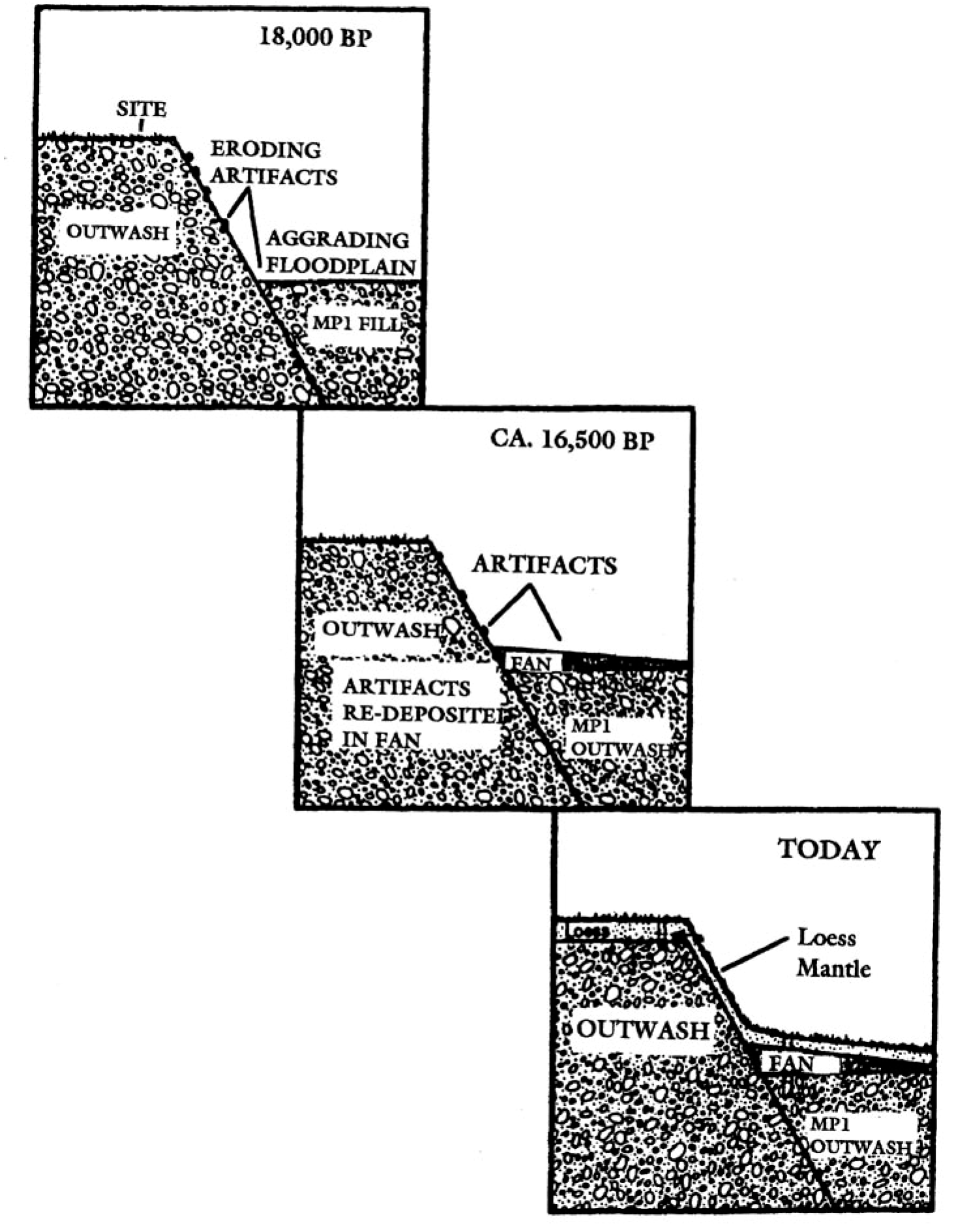
Figure 2.2. Migration of artifacts downslope to redepositional context (modified from Hoffecker, 1988)
A good example of the application of a geomorphic-surficial geology study to a large region with known and prospective archaeological sites is that carried out on the Plain of Drama in northern Greece.5 Figure 2.3 is a map showing the general geomorphic features and surficial deposits. The Plain is floored by limestone and is located in a fault-bounded graben structure that has sunk relative to the surrounding uplands.
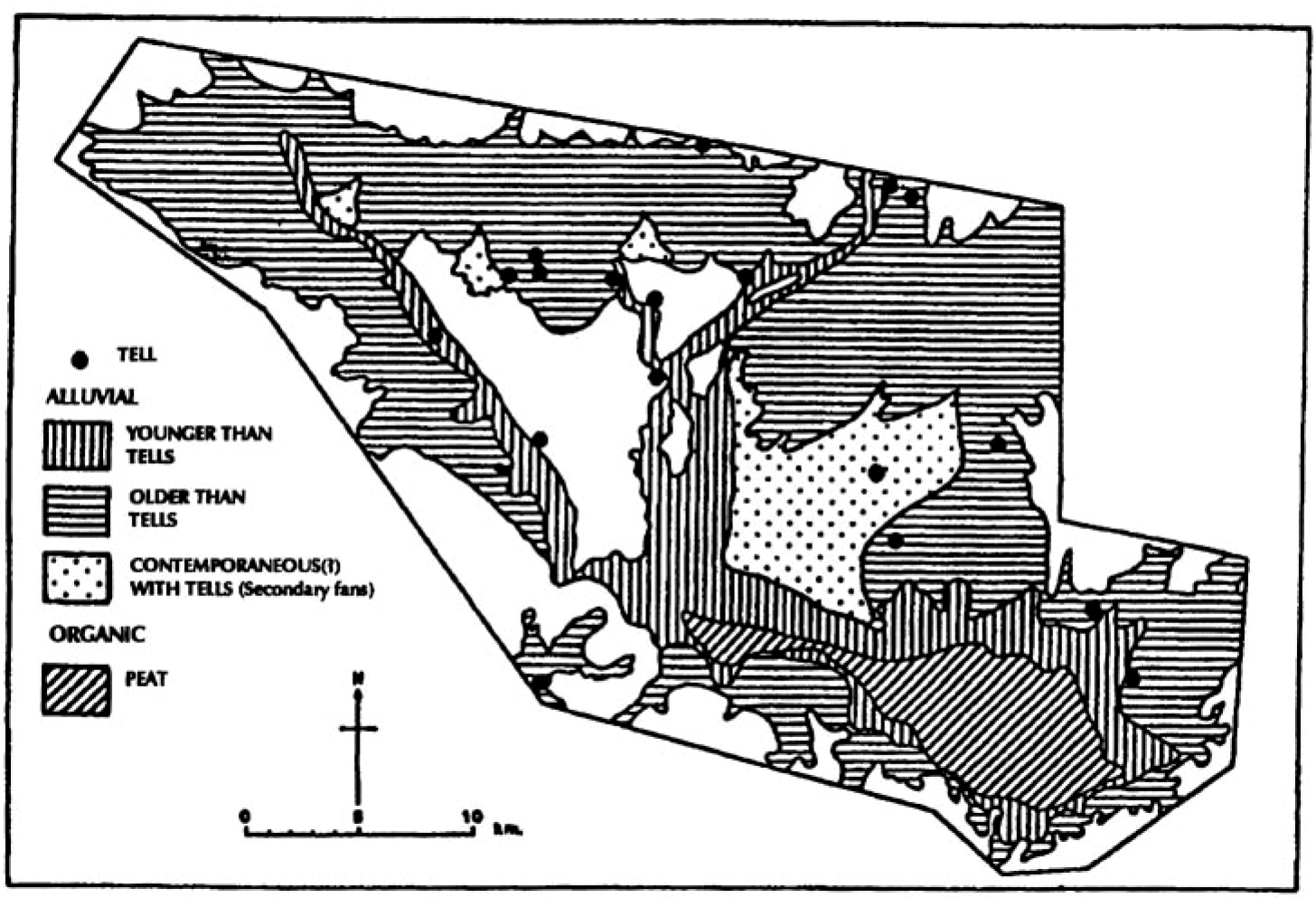
Figure 2.3. Distribution of tells in the Plain of Drama, Greece (modified from Davidson, 1985)
D. A. Davidson distinguished five general landform units: foothills, alluvial fans, other types of alluvium, lowland limestone, and peat and marshland. When the known Neolithic and Bronze Age tells were plotted, it became clear that most were concentrated in or near areas with an older alluvial cover. In this region, the alluvium is derived from weathering of the upland, whose varied rock units would yield a soil rich in elements such as potassium and phosphorus that are necessary for cultivation. In addition, the alluvial areas are better drained and possess better water sources than the lowland limestone, which weathers into a relatively poorly drained, impermeable clay.
Davidson's geomorphic map also provides useful information on the relative ages of alluvial deposits. Over time some sites were eroded away, others were covered by alluvium, and a third group has been exposed at or near the surface. The first group of sites was located on an older alluvium which suffered erosion over time. The second group is probably largely intact but has been buried by a younger alluvium. The third group was fortuitously preserved and lies on an alluvium that has not been eroded since the occupation of the sites. Since the peat and lake deposits are also younger, possibly deposited after Neolithic occupation of the area, they, too, might cover some sites.
Date added: 2023-11-08; views: 642;