Mapping the Globe onto a Flat Surface
A fundamental problem faced by cartographers, or mapmakers, is projecting all or part of the surface of the earth in three dimensions onto a flat, two-dimensional surface. This process requires two steps. First, the globe is reduced to a size equivalent to the map scale. Then, the three-dimensional, reduced globe is projected onto a flat surface using one of the many projection techniques available. The four major projection techniques are conic, cylindrical, planar and oval (Figure B1-2A).
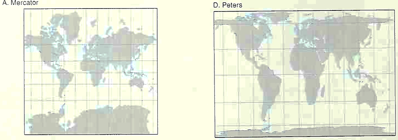
Figure B1-2A. Map Projections. The examples illustrate the various types of map projections used in geography. The choice of a projection is made on the basis of the researcher's specific needs. When one important feature is accurate, others are necessarily distorted
Distortion is inherent in projection. In choosing one projection technique over another, cartographers must decide which type of distortion to eliminate at the expense of other types. Ideally, the projection process would preserve all of the important spatial relationships on the three-dimensional surface of the earth: distance, direction, shape, and area.
During the projection process, however, it is impossible to preserve any one of these without distorting some of the others. The cartographer's choice among these alternatives depends on which spatial relationships are most important for the map's users.
The well-known Mercator projection deflects the spherical surface into a rectangle (Figure B1-2B). The meridians, which in fact converge toward the poles, are drawn on a Mercator projection as if they were parallel to one another. The Mercator projection is useful to sailors because the exact compass distance between any two points can be plotted as a straight line. While linear relationships in the Mercator projection are accurate, this projection has the drawback of areal exaggeration.
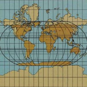
Figure B1-2B. The Mercator Projection. The Mercator projection was first developed in the sixteenth century, at the beginning of the Age of Exploration. It immediately proved useful to sailors in the open ocean, because it preserved the directional relationships between places. Its utility is limited, however, by the fact that the distortion of shapes and land areas is considerable and increases as the poles are approached
The shapes of places are portrayed accurately, but their areas are inflated. Because the meridians do not converge, places located in high latitudes appear larger than they really are. On a world map drawn from the Mercator projection. Greenland appears larger than South America. In fact, the land area of South America is more than three times that of Greenland.
Although many world maps continue to be produced using the Mercator projection, this projection is of little value for purposes other than navigation. In this book, the primary purpose of the maps is to convey information about important distributions. For this purpose, projections that preserve areal relationships and shapes of places are more valuable than those that preserve directional relationships.
Date added: 2023-01-05; views: 989;