Remote Sensing Information Processing
Introduction. With the rapid advance of sensors for remote sensing, including radar, microwave, multispectral, hyperspectral, infrared sensors, and so on the amount of data available has increased dramatically from which detailed or specific information must be extracted.
Information processing, which makes extensive use of powerful computers and techniques in computer science and engineering, has played a key role in remote sensing. In this article, we will review some major topics on information processing, including image processing and segmentation, pattern recognition and neural networks, data and information fusion, knowledge-based system, image mining, image compression, and so on. References (1-5) provide some useful references on information processing in remote sensing.
In remote sensing, the large amount of data makes it necessary to perform some type of transforms that preserve the essential information while considerably reducing the amount of data. In fact, most remote sensing image data are redundant, correlated, and noisy. Transform methods can help in three ways: by effective data representation, effective feature extraction, and effective image compression. Component analysis is key to transform methods. Both principal component analysis and independent component analysis will be examined for remote sensing.
Image Processing and Image Segmentation. The motivation to enhance the noisy images sent back from satellites in the early 1960s has had significant impact on subsequent progress in digital image processing. For example, digital filtering such as Wiener filtering allows us to restore the original image from its noisy versions. Some new image processing, such as wavelet transforms and morphological methods, have been useful in remote sensing images.
One important activity in remote sensing is the speckle reduction of SAR (synthetic aperture radar) images. Speckles appearing in SAR images is caused by the coherent interference of waves reflected from many elementary scatters. The statistics of SAR speckle has been well studied (6). Over a 100 articles have been published on techniques to remove the speckles. One of the most well-known techniques is the Lee’s filter, which makes use of the local statistics (7). More recent studies of the subject are reported in Refs. 8 and 9.
Image restoration in remote sensing is required to remove the effects of atmospheric and other interference, as well as the noises presented by the sensors. A good example is the restoration of images from the Hubble Space Telescope.
Image segmentation attempts to define the regions and boundaries of the regions. Techniques are developed that preserve the edges and smooth out the individual regions. Image segmentation may involve pixel-by-pixel classification, which often requires using pixels of known classification for training. Segmentation may also involve region growing, which is essentially unsupervised. A good example is to extract precisely the lake region of Lake Mulargias on the island of Sardinia in Italy (10).
The original image is shown in Fig. 1a. The segmentation result is shown in Fig. 1b, for which the exact size of the lake can be determined. For land-based remote sensing images, pixel-by-pixel classification allows us to determine precisely the area covered by each crop and to assess the changes from one month to the next during the growing season. Similarly, flood damage can be determined from the satellite images. These examples are among the many applications of image segmentation.
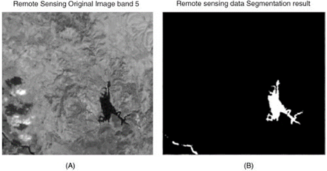
Figure 1. Original image of Lake Mulargias region in Italy (A) and the result of region growing to extract the lake area (B)
Date added: 2024-02-27; views: 713;