Image Mining, Image Compression, and Wavelet Analysis . Component Analysis
To extract certain desired information from a large remote sensing image database, we have the problem of data mining. For remote sensing images, Aksoy et al. (20) describe a probabilistic visual grammar to automatically analyze complex query scenarios using spatial relationships of regions, and to use it for content-based image retrieval and classification.
Their hierarchical scene modeling bridges the gap between feature extraction and semantic interpretation. For image compression of hyperspectral images, Qian et al. (21) provide a survey of major approaches including vector quantization, discrete cosine transform and wavelet transform, and so on.
A more comprehensive survey of remote sensing image compression is provided by Aiazzi et al.(22). Besides its important capability in image compression, wavelet transform has a major application in de-noising SAR images (23). The wavelet analysis of SAR images can also be used for near-real-time ‘‘quick look’’ screening of satellite data, data reduction, and edge linking.
Component Analysis. Transform methods are often employed in remote sensing. A key to the transform methods is the component analysis, which, in general, is the subspace analysis. In remote sensing, component analysis includes the principal component analysis (PCA), curvilinear component analysis (CCA), and independent component analysis (ICA).
The three component analysis methods are different conceptually. PCA is to look for the principal components according to the second-order statistics. CCA performs nonlinear feature space transformation while trying to preserve as much as possible the original data information in the lower-dimensional space see Ref. 25. ICA looks for independent components from the original data assumed to be linearly mixed from several independent sources. Nonlinear PCA that makes use of the higher-order statistical information (26) can provide an improvement over the linear PCA that employs only the second-order covariance information.
ICA is a useful extension of the traditional PCA. Whereas PCA attempts to decorrelate the components in a vector, ICA methods are to make the components as independent as possible. There are currently many approaches available for ICA (27). ICA applications in remote sensing study have become a new topic in recent years. S. Chiang et al. employed ICA in AVIRIS (airborne visible infrared imaging spectrometer) data analysis.
T. Tu used a noise-adjusted version of fast independent component analysis (NAFICA) for unsupervised signature extraction and separation in hyperspectral images (29). With remote sensing in mind, we developed a new (ICA) method that makes use of the higher-order statistics The work is quite different from that of Cardoso (30). We name it the joint cumulant ICA (JC-ICA) algorithm (31,32). It can be implemented efficiently by a neural network. Experimental evidence (31) shows that, for the SAR image pixel classification, a small subset of ICA features perform a few percentage points better than the use of original data or PCA as features.
The significant component images obtained by ICA have less speckle noise and are more informative. Furthermore, for hyperspectral images, ICA can be useful for selecting or reconfiguring spectral bands so that the desired objects in the images may be enhanced (32). Figures. 2 and 3 show, respectively, an original AVIRIS image and the enhanced image using the JC- ICA approach. The latter has more desired details.
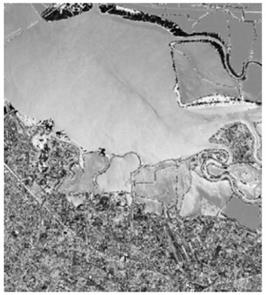
Figure 2. An AVIRIS image of Moffett field
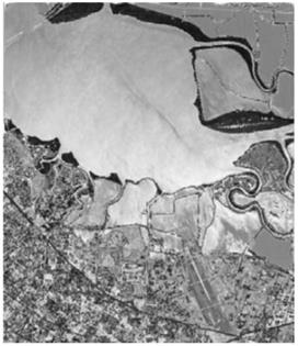
Figure 3. Enhanced image using JC-ICA
Conclusion. In this article, an overview is presented of a number of topics and issues on information processing for remote sensing. One common theme is the effective use of computing power to extract the desired information from the large amount of data. The progress in computer science and engineering certainly presents many new and improved procedures for information processing in remote sensing.
Bibliography:
1. J. A. Richard and X. Jin, Remote sensing digital image analysis, 3rd ed., New York: Springer, 1991.
2. R. A. Schowengerdt, Remote sensing: Models and methods for image processing, New York: Academic Press, 1977.
3. C. H. Chen (ed.), Information processing for remote sensing, Singapore: World Scientific Publishing, 1999.
4. C. H. Chen (ed.), Frontiers of remote sensing information processing, Singapore, World Scientific Publishing, 2003.
5. D. Landgrebe, Signal theory methods in multispectral remote sensing, New York: Wiley, 2003.
6. J. S. Lee, et al., Speckle filtering of synthetic aperture radar images: a review, Remote Sens. Rev., 8: 313-340, 1994.
7. J. S. Lee, Digital image enhancement and noise filtering by use of local statistics, IEEE Trans. Pattern Anal. Machine Intell., 2(2): 165-168, 1980.
8. J. S. Lee, Speckle suppression and analysis for synthetic aperture radar images, Op. Eng.,25(5): 636-643, 1996.
9. J. S. LeeandM. Grunes, Polarimetric SAR speckle filtering and terrain classification-an overview, in C. H. Chen (ed.), Information processing for remote sensing, Singapore: World Scientific Publishing, 1999.
10. P. Ho and C. H. Chen, On the ARMA model based region growing method for extracting lake region in a remote sensing image, SPIE Proc., Sept. 2003
Date added: 2024-02-27; views: 839;