Metropolitan Evolution. Impacts of Transportation Technology on Interurban Growth
The relationship between economic base and urban growth is illustrated with reference to the history of urban development in the United States. During the first two centuries of Anglo-American settlement, the thirteen colonies were ruled by the British. Eager to promote trade with their North American colonies, the British emphasized the development of port cities along the Atlantic Ocean.
The first U. S. census of 1790 identified New York, Philadelphia, and Boston as the largest cities in the newly independent United States. At that time, the ten largest American cities included Gloucester and Salem, both in Massachusetts, and Newport. Rhode Island.
After the American Revolution, the development of the vast North American interior began in earnest. The most cost-effective means of shipping goods and people was by water. Hence, cities on the ocean and inland cities on and near waterways enjoyed considerable locational advantages. The Mississippi River and its tributaries provided a natural interior transportation network. Cities on the Mississippi and the Ohio and other tributaries grew rapidly during the early nineteenth century. Examples include Pittsburgh, Cincinnati, St. Louis, Louisville, and New Orleans.
During the same period, New York surpassed Philadelphia and Boston to become the dominant American metropolis (Figure 10-7). Of the three major colonial cities, only New York was blessed with ready access to the interior. Access from Philadelphia and Boston was restricted by the difficulties of crossing the rugged Appalachian Mountains. On the other hand, the Hudson and Mohawk river valleys provided an easily accessible route between the Atlantic coast and the interior. The construction of the Erie Canal gave New York water connection to the Great Lakes.
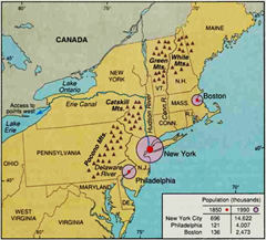
Figure 10—7 The Dominance of New York City. When America became independent in 1776, Philadelphia, New York, and Boston were its three largest cities, and each was roughly equal in population and influence. A century later, New York had become the dominant city of the United States, due partly to its relatively easy access to the burgeoning interior regions
By the middle of the nineteenth century, railroad transportation was faster and more flexible than water transportation. Rapid urban growth in the late nineteenth century was concentrated in railroad-oriented cities, especially those that also had water connection, including Chicago, Kansas City, and Cleveland. In the twentieth century, automobile transportation began to dominate other modes of transportation. Many cities of the southern and western United States, including Los Angeles, Houston, Dallas, Phoenix, and Atlanta, have experienced especially rapid growth in the twentieth century.
Impacts of Transportation Technology on Interurban Growth. Innovations in transportation technology have also influenced the internal development of urban areas. Before railroads were invented, people traveled on foot, on horseback, or in horse-drawn vehicles. Thus most urbanized areas were only a mile or two wide, enabling easy pedestrian access to all parts of the city (Figure 10-8). By the 1880s, however, electric railroads adapted for urban use had become widespread. Streetcars, trolleys, and interurban railroad lines were constructed, and urban development began to spread outward in linear patterns from the center of most cities along these urban railroad lines.
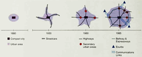
Figure 10—8 The Changing Spatial Form of North American Cities. Over the course of American history, the spatial form of cities has been subject to change. Prior to the development of mechanized transportation, most cities were small. With the development of the railroad, the automobile, and the freeway, cities spread out rapidly and the population densities of city centers declined substantially
The invention of the automobile and its diffusion to the middle and working classes following Henry Ford's invention of the mass-production methods used to make the Model T changed the pattern of urban development again. Areas adjacent to the city but at a distance from railroad lines were developed, and the overall spatial form of most cities became more circular.
The development of freeways following World War II resulted in a considerable spread of metropolitan development across the landscape. Today, many metropolitan areas continue to expand along major freeway routes. Many people now live in rural areas at a considerable distance from city centers, relying on interstate highways to get back and forth from the outlying suburbs of the metropolis.
Date added: 2024-03-20; views: 648;