The development of geological cartography and stratigraphy
Several decades elapsed before Hutton’s theory earned general acceptance, but these were the decades during which geology began to be recognized as a fully fledged and independent subject. It was around 1800 that the science came to be known by its modern name of geology and that it began to be institutionalized.
The world's first geological society—the Geological Society of London—was founded in 1807. and journals devoted to the publication of research in the discipline came into being. For example, the Transactions of the Geological Society of London began publication in 1811 and The American Journal of Science in 1818. Geology was added to the curriculum of many European and American universities, and the first generation of geological textbooks appeared—a generation that included such classics as Robert Bake-well’s An Introduction to Geology (London 1813), Parker Cleavelands An Elementary Treatise on Mineralogy and Geology (Boston 1816) and Carl Friedrich Naumanns Lehrbuch der Geognosie (Leipzig 1850 4).
Nowhere was the new status of geology more evident than in the British Isles where something approaching a geological mania swept through the country between 1800 and 1860. By the latter date geological societies had been founded in Britain not only in London, but in Cornwall, Dublin, Edinburgh, Yorkshire, Manchester, Dudley, Glasgow and Liverpool, Collectors were prepared to pay high prices for good geological specimens, while some geological books were among the literary best sellers of the period. To some extent the popularity of the science in Britain was related to the Industrial Revolution, to which geology was of fundamental importance.
The advent of steam-powered industry created a vigorous demand for coal and iron, Large-scale urban expansion resulted in enormously increased requirements for building stones, brick clays and glass sands. The swollen populations of the new towns and cities needed water supplies and, eventually, huge new cemeteries located upon suitable geological formations. The laying out of the new lines of communication-canals, roads and then railways—created an urgent demand for geological information. Their construction laid bare, in cuttings and tunnels, immense geological sections such as had never before been seen. During the course of the nineteenth century, industrialization occurred in the remainder of Europe and in North America.
The recognition that geology was a key to industrialization, and thus to national prosperity, encouraged many governments to finance the geological surveys necessary to provide inventories of local geological resources. The earliest of all national geological surveys was planned in France in 1822 by the Corps Royal des Mines. Field work started in 1825 and led to the publication in 1841 of a Carte geologique de la France in six sheets at a scale of 1: 500 000. In the British Isles the Geological Survey of England and Wales was established in 1835, under Sir Henry Thomas De La Beche (1796-1855), although ten years earlier the Ordnance Survey had embarked upon an abortive geological survey of Ireland. Across the Atlantic, in 1818.
Governor DeWitt Clinton invited Amos Baton (1776-1842) to give a course of lectures on chemistry and geology to the members of the New York State legislature, and the first actual state survey to be undertaken at public expense was that conducted by Denison Olmsted (1791-1859) in North Carolina in 1823 Within only sixteen years similar surveys had been undertaken in fifteen other states of the Union. Later the Federal government itself financed geological surveying expeditions, such as those of Ferdinand Vandeveer Hayden (1829-87). but it was not until 1879 that the United States Geological Survey was finally established. By 1879 many other national geological surveys had been founded including the Geological Survey of Canada (1841). the survey of India (1850) and the survey of Sweden (1858).
For all these surveys the production of geological maps was a matter of prime importance. Indeed, geologists the world over now accepted that careful field mapping of the Barth’s rocks was the most fundamental task of their science. Fossils were collected and used to identify and date the various formations; the formational limits were traced out in the field and plotted upon topographical base maps: and finally the task was completed by adding colour washes to the map to differentiate the various rock types. This was the great age of both stratigraphy and geological cartography, and the pioneers in these two areas have always been held in high esteem by the geological fraternity.
The most renowned of these pioneers was the English land surveyor and canal engineer William Smith (1769-1839). who has long been known as 'the father of English geology'. In the 1790s Smith discovered that the various strata around Bath could be distinguished by their fossil assemblages, and he soon began to use his discovery to assist him in the construction of a geological map of the whole of England and Wales. Alter some delay, the map was finally published in 1815, at a scale of 1:316 800. and today it is one of the most highly prized classics of the science. In France similar stratigraphical studies were undertaken in the Paris Basin by Georges Cuvier (1769-18 32) and Alexandre Brongniart (1770-1847), their memoir and accompanying map being published in 1811. In the USA the pioneer of geological cartography was William Maclure (1767-1840) whose map depicting the eastern USA was first published m IS09 (Figure 1.9).
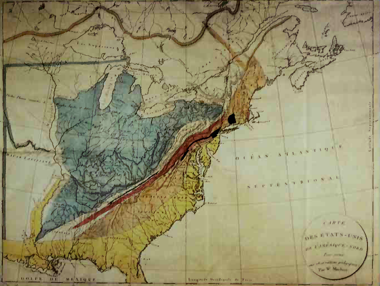
1.9: William Масlure's geological map of the USA first published in 1809. This is the map as it appeared m Journal de physique de chimie. d'histoire naturelle et des arts. Volume 72 (Paris. 1811)
The work of the stratigraphers led gradually to the emergence of the stratigraphical column as know n to modern geology. Naturally it was the sequence of the younger rocks that was deciphered first: those rocks contain most fossils, are least disturbed and. since they rarely form rugged terrain, are freely accessible. By the 1830s a great deal was known about the Upper Palaeozoic and younger rocks, but little sense had as yet been made of the Lower Palaeozoic and older rocks.
They were still just thrown together into an omnibus group styled 'greywackes'. The problem of the greywackes was first tackled seriously by two British geologists: Sir Roderick lmpey Murchison (1792-1871) and Adam Sedgwick (1785-1873). They commenced operations in 1831, with Murchison working down the geological succession on the borders of England and Wales, while Sedgwick tried to work up the succession in North Wales.
In 1835 Murchison proudly consigned his rocks to what he called 'the Silurian system' while Sedgwick, with equal pride, placed his rocks into what he designated 'the Cambrian system'. Further field study revealed that the lower members of Murchison's Silurian system were identical with the highest components of Sedgwick's Cambrian system. Neither geologist was w filing to surrender a part of his system to the other, and there ensued between the two men one of the most bitter of all geological controversies. Not until 1879. after the deaths of the two chief protagonists, was a solution found as a result of a suggestion by Charles Lapworths (1842-1920) that the lower Silurian and the upper Cambrian should both be removed from their respective systems to form a new system, the Ordovician. Lapworth’s proposal completed the basic stratigraphical column as it is now known.
Date added: 2022-12-12; views: 832;