Seasonal Climate Drivers: Solar Cycles, Jet Streams, and Monsoon Systems
Seasons. Changes in solar radiation over the course of a year drive the seasonal heating and cooling of the atmosphere. Air temperatures generally lag by one month compared with solar radiation so that although the least solar radiation is received in December the coldest month is typically January (Figure 5.10). Temperatures generally follow latitudinal bands. In the Northern Hemisphere, which is experiencing winter, the poleward temperature gradient is particularly strong. July is typically the warmest month. In July, the Northern Hemisphere poleward temperature gradient weakens, because the Sun’s declination is north of the equator and the latitudinal gradient in solar radiation diminishes.
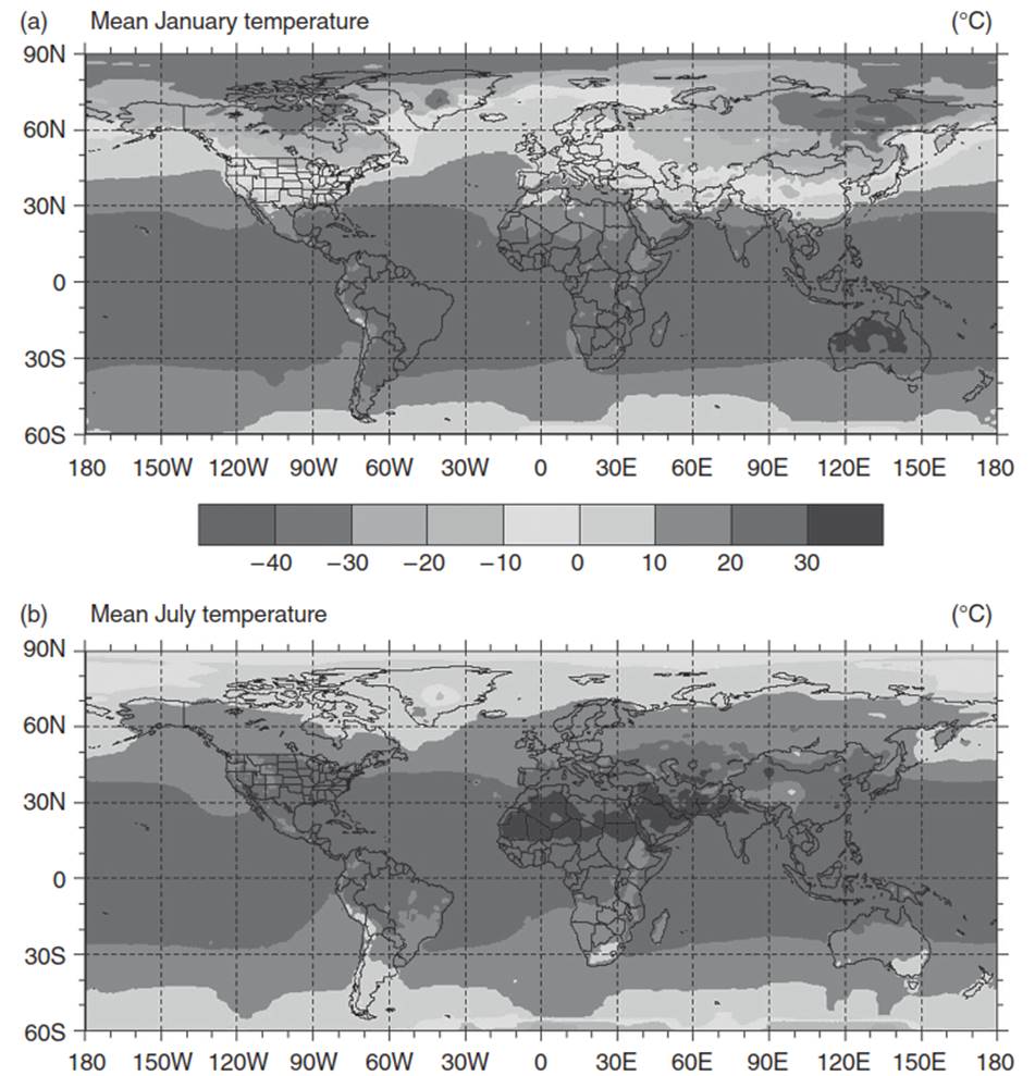
Fig. 5.10. Mean air temperature for (a) January and (b) July. Data provided by the national Center for Atmospheric research (Boulder, Colorado). See color plate section
The tropics and subtropics, between latitudes 30° S and 30° N, show the least seasonal variation in temperatures. Temperatures in this region are generally between 20°C and 30°C throughout the year. In contrast, middle and high latitudes have pronounced seasons, with temperatures below freezing in winter and generally from 10°C to 20°C in summer.
The moderating influence of oceans on temperature is evident in Figure 5.10. This is particularly clear in January, when temperatures are colder in the interior regions of North America and Eurasia than at similar latitudes near oceans. Moreover, the continents have a larger seasonal temperature range than corresponding oceans. For example, while the seasonal temperature range in interior North America is about 25°C, the temperature range in the North Atlantic Ocean is only about 10°C. Land has a much lower heat capacity than water so that the continents cool faster than oceans in winter and warm more in summer.
As a result of seasonal changes in solar radiation and temperature, the major surface high and low pressure systems migrate to different locations. In winter, two large subarctic low pressure systems center in the northern regions of the Atlantic and Pacific Oceans - the Icelandic and Aleutian lows, respectively (Figure 5.5). Two high pressure systems - the Bermuda high in the Atlantic and the Pacific high off the California coast - develop in subtropical latitudes near 30° N. High pressure cells form over Asia and North America due to the intense cooling of land. During summer, land warms and low pressure systems replace the continental high pressure cells. The Icelandic and Aleutian lows, so strong in winter, are barely noticeable. Instead, the subtropical Bermuda and Pacific highs dominate.
Seasonal changes in solar radiation and temperature also alter winds aloft. Winds can be partitioned into their south-to-north (meridional) and west-to-east (zonal) components. Figure 5.11 shows the zonal wind as a function of height. The strong westerly winds in the upper atmosphere between 10 and 15 km aloft in the middle latitudes of each hemisphere are the jet streams. They locate along the fronts that separate cold polar air from warm tropical air, where the horizontal temperature and pressure gradients are greatest. The subtropical jet stream is centered at latitude 30°, near the polar extremity of the tropical cell. A second jet, called the polar jet, is located further poleward at the edge of the polar cell. The sharp poleward contrast in temperature produces a rapid horizontal pressure gradient that intensifies winds along the front. Because the poleward temperature gradient is strongest in winter and weakest in summer, the jet streams show seasonal variation. Winds are strongest and dip further from the poles in winter. The jets weaken in summer and migrate to higher latitudes.
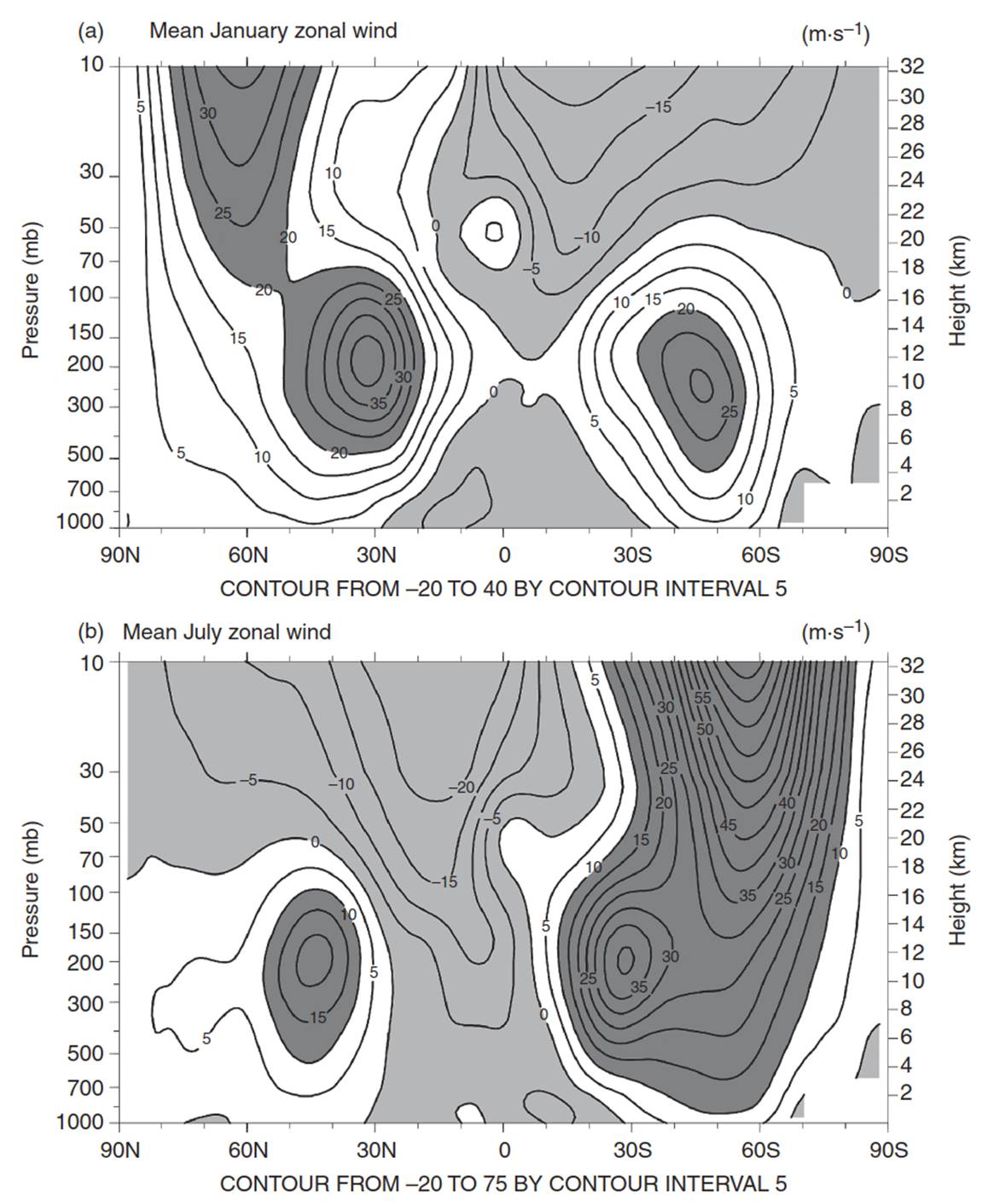
Fig. 5.11. Mean monthly zonal (west-to-east) wind as a function of latitude and height for (a) January and (b) July. Height is in pressure (millibars) on the left axis and altitude (kilometers) on the right axis. one millibar equals 1 hPa. East-to-west winds (negative zonal wind) are lightly shaded. Strong westerly winds are darkly shaded. Winds are averaged around the world, from longitude 180° W to 180° e. As a result, the jet streams are seen as single solid cores. Data provided by the national Center for Atmospheric research (Boulder, Colorado)
These seasonal changes in surface pressure and atmospheric circulation drive seasonal changes in precipitation (Figure 5.12). The intertropical convergence zone, where the convergence of the trade winds produces rising motion and heavy rainfall, migrates from south of the equator in boreal winter (austral summer) to north of the equator in boreal summer (austral winter). For example, tropical regions of South America and Africa between the equator and latitude 10° S receive more rainfall from November to April than from May to October. In contrast, the region north of the equator receives the most rainfall in the boreal summer season.
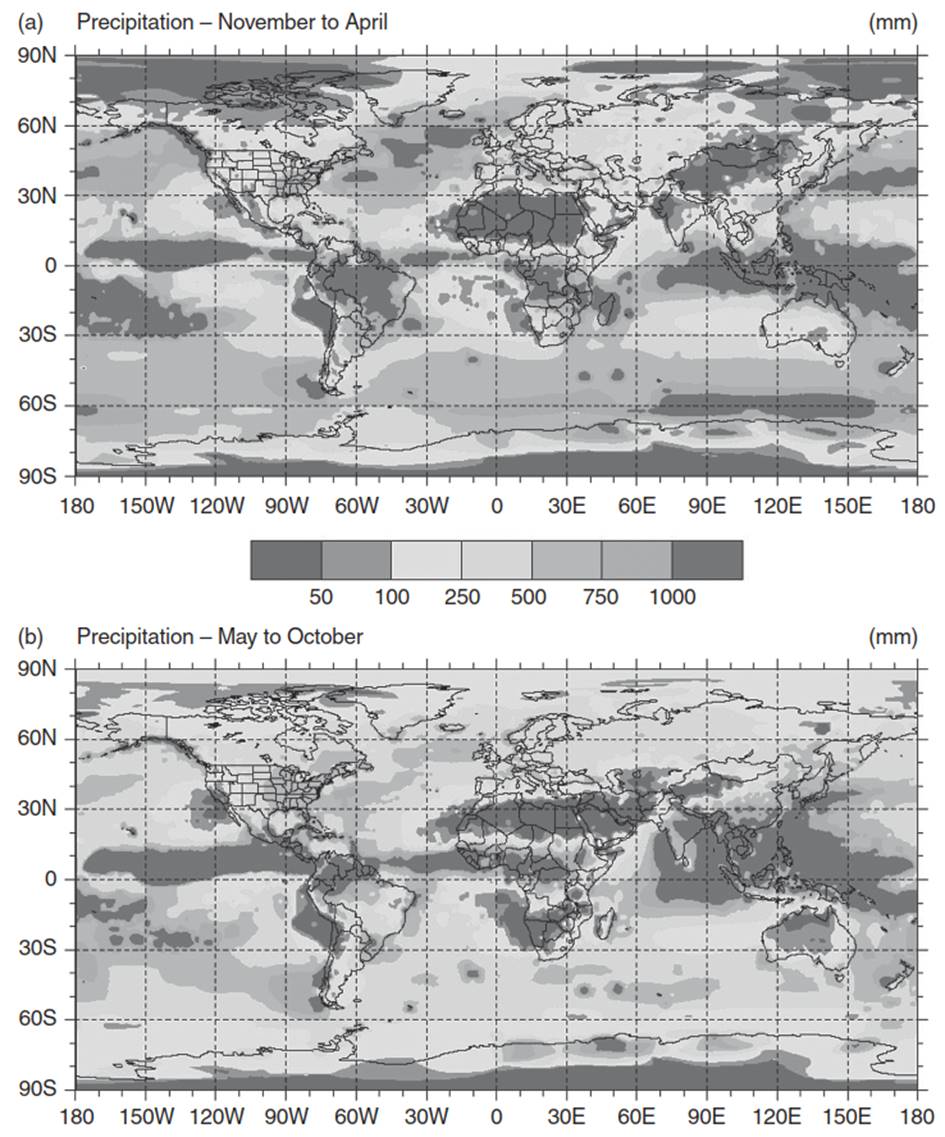
Fig. 5.12. Precipitation for (a) November–April and (b) May–October. Data provided by the national Center for Atmospheric research (Boulder, Colorado). See color plate section
Monsoons are a prominent large-scale seasonal atmospheric circulation. They arise from the differential heat capacity of land and water and the resulting thermal differences between continents and oceans. Land heats and cools faster than water. In winter, the continents are colder than oceans and have high surface pressure. Oceans are warmer and have low surface pressure. The high pressure over land drives air offshore towards the oceans. The opposite atmospheric circulation - onshore winds - occurs in summer when the continents warm, the surface low pressure intensifies, and moist air flows from oceans (high surface pressure) to warmer land (low surface pressure). Such monsoons can be seen in Asia, Africa, Australia, and southwest North America and bring heavy seasonal rain (Figure 5.5).
Date added: 2025-05-15; views: 492;