North Atlantic Oscillation. Other Modes of Variability
The seesaw behavior of El Nino and La Nina is a naturally recurring pattern of climate variability. A similar type of oscillation occurs in the North Atlantic in winter, where north-to-south variation in surface pressure affects climate in a pattern called the North Atlantic Oscillation (Hurrell et al. 2003) . During summer, a strong subtropical high pressure system centered near the Azores dominates much of the North Atlantic (Figure 5.5). The Azores high weakens during winter, and the Icelandic low dominates the North Atlantic. A weaker subtropical high migrates towards the equator. The Icelandic low and Azores high drive the westerly flow of air across the North Atlantic and guide storms onto Europe.
The meridional gradient in winter surface pressure between Iceland and the Azores changes over time, with great consequences for eastern North America, Europe, and northern Asia. The normalized difference in surface pressure between Iceland and some southerly location (e.g., Lisbon, Portugal) is an index of the North Atlantic Oscillation. In the positive phase, pressure is lower than normal over the region of the Icelandic low and higher than normal across the subtropical Atlantic. Positive values are associated with stronger than average westerlies across the North Atlantic. In the negative phase, both pressure centers are weakened.
The climatic effects of the North Atlantic Oscillation are most pronounced in winter and are seen in temperature (Figure 7.10) and precipitation (Figure 7.11) . During the positive phase, stronger than average middle latitude westerlies cause more frequent and stronger winter storms to cross the North Atlantic on a more northerly track. Counterclockwise flow around the deepened Icelandic low drives cold polar air onto Greenland and Labrador, where temperature and precipitation are below normal. Strong westerlies force maritime air onto northern Europe, where winters are warmer and wetter than normal. Clockwise flow around the strengthened subtropical high forces warm subtropical air into eastern United States (mild, wet winter with fewer snow days) and cool northerly air into the Mediterranean (below normal-precipitation). The reverse patterns occur in the negative phase. Storms are less frequent and weaker and cross the Atlantic on a more zonal track. The Mediterranean has wetter than normal conditions while winter across northern Europe is colder and drier than normal. Winter is colder than normal across eastern United States with more snow storms while Greenland experiences milder than normal temperature.
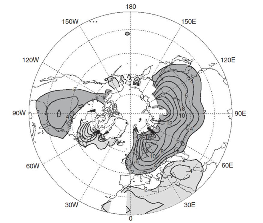
Fig. 7.10. Change in mean winter (December–march) surface temperature (× 0.1°C) due to a unit increase in the north atlantic Oscillation index. Contours are in 0.2°C increments with contours > 0.2°C darkly shaded and those < -0.2°C lightly shaded. Reproduced from Hurrell et al. (2003)
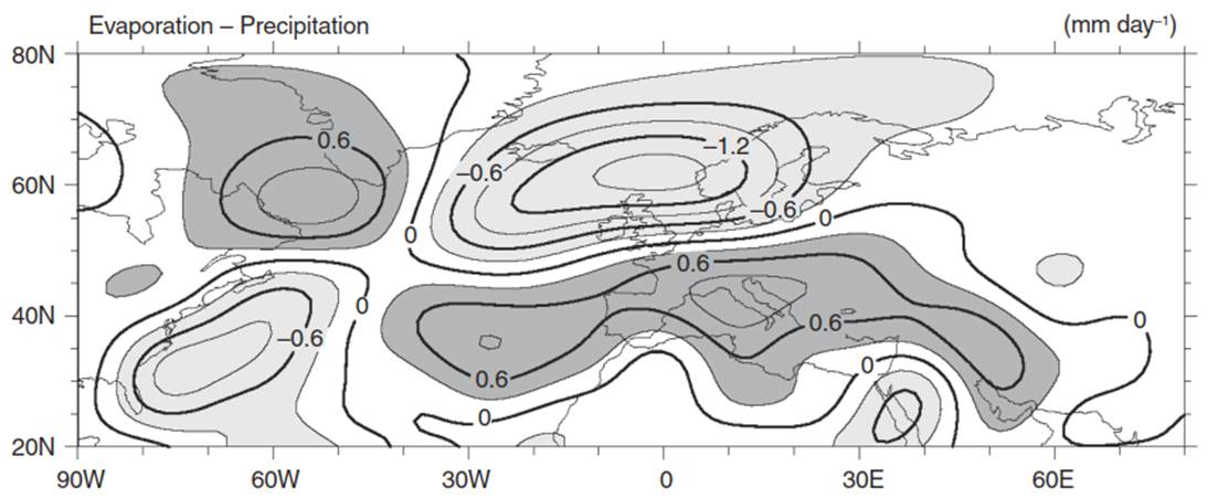
Fig. 7.11. Difference in mean winter (December–march) evaporation minus precipitation (E-P) between years with high and low north atlantic Oscillation index. Contours are in 0.3 mm per day increments with contours > 0.3 mm day-1 (dry conditions) darkly shaded and those < -0.3 mm day-1 (wet conditions) lightly shaded. Reproduced from Hurrell et al. (2003)
The North Atlantic Oscillation is observed in historical records over several centuries (Hurrell and van Loon 1997; Jones et al. 1997, 2003; Cook 2003; Masson-Delmotte et al. 2013). Figure 7.12 shows a time series of the NAO index since 1864. The period 1900-1930 had predominantly positive index values while the 1960s were characterized by negative index values. The North Atlantic switched again to positive index during the 1980s and 1990s. The upward trend in the NAO index and its relationship with the observed warming of Northern Hemisphere surface temperature over the same period is the subject of considerable research (Hurrell 1995 ; Hurrell et al. 2003).
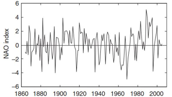
Fig. 7.12. Winter (December–march) index of the North Atlantic Oscillation (NAO) from 1864 to 2005 based on the difference in normalized sea level pressure between lisbon, Portugal, and Stykkisholmur/Reykjavik, iceland (Hurrell 1995; Hurrell et al. 2003). Data provided by James Hurrell (national Center for atmospheric Research, boulder, Colorado)
Other Modes of Variability. The ENSO and NAO are two of many modes of interannual climate variability, and they are second only to the change in seasons in terms of their impact on global climate. Other modes of variability occur, and these climate fluctuations impact marine and terrestrial ecosystems worldwide (Stenseth et al. 2002 ).
The Arctic Oscillation (AO), also known as the Northern Annular Mode (NAM), is characterized by winds moving counterclockwise around the Arctic. In its positive phase, surface pressure in polar regions is lower than normal. The upper- level westerly winds are strong and restrict cold arctic air to polar regions. Much of the United States and northern Eurasia experience above-normal temperatures. These winds weaken during the negative phase of the AO, when pressure is higher than normal in polar regions. The weaker circumpolar circulation allows cold arctic air masses to move southward. Winters are colder and stormier than normal.
The Atlantic Multi-decadal Oscillation (AMO) is another mode of variability occurring in the North Atlantic Ocean. It is characterized by a coherent pattern of warm or cool sea surface temperature anomalies with a period of several decades. The AMO affects temperature and precipitation over North America and Europe.
The Pacific Decadal Oscillation (PDO) is a long-lived (20-30 years) ENSO-like event in the Pacific Ocean. Its phases are characterized by warm or cool ocean temperature anomalies, and the effects of the PDO on climate are seen primarily in the North Pacific and in North America. The positive phase is characterized by anomalously cool sea surface temperatures in the North Pacific and warm ocean temperatures along the Pacific Coast. A deeper wintertime Aleutian low pushes warm, humid air onto the Pacific Northwest, Alaska, and British Columbia, which experience above-normal temperatures. Southeastern United States has below-normal winter temperatures. These patterns are reversed in the negative phase.
Date added: 2025-05-15; views: 531;