Understanding River Deltas: Formation, Types, and Environmental Significance
River deltas represent low-lying, flat alluvial deposits that form at the mouths of streams and rivers, creating broad triangular or irregularly shaped areas extending into bays, oceans, or lakes. These coastal landforms are characterized by multiple distributaries branching from the main river channel and often extend considerable distances underwater. As highly sensitive coastal environments, deltas face significant vulnerability to rising sea levels and various human activities. The presence of rich oil deposits beneath these fragile ecosystems creates a complex balance between meeting global energy demands through extraction and preserving the ecological integrity of delta environments.
Sedimentary Processes and Delta Formation. When a river or stream enters a relatively still body of water such as a lake or ocean, its velocity decreases dramatically, reducing its capacity to hold sediment in suspension. This sudden energy loss causes the stream to deposit its sediment load, forming what is known as a delta. The ancient Greek historian Herodotus first applied the term "delta" in the fifth century B.C.E. to describe the triangular alluvial deposits at the Nile River mouth. The deposition process follows a predictable pattern where the stream drops coarser material first, followed by progressively finer sediments farther from the shoreline, creating a distinctive sedimentary sequence.
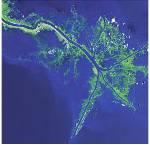
False-color composite of Mississippi River delta from ASTER instrument on NASA’s Terra satellite, May 24, 2001 (USGS EROS Data Center Satellite Systems Branch as part of “Earth as Art II” image series, NASA)
In 1890, American geologist Grover Karl Gilbert conducted groundbreaking research on small deltas in ancient Lake Bonneville across Utah, Idaho, and Nevada. Gilbert recognized that the deposition of finer-grained material at greater distances from the shoreline created a characteristic vertical sequence in delta deposits. This sequence consists of three primary components: the foreset layer, which exhibits graded bedding from coarse nearshore sediments to fine offshore materials; the bottomset layer, composed of the finest sediments deposited farthest from the shore; and the topset layers, which form as the stream extends its length and builds new deposits atop the existing structure. Topset beds encompass various subaqueous and subaerial subenvironments that develop as the delta progrades seaward.
Global Distribution and Morphological Diversity. Major river systems worldwide, including the Mississippi, Nile, and Ganges, have constructed enormous deltas, each exhibiting unique characteristics shaped by local conditions. The morphology and size of deltas depend on multiple factors: the volume of sediment deposited, wave energy, tidal action, climate conditions, and the tectonic stability of the coastal region. Most deltas develop along passive or trailing continental margins, with few examples found along convergent boundaries, except for notable cases like the Copper River in Alaska and the Fraser River in British Columbia. This distribution pattern reflects the tendency of rivers on passive margins to be longer, drain larger areas of easily eroded soil, and carry substantial sediment loads, whereas rivers along active margins are typically shorter, cut through bedrock, and yield comparatively smaller sediment loads.
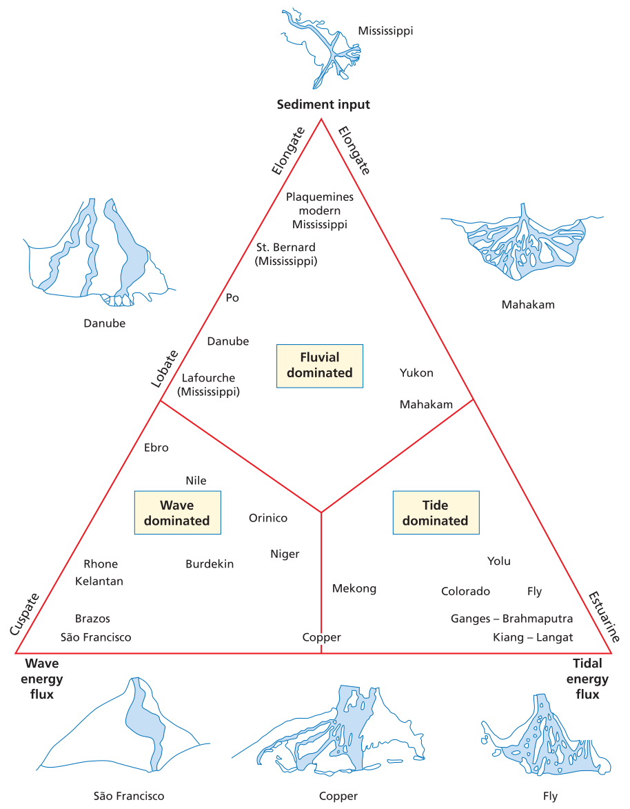
Diagram illustrating different types of deltas formed as a result of different relative influence of sediment supply, tidal energy flux, and wave energy flux. The shapes of deltas characteristic of each are shown on the edges of the diagram, and names of other deltas are plotted in the space inside the diagram, in positions that reflect the relative strength of each component for each delta.
Geological History and Sea-Level Influence. The majority of modern deltas are geologically young features that formed following the melting of glaciers between 18,000 and 10,000 years ago, when sea levels rose onto continental shelves. During the last glacial maximum, which characterized much of the period from 2.5 million years ago until approximately 18,000 years ago, sea levels stood about 395 feet (120 meters) lower than present levels. Rivers during this period eroded canyons across exposed continental shelves and transported sediment directly to deep ocean basins. As glaciers melted and sea levels rose onto broad continental shelves, adequate space became available for the accumulation of thick delta sediments. While active delta surfaces are generally younger than 18,000 years, many deltas contain older, deeper components that formed during previous interglacial periods when sea levels were similarly high.
The rate of sea-level rise played a crucial role in delta formation. During initial rapid melting phases, river mouths migrated inland too quickly for deltas to develop substantially. Approximately 6,000 years ago, the rate of sea-level rise slowed significantly, allowing most of the world's deltas to begin their major growth phase. The Mississippi River delta exemplifies this history, containing components exceeding several million years in age, while its active lobes only initiated formation around 6,000 years ago.
Delta Architecture and Environmental Zones. Deltas exhibit a continuum of conditions ranging from terrestrial and river-dominated environments at their landward boundaries to marine, wave-dominated, and tide-dominated settings at their seaward fronts. The existence of a delta along a coastline indicates that sediment input from the river exceeds removal capacity by waves, tides, currents, wind, and submarine slumping. Distributaries and main channels typically shift to find the most direct route to the sea, causing migration of active depositional loci. Inactive delta areas, which may form distinct lobes, undergo subsidence and reworking by tidal currents and waves.
Deltas can be divided into three main components: the delta plain (landward region), the delta front, and the prodelta (extending into subtidal to deep continental shelf environments). The delta plain functions as a coastal extension of the river system, characterized by river and overbank sedimentary deposits in a flat, meandering stream setting. These environments exist at or near sea level, requiring repeated deposition of muds and silts during flood stages to maintain land surface elevation as the delta subsides through tectonic processes. Deltas deprived of annual sediment input through levee construction gradually sink below sea level, creating significant management challenges for human infrastructure.
Natural levees border stream channels, rising several feet (1-2 meters) above floodplains and often representing the only areas above water level during flood stages. During flood events, levees may breach, creating crevasse splays that rapidly discharge water and muddy sediment onto overbank areas, potentially affecting any human infrastructure developed in these sensitive zones.
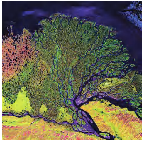
False-color image of Lena delta in Russia acquired by Landsat 7’s Enhanced Thematic Mapper plus sensor on February 27, 2000 (USGS EROS Data Center Satellite Systems Branch)
Delta Front Dynamics and Sensitivity. The delta front environment, positioned at the seaward edge of the delta, represents an extremely sensitive zone strongly influenced by waves, tides, sea-level fluctuations, and variations in sediment delivery. Many delta fronts feature offshore sandbars known as distributary mouth bars or barrier island systems oriented parallel to the coast. The Mississippi River delta exemplifies current challenges, experiencing substantial delta front loss due to subsidence resulting from reduced sediment supply, tectonic subsidence, sea-level rise, human activities including oil extraction and levee construction, and severe erosion from storms such as Hurricanes Hugo, Katrina, and Ike.
Classification Systems and Delta Types. Geologists have developed various classification schemes for deltas based on morphology and dominant processes. High-constructive deltas form where fluvial transport dominates the energy balance, resulting in either elongate forms, exemplified by the modern Mississippi delta with its distinctive bird's foot shape, or lobate forms, characteristic of older Holocene Mississippi lobes that have largely subsided below sea level.
High-destructive deltas develop in settings with high tidal and wave energy, where substantial fluvial sediment undergoes reworking before final deposition. Wave-dominated, high-destructive deltas typically accumulate sediment as arcuate barriers near river mouths, with the Nile and Rhone deltas serving as classic examples. In tide-dominated, high-destructive deltas, tidal action reworks sediment into linear bars radiating from river mouths, with sands on outer delta portions sheltering lower-energy mud and silt deposition areas inland. The Ganges delta and the Kikari and Fly River deltas in the Gulf of Papua New Guinea exemplify this type. In certain locations where tidal and wave currents prove exceptionally strong, these marine processes completely overwhelm fluvial deposition, effectively removing deltaic features. The Orinoco River in South America demonstrates this phenomenon, with its sediment transported southward along the coast without forming a true delta at the river mouth.
Specialized Delta Types and Economic Significance. Fan-deltas form when coarse sediment loads from alluvial fans deposit directly into standing water. Braid-deltas develop where braided streams encounter local base levels and deposit their coarse-grained loads. These specialized delta types represent important variations in deltaic sedimentation patterns.
Deltas create unique, diverse ecosystems where freshwater and saltwater environments intersect, encompassing highly varied settings including swamps, beaches, and shallow marine habitats. These areas rank among the world's most productive ecological zones. However, deltas also host some of the largest hydrocarbon fields globally, as fine-grained muds and carbonates serve as excellent source rocks, while sands form effective reservoir rocks and trap rocks. This dual significance creates ongoing tension between preserving natural ecosystems and utilizing planetary resources. Positioned at sea level, deltas remain exceptionally vulnerable to hurricanes and coastal storms, adding urgency to management and conservation efforts.
FURTHER READING: Burkett, Virginia R., D. B. Zikoski, and D. A. Hart. "Sea-Level Rise and Subsidence: Implications for Flooding in New Orleans, Louisiana." In U.S. Geological Survey Subsidence Interest Group Conference, Proceedings for the Technical Meeting. Reston, Va.: U.S. Geological Survey. USGS Water Resources Division, Open File Report Series 03-308, 2003: 63-70.
Davis, R., and D. Fitzgerald. Beaches and Coasts. Malden, Mass.: Blackwell, 2004.
Leatherman, Stephen P., ed. Barrier Islands, from the Gulf of St. Lawrence to the Gulf of Mexico. New York: Academic Press, 1979.
National Research Council. Drawing Louisiana's New Map: Addressing Land Loss in Coastal Louisiana. Washington, D.C.: National Academies Press, 2005.
Date added: 2026-04-26; views: 168;