Desert Formation, Classification, and Environmental Dynamics: A Comprehensive Overview
Deserts, defined as the driest environments on Earth, receive less than 250 mm (one inch) of precipitation annually. In these arid regions, the potential evapotranspiration consistently exceeds the actual rainfall, creating a persistent moisture deficit. Currently, approximately 30 percent of the global land surface is classified as desert, with the United States containing about 10 percent arid territory. Under the influence of shifting climate zones and evolving global climate patterns, a significantly larger portion of the planet faces the risk of desertification.
The majority of deserts are characterized by high temperatures, with the highest recorded temperature of 136°F (58°C) documented in the Libyan Desert. Elevated temperatures drive extreme evaporation rates, often exceeding precipitation by substantial margins; many arid regions evaporate twenty times the amount of rainfall received. In areas such as the northern Sahara, evaporation rates can reach 200 to 300 times the minimal precipitation from rare storm events. Deserts are also notable for dramatic diurnal temperature variations, frequently fluctuating by 50–70°F (28–39°C) between day and night. These extreme thermal shifts contribute to physical weathering processes capable of fracturing boulders. Wind is another dominant feature, generating frequent sand and dust storms driven by convective air movement, where heated daytime air rises and creates pressure gradients that draw in surrounding air. Airflow patterns shift considerably between day and night due to substantial temperature contrasts and are further influenced by adjacent water bodies that maintain relatively stable thermal conditions over 24-hour cycles.
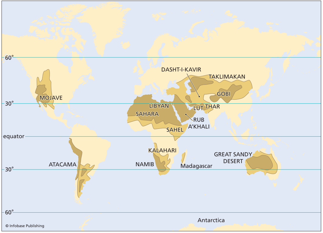
World map showing location of deserts: Note how most deserts are concentrated between 15° and 30° latitude
Diverse desert types occur across various global locations, each forming through distinct climatic and geographic mechanisms. Some deserts arise from large-scale global atmospheric circulation patterns, while others develop in continental interiors situated far from oceanic moisture sources. Additional formations include rain-shadow deserts located on the leeward sides of mountain ranges, where descending air is characteristically dry, as well as coastal deserts influenced by cold, upwelling ocean currents that reduce air temperature and atmospheric moisture-holding capacity. Polar deserts represent another category, where extremely cold, dry air results in sublimation and evaporation rates that far exceed annual snowfall, with certain regions in Antarctica remaining devoid of significant ice cover for millennia.
Deserts exhibit a distinctive assemblage of landforms and associated hazards. The sand dune, a mobile accumulation of sediment shaped by wind transport, stands as the most iconic desert landform. Due to persistently windy conditions, hazards frequently involve windborne sand and dust, which can be transported globally, influencing sedimentation patterns and climate dynamics. Intense sandstorms possess sufficient force to remove automotive paint or abrade exposed skin. Additional hazards in these environments include flash floods, debris flows, rock avalanches, extreme heat, and severe temperature fluctuations.
Droughts are conceptually distinct from deserts; a drought represents an extended precipitation deficit in a region that typically receives substantial rainfall. A desert experiencing its characteristic low precipitation does not constitute a drought condition, whereas a more humid region facing a significant rainfall shortfall would be considered in drought. Prolonged drought conditions can ultimately transform affected areas into desert landscapes. The consequences of drought often include widespread famine, vegetation loss, mortality, and the displacement or mass migration of human populations.
Desertification refers to the process by which productive lands are converted to desert, typically driven by prolonged drought coupled with anthropogenic stressors. Contributing factors include unsustainable agricultural practices, overexploitation of surface and groundwater resources, and population pressures exceeding environmental carrying capacity. Natural climatic variability can shift aridity belts over time, as evidenced by the Sahel region of northern Africa, which has experienced severe droughts in recent decades. Overpopulated and environmentally stressed regions, such as parts of the Middle East and the desert southwest of the United States, face elevated risk of permanent desertification should major droughts occur.
Location and Formation of Deserts. Over 30 percent of Earth’s land area is classified as arid or semiarid, with desert distributions forming patterns that reveal underlying developmental processes. Six primary desert categories are recognized based on geographic position relative to continental margins, oceans, and mountain systems: trade wind (Hadley cell) deserts, continental interior or midlatitude deserts, rain-shadow deserts, coastal deserts, monsoon deserts, and polar deserts.
Trade Wind, or Hadley Cell, Deserts. Many of the world’s largest and most renowned deserts occupy two latitudinal belts between 15° and 30° north and south. This group includes the Sahara, the world’s largest desert, along with the Libyan Desert of North Africa. Other examples are the Syrian Desert, Rub‘ al-Khali (Empty Quarter), and Great Sandy Desert of Arabia; the Dasht-e-Kavir, Lut, and Sind of southwest Asia; the Thar Desert of Pakistan; and the Mojave and Sonoran Deserts of the United States. In the Southern Hemisphere, this category encompasses the Kalahari Desert of Africa and the Great Sandy Desert of Australia. The formation of the Atacama Desert in South America, recognized as the world’s driest non-polar region, is partially attributed to its position within these latitudes.
The location of these deserts is governed by large-scale atmospheric circulation driven by solar energy. Intense solar heating at the equator induces atmospheric upwelling, where rising air cools and releases moisture through equatorial thunderstorms. This now-drier air diverges poleward at high altitudes, undergoing further cooling and desiccation before descending in two circumglobal belts between 15–30° north and south latitude. These descending, cold, dry air masses, known as Hadley cells, create conditions highly conducive to desert formation. As this air returns toward the equator, it generates dry, warming winds that dissipate cloud cover and increase surface solar radiation, amplifying aridity.
Deserts originating from global circulation patterns exhibit particular sensitivity to climate variability; minor shifts in circulation can trigger significant expansion or contraction of these arid regions. The sub-Saharan Sahel has experienced multiple episodes of such fluctuation, resulting in substantial population displacement and mortality. During expansion phases, croplands desiccate, and water resources become insufficient to sustain human and livestock populations, establishing desert expansion as a fundamental driver of severe famines.
Continental Interior and Midlatitude Deserts. Certain terrestrial regions lie at such great distances from oceanic moisture sources that atmospheric weather systems arrive with most precipitable water already depleted. This aridity intensifies when weather systems must traverse mountain ranges or plateaus, as orographic lifting induces moisture loss. The Taklimakan-Gobi region of China, situated on the Alashan Plateau south of the Mongolian steppe, and the Karakum Desert of western Asia exemplify this category. The Gobi represents the world’s northernmost desert, characterized by sand dunes reaching 1,000 feet (305 m) in height, composed of coarser-than-typical sand and gravel deposited by wind. This historically significant region witnessed conquests by Genghis Khan, Ming dynasty warriors, and the People’s Army of China, with battle remnants such as the abandoned city of Khara Khoto remaining preserved in the sands.
Rain-Shadow Deserts. A third desert type develops on the leeward sides of major mountain ranges, exemplified by the sub-Andean Patagonian Gran Chaco and Pampas regions of Argentina, Paraguay, and Bolivia, with similar effects contributing to the Mojave and Sonoran Deserts. As moisture-laden air masses encounter mountain barriers, they are forced to ascend, undergoing cooling that reduces their capacity to retain moisture. Consequently, precipitation releases on the windward slopes, creating exceptionally wet conditions in areas such as the western Cascades, western Sierra Nevada, and western Andes. Conversely, the descending air on the leeward slopes warms adiabatically, increasing its moisture-holding capacity while remaining dry, resulting in arid conditions. This orographic mechanism explains the pronounced dryness of the eastern sub-Andean region and the southwestern United States deserts.
Rain-shadow deserts typically exhibit mountainous topography due to their formation processes and are associated with mass wasting hazards, including landslides, debris flows, and avalanches. Occasional storm systems that surmount the rain-shadow barrier can deliver precipitation to highland areas, generating flash floods that emerge from mountain canyons onto adjacent plains and intermountain basins.
Coastal Deserts. Certain deserts occupy coastal locations where oceanic proximity might intuitively suggest greater moisture availability. The Atacama Desert, situated along the Peru-Chile coast, stands as the driest non-polar location on Earth. The Namib Desert of southern Africa, historically known as the Skeleton Coast, represents another coastal desert where extreme aridity results in mortality for fauna venturing from more humid interior regions, with skeletal remains preserved in the shifting sands.
These coastal deserts form despite oceanic adjacency due to cold ocean currents that upwell from deep marine environments, cooling the overlying atmosphere. This cooling reduces the air’s capacity to hold moisture, producing conditions analogous to rain-shadow deserts and effectively suppressing precipitation.
Monsoon Deserts. In certain regions, seasonal wind system variations produce alternating wet and dry periods. The Indian Ocean monsoonal system delivers substantial summer rainfall via southeast trade winds transporting onshore moisture. However, as these cloud systems traverse India, they deplete moisture reserves and must ascend the Aravalli Mountain range. The Thar Desert of Pakistan and the Rajasthan Desert of India occupy the leeward side of this barrier, receiving minimal seasonal moisture.
Polar Deserts. The final desert classification comprises polar deserts, primarily found in the Dry Valleys of Antarctica, portions of Greenland, and northern Canada, encompassing approximately 3 million square miles (7.8 million km²). These environments feature cold, descending air masses with minimal moisture content, where evaporation and sublimation potential greatly exceeds precipitation. Maximum temperatures during the warmest months do not exceed 50°F (10°C), with annual precipitation below one inch (2.5 cm). Some areas within Antarctica’s Dry Valleys have remained ice-free for thousands of years.
Polar deserts lack extensive sand dune fields, instead featuring gravel plains and barren bedrock. Landform development is dominated by frost wedging, a process where freeze-thaw cycles allow water infiltration into rock fractures; subsequent freezing expands the water, fracturing and displacing rock fragments. This process generates extensive talus slopes adjacent to mountain fronts, which remain susceptible to frequent rock falls.
Loess. Loess, consisting of wind-deposited silt and clay, forms uniform blankets across varied elevations, distinguishing it from fluvial deposits. Strong winds traversing desert regions entrain fine silt and clay particles, transporting them thousands of miles from their source. Evidence of this long-distance transport includes Chinese dust deposited in Hawaii and Saharan dust reaching Europe. This aeolian dust influences global climate patterns and, during extreme events such as the 1930s Dust Bowl, has achieved sufficient density to substantially reduce solar radiation.
Contemporary research indicates that windblown dust plays a significant role in global climate regulation. Saharan dust storms can circumnavigate the globe, partially attenuating incoming solar radiation. Dust particles may also serve as condensation nuclei for raindrop formation, functioning as a natural cloud-seeding mechanism. As global warming increases storm intensity and frequency while promoting desert expansion, dust storms may introduce a self-regulating feedback loop, potentially moderating global temperatures and enhancing precipitation.
Desert Landforms. Desert landscapes exhibit remarkable beauty through sculpted mountains, steep-walled canyons, and extensive gravel plains, yet they also rank among Earth’s most hazardous terrains. The regolith, or weathered rock and soil mantle, in deserts remains thin, discontinuous, and notably coarser-grained than in humid environments, resulting primarily from mechanical weathering processes. Chemical weathering is limited due to scarce moisture. The coarse particle size generated by mechanical weathering contributes to steep slopes eroded from cliffs and escarpments.
Much of the desert regolith features a dark coating of manganese and iron oxides known as desert varnish. This patina forms through combined microbial activity and chemical reactions involving fine manganese dust transported and deposited by wind.
Date added: 2026-04-26; views: 185;