
Thermohaline Circulation: The Ocean's Climate Engine and Its Impact on Global Change
Thermohaline circulation represents the global-scale, density-driven movement of ocean water, primarily controlled by variations in temperature (thermo-) and salinity (-haline). This vertical mixing is the principal mechanism for transferring heat from the equator toward the poles and for ventilating the deep ocean. The process begins with the formation of extremely dense, cold, and salty water in polar regions, notably in the North Atlantic near Greenland and in the Weddell Sea of Antarctica. This dense water sinks to abyssal depths, forming cold bottom water masses that flow across ocean basins, while warmer surface waters move poleward to replace them, completing the global ocean conveyor belt.
The formation of this deep water is a critical climate regulator. In the North Atlantic, the northward-flowing Gulf Stream carries warm, salty surface water that releases heat to the atmosphere, moderating Europe's climate. As this water cools near Greenland, its density increases, causing it to sink—a process known as downwelling. This sinking action effectively acts as a pump, driving the entire Atlantic limb of the thermohaline circulation. The volume and rate of this deep-water formation account for approximately 30 percent of the solar energy input into the Arctic, highlighting its direct impact on the planetary heat budget.
Changes in the vigor of thermohaline circulation are intimately linked to glacial-interglacial cycles. During glacial periods, paleo-oceanographic data (like the age of bottom water inferred from carbon isotopes) indicates this circulation was significantly weaker. A primary cause is thought to be the southward shift of the polar front and the injection of large volumes of freshwater from melting ice sheets. This freshwater pulse lowers surface water salinity, reducing its density and preventing downwelling. Events such as the Younger Dryas cold period (~12,900 years ago) are classic examples of how a meltwater-induced slowdown in thermohaline circulation can trigger abrupt Northern Hemisphere cooling.
On shorter, decadal timescales, Heinrich Events—identified by layers of ice-rafted debris in North Atlantic sediments—mark periods of catastrophic iceberg discharges from the Laurentide Ice Sheet. These events represent a similar mechanism: a massive influx of freshwater from melting icebergs caps the ocean surface, stifling deep-water formation and leading to rapid regional and global cooling. This demonstrates how ice-sheet dynamics can force climate variability through oceanic feedbacks on human-relevant timescales.
The climatic influence of thermohaline circulation extends globally. Its strength affects upwelling systems, which bring nutrient-rich deep water to the surface, fueling marine ecosystems. Furthermore, variations in circulation rigor correlate with precipitation patterns; for instance, weakened circulation is associated with droughts in the Sahel region of Africa due to reduced evaporation and moisture transport. The circulation also modulates atmospheric CO2 levels. Vigorous circulation brings deep, carbon-rich waters to the surface, potentially releasing CO2, while a sluggish system can enhance oceanic CO2 storage, contributing to global cooling.
The growth of the Antarctic ice sheet in the Middle Miocene (~14 million years ago) is linked to active thermohaline circulation that increased moisture delivery to the continent as snow. This ice-sheet growth amplified global temperature gradients, intensified atmospheric circulation, and contributed to mid-latitude aridification. Ultimately, the complex interplay between ocean circulation, ice sheets, and atmospheric CO2 underscores that thermohaline circulation is not merely a passive feature but a dynamic, central driver of Earth's climate system across millennia to decades. Ocean basin topography, including mid-ocean ridges and trenches, further steers and constrains these deep-water pathways, adding another layer of complexity to this planetary climate engine.
El Niño-Southern Oscillation (ENSO): Dynamics, Global Climate Impacts, and Environmental Effects
The El Niño-Southern Oscillation (ENSO) is a dominant quasi-periodic climate pattern arising from complex interactions between the tropical Pacific Ocean and the global atmosphere. It represents one of the most significant sources of interannual variability in global atmospheric and oceanic circulation, profoundly influencing weather and climate across the planet. Arid and semiarid regions, particularly those governed by Hadley Cell circulation, are especially susceptible to its shifts. Historical analysis suggests that ENSO-scale fluctuations can account for major climatic disasters, including the Dust Bowl of the 1930s in the United States and the catastrophic droughts and famines in the Sahel, Ethiopia, and Sudan during the 1970s and 1980s.
This coupled ocean-atmosphere phenomenon fundamentally alters drought frequency and can accelerate the desertification of ecologically stressed lands. The system's behavior is rooted in the migration of the Hadley Cells and the associated zone of most intense solar heating. Among several zonal feedback systems, the Austro-Asian system is the most influential. During normal Northern Hemisphere summers, the primary heating center shifts to the Indian subcontinent, initiating the Indian monsoon and drawing in air that ascends and flows outward toward Africa and the central Pacific. In winter, the intense heating migrates to the maritime continent of Indonesia and Australia, generating a strong low-pressure system.
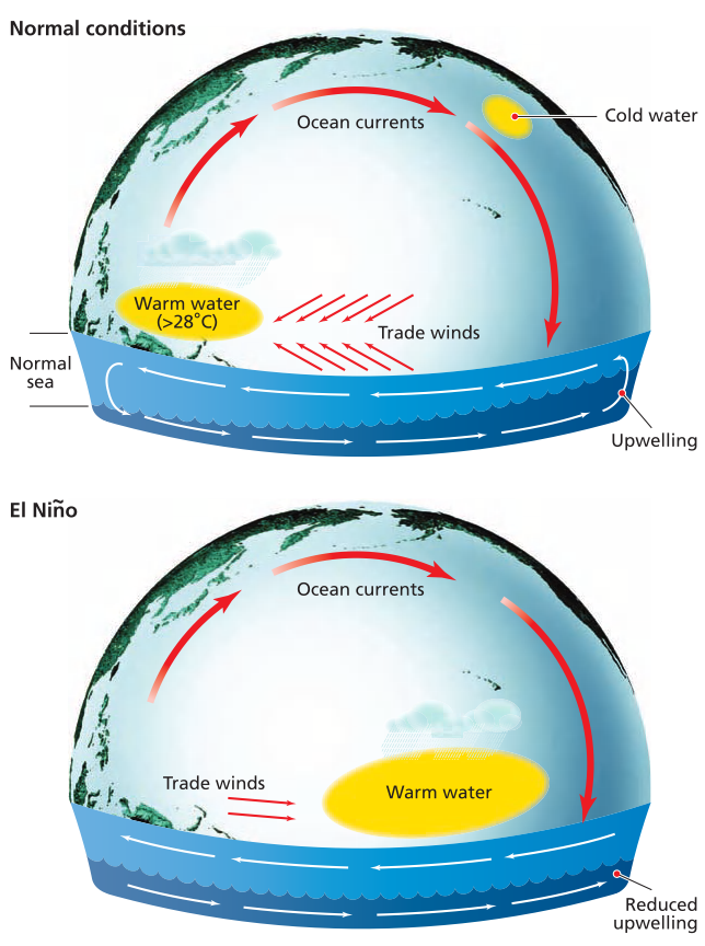
Schematic diagrams of the different patterns of ocean and air circulation over the Pacific associated with El Niño and normal conditions
Under this stable, normal phase, air rises over the warm western Pacific, flows eastward at high altitude, and sinks over the cold eastern Pacific near Peru. This downwelling is driven by the cooling effect of upwelling, cold, nutrient-rich ocean currents. The resulting pressure gradient fuels the easterly trade winds, which push warm surface water westward, causing it to "pile up" in the western Pacific near Australia. This configuration creates a self-reinforcing positive-feedback mechanism: stronger upwelling off Peru enhances atmospheric sinking, while warmer western Pacific waters intensify atmospheric rise.
Approximately every two to seven years, this stable circulation enters a chaotic, unstable state, initiating an El Niño event. The Indonesian-Australian heating center shifts eastward, and the westerly wind barrier weakens. This collapse allows the vast reservoir of warm western Pacific water to flow eastward as an internal Kelvin wave, typically reaching the coast of Peru by December. During strong ENSO events, sea surface temperatures in the eastern Pacific can rise 22-24°C (40-43°F) and remain elevated for months.
Concurrently, the atmospheric circulation reverses in a process termed the Southern Oscillation. Dry, downwelling air shifts over Australia and Indonesia, while moist, upwelling air dominates the eastern Pacific and western South America. This reversal triggers catastrophic ecological shifts in Peru: the thermocline deepens, suppressing the cold upwelling, which decimates the anchovy population and collapses the fishing and guano-based fertilizer industries. Warm, humid air brings torrential rains, floods, and landslides to normally arid coastal regions, while elevated sea levels of 10-60 cm accelerate coastal erosion.
The termination of an El Niño event often triggers a vigorous overshoot into the opposite extreme, known as La Niña ("the girl"). Cold upwelling returns with ferocity off Peru, sometimes flooding the central equatorial Pacific with water as cold as 20°C (68°F). This phase reinvigorates the normal circulation pattern but with exaggerated intensity. The alternation between El Niño (warm phase), La Niña (cool phase), and neutral conditions drives profound global climate reorganization, accounting for roughly one-third of all variability in global rainfall patterns on yearly to decadal timescales.
The global climatic impacts of ENSO are vast and geographically diverse. It can induce flooding in the western Andes and southern California while causing severe drought in Venezuela, northeastern Brazil, and southern Peru. Its teleconnections often result in droughts across Africa, Indonesia, India, and Australia. Historical evidence links ENSO to the failure of the Indian monsoon in 1899, which caused a famine killing millions. Furthermore, the seven-year flood cycle of the Nile and prolonged desertification in the Sahel have been robustly correlated with ENSO phase changes, underscoring its role as a primary driver of global climate variability and humanitarian crises.
Date added: 2026-07-14; views: 114;