Turf City. Reykjavik, Iceland, 2008
Designed in 2008 by Nekton Studio, the Turf City masterplan was a finalist entry in the Vatnsmyri 102 Reykjavik masterplan competition. The competition rules stipulated the redevelopment of the existing domestic airport that borders the city of Reykjavik to its south.
The Turf City project constitutes a synthesis between a further development of the mat-building typology and a multiple ground and continuous surface approaches. In so doing, the project explored the spatial and organizational relationships produced between building mass and envelopes, the existing and projected landscape and ground conditions, and how these conditions may be fused into a coherent scheme that displays a strong relation to the local setting and spatial and formal ambience that conveyed Icelandic traits and sensibilities.
A driving conceptual theme was that of the traditional Icelandic turf house which combines building envelope and landscape as a thick constructed ground. Thus, the site was conceptually treated as a city-sized turf house. Although the proposal covered a range of criteria and strategic aims, the two elements that were key in its formation were the strategies for the production of an integrated urban fabric and landscape.
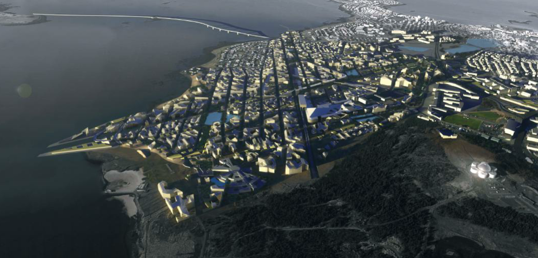
Rendered view of Turf City showing the massing organized in a mat-building-type manner and its relation to the surround context (i.e. the existing city fabric of Reykjavik in terms of building heights), and to the wider landscape in terms of surface continuity. Copyright: Nekton Studio
The Turf City scheme constitutes a series of multiple ground conditions, each with its own continuous surfaces as a new urban terrain and roofscape: sport and leisure scapes as landscaped surfaces for human use, landscape surfaces reserved for other species, etc. This new terrain is articulated according to the programme and occupation of the plan and registers sectionally as a change in height and in the degree of articulation of the terrain.
This fabric of 150 hectares was then organized by grid equivalent with that of Reykjavik city, which divides the massive ground into manageable territories for finer articulation, as well as proportionally relating the new fabric to the existing urban grain. The plan was developed through the strategic use of positioning and expanding the current landscape conditions that were present and used as the key infrastructural elements that connect existing conditions into the new scheme.
This included the existing parks and nature reserves; the site bordered one of the few areas in Reykjavik with dense tree foliage, as well as the coastline that borders the site to the south. To the north of the site the existing open park extends southward into the new fabric acting as a passive infrastructure that includes cycle paths and walkways. In addition to this, a new network of canals also extends southward, creating an intricate water system and new ponds that act as new habitats and focal points for new residential districts and which support present ecologies.
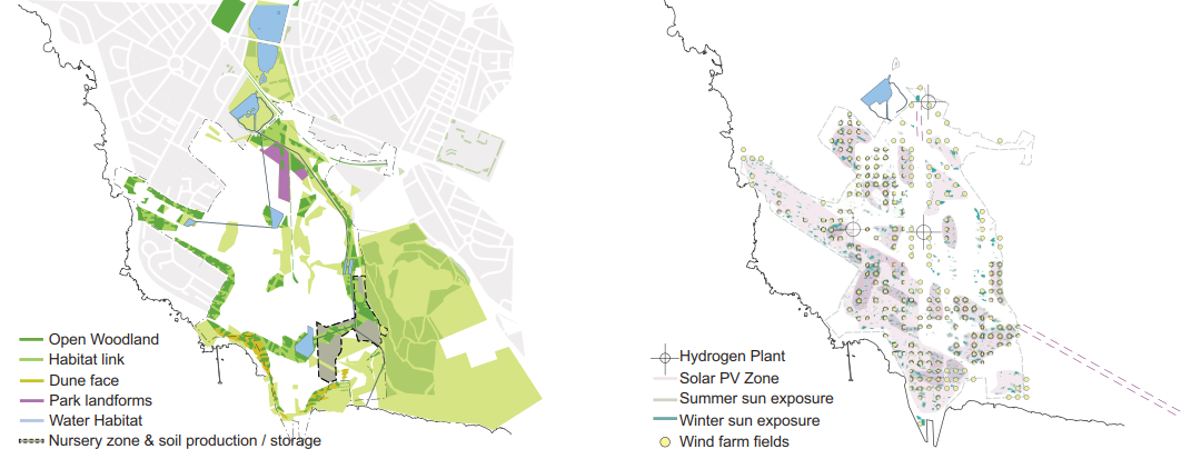
Diagrams of the Turf City masterplan, showing the ecological and energy strategy for the scheme. The ecological strategy offers varied landscapes and habitats for local species and wildlife to evolve and incorporates a strategy for replenishing the parklands and ground soil with zones dedicated to its production and storage via nurseries. The energy strategies include both mechanical and passive options, from solar PV zones to capture energy, to offering zones for sun exposure during the summer and winter months. Copyright: Nekton Studio
This expansion from the north also includes the Nordic House designed by Alvar Aalto whose original scheme included a nature reserve water feature that was integrated into the Turf City scheme. From the east of the site where the current woodland area is located there was proposed an expansion westward which would see the implementation of a tree nursery as a vital part of an expanded woodland condition across the site. To the south of the site the shoreline was intended to be reinforced with the new woodland, as well as the implementation of new dune land forms to support a range of microclimates and ecological niches.
The landscape and urban fabric strategies are merged in the formation of the building mass. Acting as building, landscape and infrastructure, this element is stitched into the network of foot and cycle paths, as well as canals and lakes and woodland. These elements were intended to culminate in a city fabric with human comfort and multi-species provisions as a priority. Comfort in the urban fabric of Reykjavik is determined mainly by high winds rather than by low temperatures. The roof stratum encourages the wind to skim over the planned development and the building articulation is planned to shelter key public areas from strong winds.
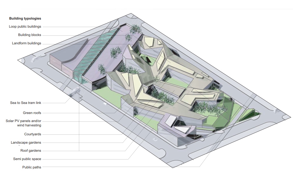
Detail of axonometric, showing a city block of the Turf City masterplan scheme, which includes the loop public building, the mat-building blocks and the land-form buildings. Also shown is the integration of the varied landscapes and infrastructures. Copyright: Nekton Studio
The expansion of the landscape features such as the woodland and the strategic placement of the building mass as hard landscape also act as windbreaks for open spaces. Located at the centre of the masterplan are the looped public buildings that take their planar formation from the runway corridors from the old airport. These buildings act as the primary hub for public transport and establish a core that connects to the various areas of the masterplan. The loop houses a new bus terminal for Reykjavik as well as a proposed high-speed rail link to Keflavik international airport.
The formation of the scheme on the scale of the city block was akin to the mat-building typology. This low and horizontal building type became the underpinning architectural departure point for the proposed ground-related urbanism. Most of the urban fabric was proposed within a single- to double-storey height range and, with the prevailing environmental constraints of high winds and limited sunlight in winter months, the use of a conventional figure–ground approach to the block parcelled plan was avoided. The production of a mat urbanism that focused mainly on the articulation of its section was paramount. This led to the plans being articulated with courtyard insertions that were deployed on varied levels and with varied uses, with some being connected to the adjacent interiors and others being part of a larger parkland strategy.
Date added: 2025-08-01; views: 440;