Evidence that led directly to plate tectonic theory
The situation changed after the Second World War as a result of the major increase in our understanding of the bathymetry of the deep ocean and the rocks that underlie these basins. For the first time scientists were able to construct detailed bathymetric maps of the sea floor beneath the oceans. It was found that there was a large and continuous mountain range running through the centre of many of the world’s oceans.
Detailed bathymetric surveys found that there was a valley in the centre of these mid-ocean mountain ranges that had the same shape as valleys caused by rifting on land. This was interpreted as evidence for the pulling apart of the ocean basins at their centre and thus provided some of the first direct evidence in support of continental drift (Figure 2.5).
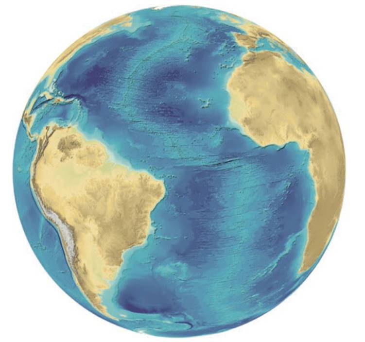
Figure 2.5. Bathymetric map of the Atlantic Ocean showing how Africa and Europe have drifted apart from the Americas. Transform faults can be seen crossing the mid-ocean ridge. (Source: courtesy of Martin Jakobsen who created the image using data from GEBCO; www.ngdc.noaa.ngg/gebco/gebco.html)
It was also found that the deepest parts of the world’s oceans were not, as had been expected, in the middle of the ocean but instead were located very close to the edge of the ocean, particularly within the Pacific. Prevailing theories had not predicted these major features and were unable to explain them.
Then in the 1960s, Harry Hess proposed that, deep within the Earth’s mantle, there are currents of low- density molten material that are heated by the Earth’s natural radioactivity (Hess, 1962). These form convection cells within the mantle. When the upward-moving arms of these convection currents reach the rigid lithosphere, they move along it, cooling as they go until eventually they sink back into the Earth’s interior. In the regions where the upward-moving limb of mantle material breaks through the crust of the sea floor, underwater volcanoes would appear, developing a mountain range supported by the hotter mantle material below.
Lava from these volcanoes erupted and then hardened to form new crust along the underwater mountain chain. As the limbs of the convection cell moved apart, they dragged the overlying ocean crust with them. Since the size of the Earth has remained constant, it is necessary to remove old crust at the same rate as it is being produced at the mid-ocean ridges. The great deep trenches around the Pacific were proposed as areas where the old crust dips down and disappears back into the Earth’s mantle.
The second piece of evidence to explain these sub- oceanic features came from the study of palaeomagnetism. Most igneous rocks contain some particles of magnetite (an iron oxide, Fe3O4), which is strongly magnetic. Volcanic lavas such as the basalt which erupts at the mid-ocean ridges are high in magnetite and erupt at temperatures in excess of 1000°C.
As the lava cools below 600°C, the Curie point, the particles of magnetite become oriented in the direction of the Earth’s magnetic field, recording that field permanently relative to the rocks’ location at the time they were erupted. If the Earth’s magnetic field changes subsequent to the formation of the igneous rock, the alignment of these particles will not be affected. When geologists began to study this palaeomagnetism, they discovered to their surprise that the direction of the Earth’s magnetic field reversed itself periodically.
A compass needle that points towards the North Pole today would point south during a period of reversal. It is still not known why these reversals take place but they have occurred once or twice every million years for at least the past 75 million years. In fact, there is evidence of magnetic reversals into the Pre- Cambrian (i.e. more than 600 million years ago). A magnetic reversal is not sudden but is very quick in geological time, taking about 20 000 years for completion.
In 1960, magnetometers were towed over the sea floor off the western coast of North America, by scientists from Scripps Oceanographic Institute. A clear pattern of stripes appeared, caused by changes in the polarity of the Earth’s magnetic field locked into the crust of the sea floor (Figure 2.6).
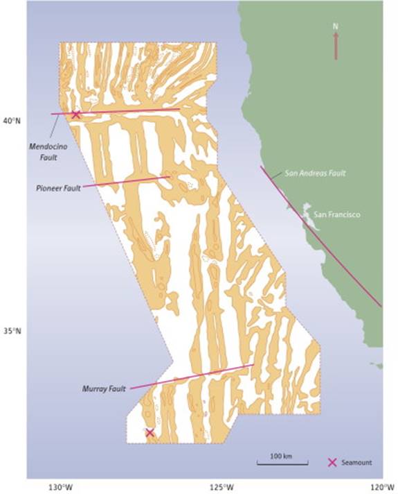
Figure 2.6. Magnetic anomalies of total magnetic field for the area off the western coast of California. Positive anomalies are shown in orange and negative anomalies in white. This was the first such map produced. (Source: after Mason and Raff, 1961)
However, at that time, the bathymetric maps of that region of the Pacific Ocean were considered classified information by the US Government, and the scientists involved were not able to relate the magnetic patterns to the mid-ocean ridge, which was subsequently found to run through the area. It was not until Vine and Matthews (1963) proposed that these stripes represented a recording of polar magnetic reversals frozen into the sea floor that we had the evidence needed to demonstrate ocean floor spreading.
As the molten basalt flowed out at the mid-ocean ridge, it solidified and retained the magnetic field existing at the time of formation. Sea floor spreading then moved this material away from the ridge on both sides to be replaced by more molten material. Each time the Earth’s magnetic field reversed it was preserved in the new basaltic lava crust. Vine and Matthews (1963) suggested that in such a case, there would be a symmetrical pattern of magnetic polarity stripes centred on the ridges and which would become progressively older as you travelled away from the ridge.
The third piece of evidence that appeared to create the new theory of plate tectonics came from the study of earthquakes. The global seismic network set up to monitor underground nuclear testing gave geophysicists much detailed information on the epicentres of earthquakes and the direction of their movement.
When maps were constructed of the worldwide distribution of earthquakes, it was found that there were narrow bands which were subject to frequent (and often destructive) earthquakes and relatively large areas of stable lithospheric crust in between. Isacks et al. (1968) looked not only at the precise epicentre of earthquakes (position and depth), but also at the direction of movement of the two layers of rock that caused these earthquakes.
As a result of this work, it became obvious that there were a series of relatively rigid plates which were moving about on the Earth’s surface colliding with one another. The continents, far from being crucial to this, appeared to be merely passengers being carried about on these moving plates. McKenzie and Parker (1967) put all this information together on a stringent geometrical basis and thus the theory of plate tectonics was born.
The final piece of evidence that confirmed plate tectonics, came from the ocean drilling programme (ODP). Cores were drilled in a variety of locations in the ocean basins. It was found that the thickness of sediment increased from the mid-ocean ridges towards the edge of the basin. The thickest (and oldest) sedimentary cover was found nearest to the continents. However, at no place in the ocean were sediments found that were over 200 million years old.
Date added: 2025-10-14; views: 365;