Understanding Earthquakes: Causes, Measurement, and Global Impact
Earthquakes represent one of Earth's most formidable natural phenomena, occurring when a sudden release of accumulated energy causes the ground to shake and vibrate through the passage of seismic waves from the source. These geological events can be extraordinarily devastating, historically killing tens to hundreds of thousands of people while leveling entire urban centers within seconds. A single significant earthquake may release energy equivalent to hundreds or thousands of nuclear detonations, resulting in billions of dollars in structural damage alongside profound human suffering. Beyond primary ground shaking, earthquakes generate secondary hazards including tsunamis, landslides, fires, famine, and disease outbreaks that extend their destructive impact on human populations and ecosystems.
Locations of significant earthquakes and plate boundaries. Shallow-focus earthquakes (in pink) are found at all types of plate boundaries; medium- and deep-focus quakes are found along subduction zones.
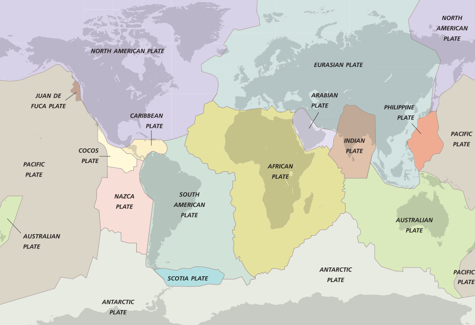
Tectonic Plate Boundaries and Earthquake Distribution. The majority of earthquakes occur along plate boundaries, where the lithosphere—Earth's outer rigid shell—is divided into approximately 12 major tectonic plates that move relative to one another alongside numerous smaller plates. Seismic activity predominantly concentrates where two plates interact, whether moving past each other along transform boundaries like southern California's San Andreas Fault or converging in subduction zones as observed in Alaska, Japan, Sumatra, and Mexico. A comprehensive global map of plate boundaries reveals that significant earthquakes over the past five decades cluster along these tectonic margins, with the largest events occurring where plates either collide or slide horizontally past one another. Minor seismic activity characterizes divergent boundaries, such as mid-oceanic ridges where magma upwelling creates new oceanic crust through seafloor spreading.
The San Andreas Fault System and Elastic Rebound Theory. Southern California experiences the highest earthquake frequency within the continental United States due to the Pacific Plate sliding northward relative to the North American Plate along the San Andreas Fault system. This boundary exhibits a distinctive stick-slip behavior, wherein the plates remain locked together while accumulating stress over decades or centuries as they slowly attempt to move past one another. When accumulated stresses eventually exceed the strength of the rocks, sudden rupture occurs, causing the plates to slip dramatically—up to 20 to 30 feet (5 to 7 meters)—within seconds, releasing energy as an earthquake. The elastic-rebound theory explains this process, describing how recoverable (elastic) stresses build within materials until reaching a critical breaking point, whereupon sudden failure releases stored energy. This phenomenon manifests visibly across active fault zones, where originally straight features such as fruit tree rows, fences, roads, and railroad lines become progressively bent before earthquakes, then straighten while becoming permanently offset following rupture events.
Intraplate Earthquakes and Historical Devastation. Certain regions distant from active plate boundaries remain susceptible to infrequent yet highly destructive earthquakes, demonstrating that seismic hazards extend beyond tectonic margins. Cities including Boston (Massachusetts), Charleston (South Carolina), and New Madrid (Missouri) have experienced historically significant intraplate earthquakes with widespread impacts. Between 1811 and 1812, three major earthquakes measuring magnitudes 7.3, 7.5, and 7.8 struck the New Madrid region, shaking nearly the entire United States and causing destruction reported as far away as Boston and Canada, where chimneys collapsed, plaster cracked, and church bells rang from ground motion. Historical earthquakes have produced catastrophic human tolls, including the 1556 Shaanxi earthquake in China, which killed between 800,000 and 900,000 people; the 1976 Tangshan earthquake, with estimated fatalities ranging from 242,000 to 800,000; and the 2004 Indian Ocean tsunami, which claimed approximately 286,000 lives. The 2008 magnitude 8.0 Wenchuan earthquake in China recorded an official death toll of approximately 90,000, though unofficial estimates suggest up to one million fatalities.
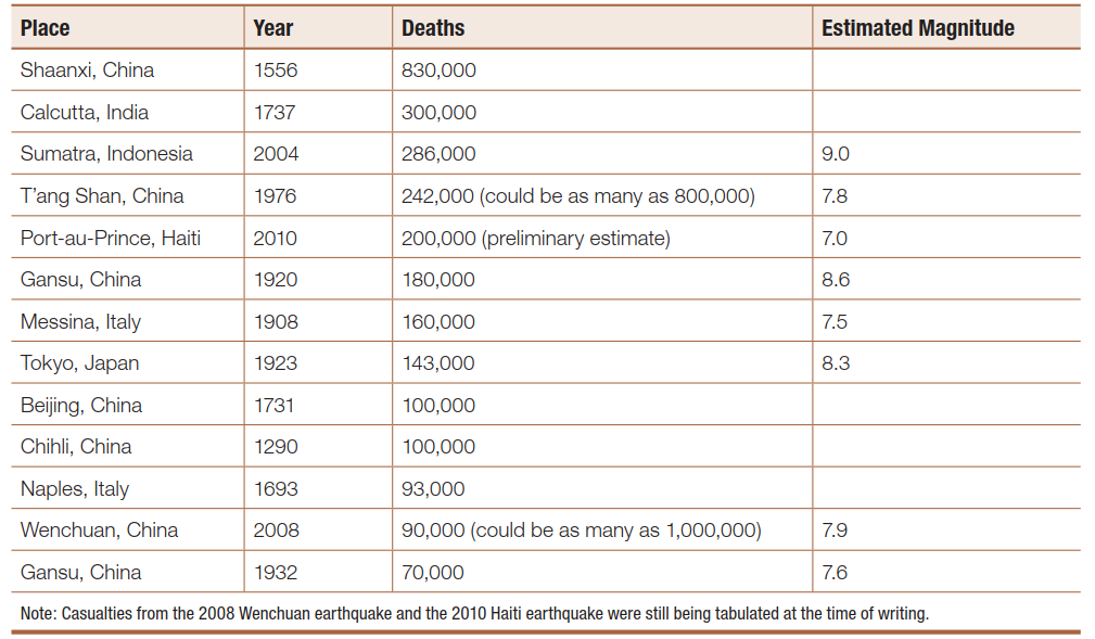
The 13 deadliest earthquakes in recorded history
Origins and Fault Mechanics. Earthquake origins encompass multiple mechanisms beyond fault motion, including volcanic eruptions, bomb blasts, landslides, and any sudden energy release within or upon the Earth's surface. Not all faults remain seismically active; the majority represent inactive structures from past geological periods, and among active faults, only certain segments exhibit significant earthquake potential. Some faults demonstrate aseismic creep, where adjacent blocks slide smoothly past one another without accumulating substantial strain or generating major earthquakes. In contrast, locked faults experience deformation and stress accumulation until reaching a threshold where sudden brittle failure releases accumulated energy during an earthquake event. Materials exhibit brittle behavior when responding to tectonic pressures through cracking or fracturing, with earthquakes representing this response in the upper crustal layers. At greater depths where temperature and pressure conditions increase, rocks deform ductilely, flowing like viscous material rather than rupturing abruptly.
Focus, Epicenter, and Seismic Wave Propagation. An earthquake originates at the focus (hypocenter)—the point within Earth where energy first releases and where rocks on one side of a fault move relative to the opposite side. Following the initial slip event, the surrounding region experiences numerous aftershocks as adjacent rocks adjust to the deformation caused by the primary earthquake. The epicenter designates the surface point lying vertically above the focus, representing the location where seismic effects typically concentrate. During major earthquakes, the Earth's surface deforms into waves that propagate across the landscape similarly to ocean waves, producing spectacular and often destructive ground motion. Seismic waves radiate outward in all directions analogous to sound waves or ripples spreading across water after a stone is thrown into a still pond, with the ground returning to its original shape after wave passage despite widespread damage to human structures.
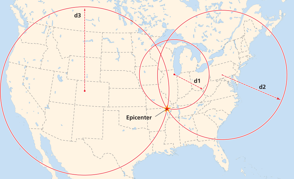
Method of locating epicenters by calculating the distance to the source from three different seismic stations. The distance to the epicenter is calculated using the time difference between the first arrivals of P- and S-waves. The unique place that the three distance circles intersect is the location of the epicenter
Types of Seismic Waves. Earthquakes generate distinct seismic wave types: body waves that travel through Earth's interior from the focus, and surface waves that propagate from the epicenter along the ground surface. Body waves travel faster than surface waves, while surface waves cause the majority of destruction by temporarily altering the ground's surface geometry during their passage. Primary waves (P-waves) represent compressional body waves that deform materials through volume and density changes, traveling through solids, liquids, and gases at velocities of approximately 3.5 to 4 miles per second (6 kilometers per second). These waves produce back-and-forth motion and typically arrive first at seismograph stations, hence their designation as primary waves. P-waves cause substantial damage by temporarily altering ground volume through expansion and contraction, rupturing buried infrastructure such as gas pipelines that cannot accommodate such shape changes, frequently igniting fires that historically have caused destruction comparable to ground shaking itself. The 1906 San Francisco earthquake dramatically illustrated this phenomenon, where fires consumed much of the city for days following the initial shaking, while the 1995 magnitude 7.3 Kobe earthquake in Japan similarly demonstrated fire-related devastation from ruptured gas lines and home heating systems.
Secondary waves (S-waves) constitute the second body wave type, representing shear waves that alter material shape without changing volume, propagating only through solids at velocities approximating 2 miles per second (3.5 kilometers per second). These waves displace material perpendicular to their travel direction, generating alternating sideways motions that can destabilize building foundations—analogous to rapidly pulling a tablecloth from beneath a fully set table, potentially leaving structures relatively intact while detached from their foundations. Surface waves propagate more slowly than body waves but often cause the most destruction through complex twisting and circular motions. The temporal separation between wave arrivals provides a critical safety window: recognizing that body waves have passed may allow brief evacuation before more destructive surface waves arrive.
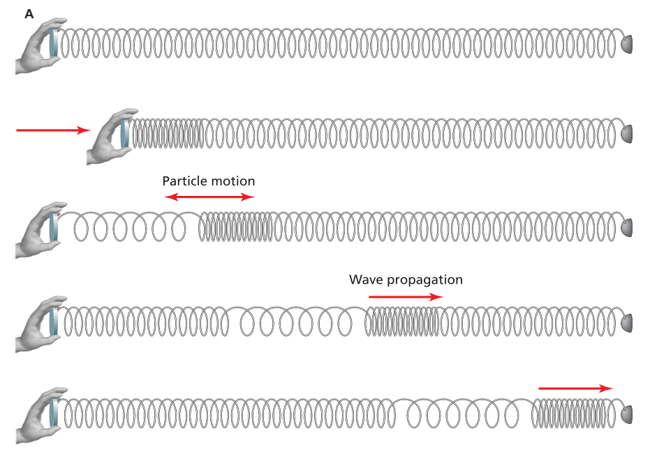
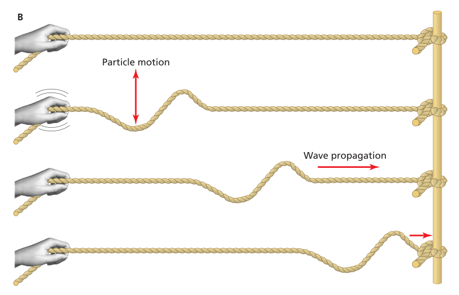
Analogy to seismic P- and S-waves using slinky and rope
Seismograph Technology and Earthquake Measurement. Seismographs constitute the primary instruments for measuring earthquake intensity, utilizing an ink-filled stylus to record ground movements on continuously rotating graph paper, with modern digital versions capturing data directly for computational analysis. When ground shaking occurs, the stylus produces characteristic zigzag traces that clearly display the sequential arrival of P-waves, S-waves, and surface waves. These instruments operate on inertial principles, employing a heavy mass suspended from a string or spring that remains stationary during ground motion due to inertia—the resistance of large masses to sudden movement. The recording paper attached to the moving ground traces the seismic motion while the stylus remains stationary, enabling precise measurement. Seismographs are deployed in series as pendulums and springs to record ground motion across multiple directions, with sensitivity capable of detecting motions as small as one hundred-millionth of an inch—equivalent to sensing ground vibration from a car several blocks away.
Seismograph records exhibit distinctive signatures allowing geologists to differentiate between earthquake types, including fault-generated earthquakes, volcanic earthquake swarms associated with magma movement, and explosions from construction activities or nuclear detonations. This interpretive capability has made seismology essential for nuclear test-ban treaty verification, employing seismologists worldwide to monitor seismic activity and verify compliance with international nuclear testing prohibitions.
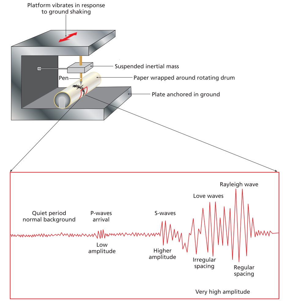
Schematic diagram of an inertial seismograph showing a large inertial mass suspended from a spring. The mass remains stationary as the ground and paper wrapped around a rotating drum move back and forth during an earthquake, creating the seismogram
Earthquake Magnitude Scales. Earthquake intensity spans an enormous range, from imperceptible microearthquakes occurring thousands of times daily to catastrophic events causing mass casualties and complete destruction. The Richter scale, developed by Charles F. Richter, provides the most common magnitude measurement based on seismic wave amplitudes measured at 61 miles (100 kilometers) from the epicenter. This logarithmic scale assigns each whole-number increment to a tenfold increase in wave amplitude, a necessary mathematical transformation given that earthquake energy varies by factors exceeding one hundred million. Energy release increases even more dramatically with magnitude increments because larger earthquakes generate proportionally more high-amplitude waves, and energy relates to the square of amplitude. Consequently, each unit increase on the Richter scale corresponds to approximately a 30-fold increase in released energy. The largest recorded earthquakes include the 1964 Alaska earthquake (magnitude 9.2), the 1960 Chile earthquake (magnitude 9.5), and the 2004 Sumatra earthquake (magnitude 9.0), each releasing energy exceeding 10,000 Hiroshima-sized nuclear bombs.
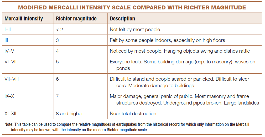
Prior to modern inertial seismograph development, earthquake intensity was measured using the modified Mercalli intensity scale, developed by Giuseppe Mercalli in the late 1800s. This scale quantifies shaking intensity based on human-perceived vibration for smaller events and structural damage patterns for larger earthquakes. The Mercalli scale's primary limitation involves its distance dependency—locations near the epicenter may record IX or X intensities while distant sites register only I or II for the same earthquake. Despite this limitation, the modified Mercalli scale remains valuable for estimating magnitudes of historical earthquakes predating modern instrumentation, enabling seismologists to assess seismic hazards using historical records.
Date added: 2026-04-26; views: 166;