Understanding Earthquake Hazards: A Comprehensive Guide to Seismic Risks and Ground Motion Effects
Earthquakes generate a diverse array of specific hazards that can be categorized as primary, secondary, and tertiary effects. Primary hazards include ground motion, ground breaks (also termed faulting), mass wasting, and liquefaction. Secondary and tertiary hazards represent indirect consequences triggered by the seismic event itself, such as tsunamis in open ocean and bay environments, along with seiche waves that oscillate within enclosed basins. Additional indirect effects encompass fires and explosions resulting from utility and pipeline disruptions, as well as changes in ground level that may alter habitats, modify groundwater tables, displace coastlines, cause employment losses, and force population displacement. Financial losses affecting individuals, insurance companies, and businesses frequently reach tens of billions of dollars even from moderate-magnitude seismic events.
Ground Motion as a Primary Seismic Hazard. Ground motion constitutes one of the most significant primary hazards associated with earthquakes, arising from the passage of seismic waves through populated regions. The most destructive seismic waves are surface waves, which during severe earthquakes can visibly deform the Earth's surface into propagating undulations. Ground motion is typically experienced as shaking, producing the familiar rattling and displacement of objects from shelves commonly reported during minor seismic events. The extent of destruction resulting from specific levels of ground motion depends substantially on the design standards and construction quality of buildings and infrastructure according to established seismic codes.
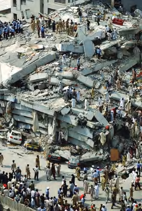
Collapsed 10-story apartment building in Islamabad, Pakistan, after earthquake October 8, 2005: The building pancaked as one floor fell, thereby causing each lower floor to collapse. (AP images)
The intensity of ground motion associated with an earthquake generally increases with the magnitude of the event, though it also depends significantly on the nature of the underlying substratum. Loose, unconsolidated soil and artificial fill tend to amplify shaking compared to solid bedrock foundations. The Loma Prieta, California, earthquake of 1989 dramatically demonstrated this phenomenon, as areas constructed on solid bedrock experienced minimal vibration and destruction, while regions built on loose clays sustained the most severe damage. Much of the San Francisco Bay Area is situated on loose clays and mud deposits, including the Nimitz Freeway, which collapsed during the event. The Marina district experienced the worst destruction from ground shaking despite being located far from the earthquake epicenter, as it was constructed on unconsolidated landfill that amplified the seismic waves, causing numerous building collapses and gas line ruptures that initiated fires.
Additional variation in ground motion severity occurs due to differences in how various bedrock types transmit seismic waves. Earthquakes occurring in the western United States typically affect smaller geographic areas compared to those in the central and eastern regions. This disparity exists because western bedrock, particularly in California, consists of relatively softer materials, whereas eastern regions feature harder igneous and metamorphic bedrock. Harder, denser rock transmits seismic waves more efficiently than softer, less dense materials, meaning earthquakes of equivalent magnitude may produce more severe shaking over larger areas in the eastern United States than in the western region.
Ground motion is quantified through acceleration measurements, representing the rate of change of velocity. This type of force resembles the sensation experienced when accelerating in a vehicle, where the driver feels gently pushed backward against the seat during speed increases. Gravity constitutes another common acceleration-based force, measuring 9.8 meters per second squared, or 1g. Humans experience difficulty maintaining standing posture, and buildings begin to fail when subjected to accelerations reaching one-tenth of gravity (0.1g). Large earthquakes can generate accelerations exceeding, and even doubling or tripling, the force of gravity, with the capacity to uproot large trees, propel objects through walls and structures, and cause nearly any construction to collapse.
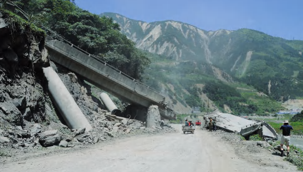
Damage from ground shaking and landslides in Yingxiu, Sichuan Province, China, from May 12, 2008, magnitude 7.9 earthquake
Damage commonly associated with ground motion and seismic wave propagation includes building swaying and pancaking phenomena. During earthquakes, structures may sway with characteristic frequencies determined by their height, dimensions, construction materials, underlying substrate, and the earthquake's intensity. This movement causes heavy objects to shift rapidly within buildings, generating substantial destruction. Shaking intensity typically increases with building height, often causing concrete floors at upper levels to separate from walls and corner fastenings, leading to progressive floor collapse or pancaking that crushes everything between successive levels.
Ground Breaks and Surface Ruptures. Ground breaks, also referred to as ruptures, develop where faults intersect the Earth's surface and may also be associated with mass wasting, involving the downslope movement of large land blocks. These ground breaks exhibit horizontal, vertical, or combined displacements across them and can cause considerable structural damage. Fissures opening during earthquakes predominantly relate to the mass movement of material down slopes rather than directly representing the fault trace breaking the surface. During the Alaskan earthquake of 1964, ground breaks displaced railroad lines by several yards, fractured through streets, houses, storefronts, and other structures, and caused portions of these features to drop significantly relative to adjacent sections. Most ground breaks during this event were associated with slumping, representing movement of upper soil layers downhill toward the sea, and contributed substantially to pipeline and communication cable ruptures.
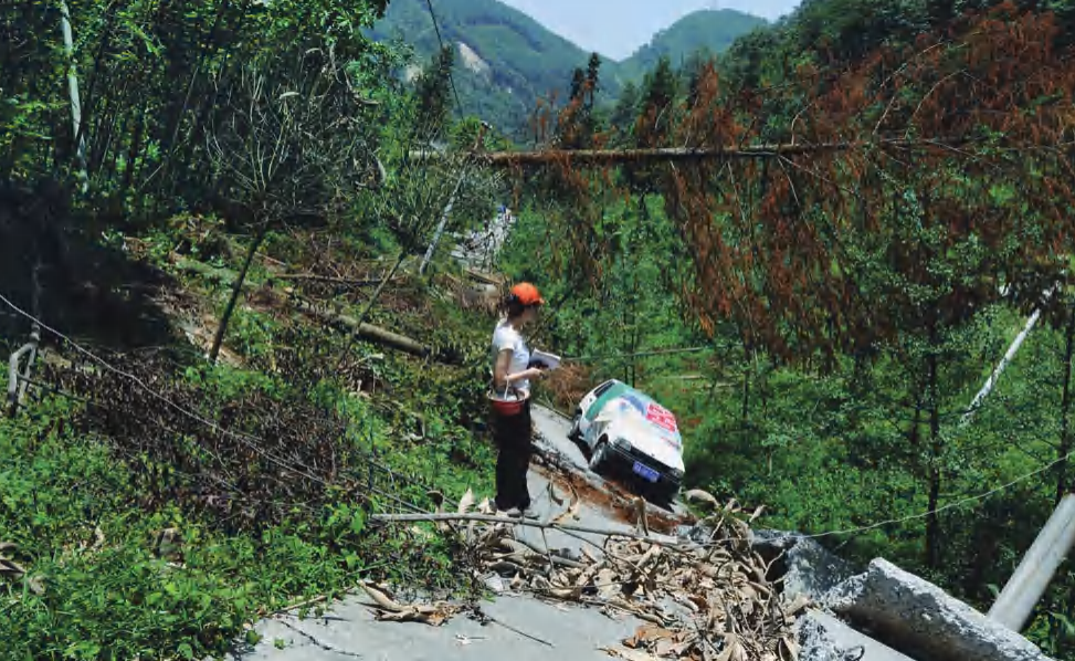
A second photograph of damage from ground shaking and landslides in Hongkon, Sichuan Province, China, from May 12, 2008, magnitude 7.9 earthquake
Mass Wasting Processes During Earthquakes. Mass wasting refers to the downslope movement of material, typically occurring as gradual creeping of soils and rocks under normal conditions. However, during earthquakes, extensive volumes of rock, soil, and constructed features within affected areas may suddenly collapse in landslides. Earthquake-induced landslides occur in regions characterized by steep slopes or cliffs, including areas of California, Alaska, South America, Turkey, and China. One of the most devastating recorded earthquake-induced landslides occurred during the magnitude 7.9 Wenchuan, China, earthquake of 2008, when several villages were completely buried under hundreds of feet of debris from adjacent mountain collapses, resulting in thousands of fatalities.
During the magnitude 9.2 Alaska earthquake of 1964, landslides destroyed power plants, homes, roads, and railroad infrastructure. Some landslides occurred undersea and along coastal areas, with large portions of Seward and Valdez situated atop submarine escarpments that slid out to sea during the earthquake in massive submarine landslides, becoming submerged. The Turnagain Heights residential area near Anchorage, constructed on cliffs offering views of the Alaska Range and Aleutian volcanoes, slid toward the sea along a series of curving faults intersecting a weak shale unit known as the Bootlegger Shale. During the earthquake, this shale unit lost all strength, becoming nearly cohesionless, while the shaking of overlying soil and rock caused the entire neighborhood to slide along the shale unit, resulting in complete destruction.
Liquefaction Mechanisms and Impacts. Liquefaction constitutes a process where sudden shaking of specific types of water-saturated sands and muds transforms previously solid sediments into slurry possessing liquid-like consistency. This phenomenon occurs when shaking causes individual sediment grains to separate, allowing water to migrate between grains, causing the entire water-sediment mixture to behave as a fluid. Earthquakes frequently induce liquefaction of sands and muds, with structures built on liquefied sediments suddenly sinking into them as though resting on thick fluid. Liquefaction caused the Bootlegger Shale during the 1964 Alaska earthquake to become so weak that it destroyed the Turnagain Heights neighborhood.
Liquefaction during earthquakes also causes sinking of sidewalks, telephone poles, building foundations, and other infrastructure. A notable example occurred during the Japan earthquake of 1964, where entire rows of apartment buildings rolled onto their sides while sustaining minimal internal damage. Liquefaction additionally causes sand to bubble to the surface during earthquakes, forming mounds up to several tens of feet high known as sand volcanoes or creating sand ridges.
Ground Level Changes and Geomorphic Alterations. During earthquakes, shifting earth blocks relative to one another may produce changes in ground level, base level, water table elevation, and high-tide marks. Particularly substantial shifts have been documented from historically significant earthquakes, including the magnitude 9.2 Alaskan earthquake of 1964 and the Sumatra earthquake of 2004. In 1964, an area exceeding 600 miles (1,000 km) in south central Alaska recorded significant ground level changes, including uplifts reaching 12 yards (11 m), downdrops exceeding two yards (2 m), and lateral shifts ranging from several to tens of yards.
Uplifted coastal areas experienced dramatic changes in marine ecosystems, with clam banks suddenly elevated above water and remaining exposed. Towns constructed around docks found themselves located many yards above shoreline level. Downdropped areas experienced contrasting effects, as forests dependent on freshwater root systems were suddenly inundated with saltwater and effectively drowned. Populated areas previously located at safe distances from high tide and storm surge lines became susceptible to flooding and storm surges, necessitating relocation.
Inland areas also suffered from ground level changes, with some regions uplifted by many tens of feet, causing water tables to lower relative to land surfaces. Consequently, many water wells became inaccessible and required redrilling. Although ground level changes may appear as minor earthquake hazards, they cause significant damage requiring millions of dollars for mitigation.
Tsunamis and Seiche Waves. Several types of large waves are associated with earthquakes, including tsunamis and seiche waves. Tsunamis, also known as seismic sea waves, typically form from submarine landslides displacing substantial volumes of rock and sediment on the seafloor, which in turn displaces enormous quantities of water. Tsunamis are particularly destructive due to their rapid travel speeds, reaching hundreds of miles per hour, and their potential to achieve heights many tens of yards above normal high-tide levels.
The most devastating tsunami in recorded history occurred in 2004 in conjunction with the magnitude 9.0 Sumatra, Indonesia, earthquake. A wave reaching local heights of 100 feet (30 m) swept across the Indian Ocean, killing approximately 283,000 people, primarily in Indonesia, Sri Lanka, and India. Two other notable destructive examples include a tsunami generated by a magnitude 8.7 earthquake in the Atlantic Ocean in 1775, estimated to have killed over 60,000 people in Portugal. Another tsunami generated in the Aleutian Islands of Alaska in 1946 traveled across the Pacific Ocean at 500 miles per hour (800 km/hr), striking Hilo, Hawaii, with a crest 18 yards (16 m) above normal high-tide levels, killing 159 people, destroying approximately 500 homes, and damaging 1,000 additional structures.
Seiche waves may be generated by back-and-forth motion associated with earthquakes, causing water bodies, typically lakes or bays, to oscillate with increasing amplitude and splash to levels exceeding normal ranges. This effect resembles shaking a glass of water and observing ripples transform into large waves splashing from the container. Additional seiche waves may form when landslides or rockfalls deposit large earth volumes into water bodies. The largest recorded seiche wave of this type formed suddenly on July 9, 1958, when a substantial earthquake-initiated rockfall generated a seiche wave measuring 1,700 feet (518 m) in height, which raced across Lituya Bay, Alaska, destroying forests and killing several people.
Infrastructure Damage and Utility Disruptions. Much of the damage and casualties caused by earthquakes relate to infrastructure and public utility system damage. During the San Francisco earthquake of 1906, extensive damage resulted not from the earthquake itself but from the massive fire caused by numerous broken gas lines, overturned wood and coal stoves, and intentionally set fires by property owners seeking insurance compensation for partially damaged buildings. In the Kobe, Japan, earthquake of 1995, substantial damage similarly resulted from uncontrolled fires, with fire and rescue teams unable to reach the most severely affected areas. Water lines were broken, preventing firefighters from extinguishing flames even in accessible locations.
These examples demonstrate the critical importance of establishing evacuation routes in earthquake hazard zones in anticipation of post-earthquake hazards, including fires, aftershocks, and famine. Such routes should ideally remain clear of obstacles like overpasses and buildings that might impede access, and efforts should focus on clearing these routes promptly following earthquake disasters for both evacuation purposes and emergency access to the most severely affected areas.
Further Reading: Bolt, B. A. Earthquakes. 4th ed. New York: W. H. Freeman, 1999.
Coburn, A., and R. Spence. Earthquake Protection. Chichester, U.K.: John Wiley & Sons, 1992.
Erikson, Jon. Quakes, Eruptions, and Other Geologic Cataclysms: Revealing the Earth's Hazards. Rev. ed. New York: Facts On File, 2001.
Federal Emergency Management Agency home page. Available online. URL: http://www.fema.gov. Accessed October 10, 2008. Updated daily.
Gilbert, Grove Karl, Richard L. Humphrey, John S. Sewell, and Frank Soule. The San Francisco Earthquake and Fire of April 18, 1906, and their Effects on Structures and Structural Materials. Washington, D.C.: U.S. Geological Survey Bulletin 324, 1907.
Date added: 2026-04-26; views: 174;