Understanding Floods: Types, Causes, and Impact on Human Communities
A flood occurs when an excessive volume of water accumulates within a specific location, overwhelming the natural or artificial drainage capacity of the area. These hydrological events typically result from prolonged rainfall, rapid snowmelt, or the combination of both phenomena, which introduce more water into populated regions than the existing infrastructure and natural systems can accommodate. Throughout history, human civilizations have faced significant destruction from flooding because, over the past several centuries, societies have deliberately relocated substantial populations onto floodplains—the flat, low-lying areas adjacent to river channels that are naturally susceptible to periodic inundation.
Ancient agricultural communities recognized the agricultural value of these natural flood cycles, utilizing the nutrient-rich organic sediment deposited during flood events as a natural fertilization mechanism for croplands. However, modern development patterns have placed towns, cities, and major population centers directly within these historically flood-prone zones, transforming what were once beneficial ecological processes into perceived natural disasters. Statistical evidence reveals that approximately 90 percent of all presidential disaster declarations in the United States are issued specifically for flood-related events, primarily to provide financial assistance to communities that have developed within floodplain boundaries. Furthermore, widespread removal of native vegetation from hillslopes, particularly in urbanized areas, has substantially diminished natural infiltration capacity while simultaneously increasing the volume and velocity of surface runoff, thereby amplifying flood hazards.
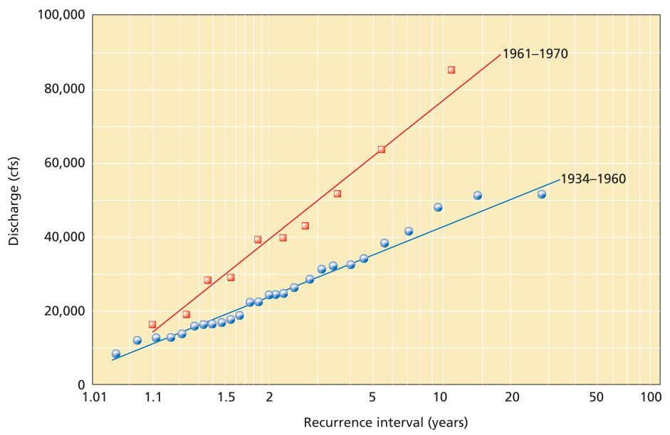
Flood frequency curve for two different periods of different climates, along a river in Africa. The recurrence time (horizontal axis) represents how often a flood with a specific volume of water (vertical axis, showing discharge in cubic feet per second) occurs at a location along a river. Note that the river had a dry climate from 1934 to 1960, and floods were not as large or as frequent as in the wetter period from 1961 to 1970. Changes in climate can severely impact the predicted frequency of floods
River Floods and Flood Frequency Analysis. Seasonal variations in precipitation patterns directly influence stream discharge, causing water levels to rise and occasionally exceed the natural banks of river channels. During flood events, both discharge and flow velocity increase substantially, enabling streams to transport larger sedimentary particles than under normal flow conditions. The most significant geomorphic modifications to river channels frequently occur during flood episodes, including the formation of new meander cutoffs, establishment of alternative channel pathways, breaching of natural levee systems, and, in extreme cases, complete abandonment of existing channels in favor of more efficient flow routes. Flood events exhibit predictable recurrence patterns, with recurrence intervals representing the statistical probability of floods of specific magnitudes occurring over time. Smaller-magnitude floods manifest with relative frequency, typically on an annual basis, while larger flood events occur less regularly, and the most extreme floods demonstrate the longest intervals between occurrences. The recurrence interval, commonly expressed through statistical metrics such as the 50-year flood, 100-year flood, and 500-year flood, provides a probabilistic framework for understanding flood frequency and assists planners in making informed decisions about floodplain development.
Flood frequency curves can be constructed for individual streams and rivers by plotting discharge measurements against recurrence intervals, establishing characteristic flooding patterns unique to each watershed. Understanding the probability that a flood of specific magnitude will occur within a given timeframe represents essential information for residents, property owners, and municipal planners operating within floodplain environments. For example, if a community experienced inundation from a flood measuring 150 cubic feet per second (4.25 cubic meters per second) that deposited 10 feet (3 meters) of water three decades ago, planners must evaluate whether current development proposals for adjacent floodplain areas are prudent. Through application of flood frequency analysis, planners can determine that floods of this magnitude statistically occur approximately every 40 years, while events of double that magnitude are expected on a centennial basis. Armed with this information, responsible planning and insurance professionals can conclude that extensive floodplain development represents an unacceptable risk, recommending instead that new communities be established on elevated terrain.
Understanding flood frequency and the probability of specific-magnitude flood events is also essential for engineering design and land-use planning across multiple sectors. Civil engineers must calculate appropriate capacities for bridge structures and drainage infrastructure, determining the hydrological parameters that such structures must accommodate while developing comprehensive land-use strategies for floodplain regions. In many circumstances, investing in larger, more robust bridge infrastructure proves justified despite the apparent improbability of small streams reaching elevations that would necessitate such substantial structures. Conversely, when structures are designed with limited operational lifespans, planners must evaluate whether flood probability justifies the additional investment required for flood-resistant construction methods.
Coastal Storms and Storm Surge Dynamics. Coastal regions affected by tropical cyclones and hurricanes face significant flooding threats from associated storm surges, which represent one of the most dangerous and unpredictable hazards for coastal populations. Storm surges develop when low-pressure systems push water ahead of moving storms, creating exceptionally high tidal conditions that precede severe oceanic storms. These phenomena constitute primary hazards for communities situated along coastlines worldwide.
When hurricanes, cyclones, or extratropical low-pressure systems (commonly known as coastal storms or northeasters) develop, their rotational dynamics and central low-pressure zones elevate water levels by several to tens of feet (less than 1 to 10 meters). This elevated water mass advances ahead of the storm system as a storm surge, representing additional water height beyond normal tidal variations. Wind forces contribute additional elevation to the surge, with total surge height determined by multiple factors including wind duration, fetch length, wind direction, and the central pressure minimum within the storm system. The most destructive storm surge events occur when these phenomena coincide with astronomically high tides, as the combined effects of surge and regular tidal patterns produce cumulative inundation impacts.
Statistical probability models enable prediction of storm surge events of specific heights affecting coastal segments within defined time intervals. When surge height is plotted on semilogarithmic coordinates, with height represented on a linear scale and frequency (in years) on a logarithmic scale, a linear relationship emerges. This statistical relationship allows coastal communities to plan for storm surges of particular magnitudes to occur approximately once within specified intervals, typically calculated for 50-year, 100-year, 300-year, or 500-year events, although precise timing remains unpredictable. These calculations represent long-term statistical averages; multiple 500-year events may cluster within relatively brief periods, but over extended timeframes, the frequency averages to once per 500 years.
During major hurricanes and coastal storms, the greatest destruction and highest mortality rates typically associate with storm surge inundation. Rising waters can cover extensive regions, maintaining elevated levels for extended periods during intense storms, resulting in drowning deaths in low-lying areas while waves advancing atop the surge continuously impact structures with destructive force.
Bangladesh: A Case Study in Storm Surge Vulnerability. Bangladesh experiences the most frequent and destructive storm surges globally, representing an exceptionally vulnerable region due to its geographic and demographic characteristics. This densely populated, low-lying nation sits predominantly at or near sea level between India and Myanmar, occupying a delta environment formed by sediment deposition from the Ganges and Brahmaputra Rivers, which erode from the Himalayan mountain range. Bangladesh experiences regular flooding from elevated river levels, with up to 20 percent of its territory submerged annually. The country lies directly within the path of numerous Bay of Bengal tropical cyclones and has experienced eight of the ten deadliest hurricane disasters in recorded history, including Typhoon Sidr in late 2007.
The Bhola cyclone of November 12-13, 1970, a Category 3 typhoon, struck Bangladesh with winds of 115 miles per hour (185 kilometers per hour) and generated a 23-foot (7-meter) storm surge that coincided with astronomically high tides during a full moon. The resulting devastation claimed approximately 500,000 human lives along with comparable numbers of livestock. Accurate death toll estimates for this rural region vary considerably, ranging from 300,000 to 1 million fatalities from this single storm event, with most deaths resulting from the storm surge that inundated low-lying deltaic islands in the Ganges River system. Tazmuddin Province experienced the most severe impacts, where nearly half of Thana city's 167,000 residents perished. Another devastating cyclone struck the same region in 1990, generating a 20-foot (6.1-meter) storm surge with 145-mile-per-hour (233.4-kilometer-per-hour) winds, claiming an additional 140,000 lives and half a million farm animals. In November 2007, Bangladesh experienced Typhoon Sidr, a powerful Category 5 cyclone with 150-mile-per-hour (242-kilometer-per-hour) winds and a 20-foot (6-meter) storm surge. Improved warning systems implemented since 1990 enabled more effective evacuations from low-lying areas, yet estimated fatalities still ranged from 5,000 to 10,000 people, primarily due to storm surge effects.
Flash Floods: Rapid-Onset Inundation Events. Flash floods develop from concentrated periods of intense rainfall and occur commonly in regions near warm ocean waters, along steep mountain fronts exposed to moisture-laden winds, and in areas prone to severe thunderstorm activity. These rapid-onset flood events are particularly well-documented in the mountain and canyon regions of the southwestern United States and numerous other global locations. The Balcones escarpment in Texas has recorded some of the most intense rainfall events in the United States, where atmospheric instability frequently develops along the boundary between dry desert air masses from the northwest and warm, moist air rising from the Gulf of Mexico to the south and east. This meteorological configuration has produced rainfall accumulations of up to 20 inches (0.5 meters) within three-hour periods. The escarpment also traps tropical cyclone moisture, as demonstrated by Hurricane Alice in 1954, which deposited more than 40 inches (102 centimeters) of rain, generating floodwaters 65 feet (20 meters) deep—among the largest floods ever documented in Texas. Approximately 25 percent of catastrophic flash flood events in the United States have occurred along this escarpment.
The national record for highest single-day rainfall belongs to south Texas, where Hurricane Claudette deposited 43 inches (1.1 meters) of rain on the Houston area in 1979. The region experienced another devastating flood event during June 8-10, 2001, when an early-season tropical storm rapidly intensified off the Galveston coast, delivering 28-35 inches (0.7-0.9 meters) of rain to Houston and surrounding areas. This flood ranked among Houston's worst disasters, leaving 17,000 people homeless and claiming 22 lives. More than 30,000 laboratory animals perished in local hospital and research facilities, while university and hospital research laboratories sustained hundreds of millions of dollars in damage. Authorities allocated $50 million to purchase properties from homeowners who had developed on particularly hazardous floodplains, while total damages exceeded $5 billion. Standing water left by the floods created breeding grounds for disease-carrying mosquitoes, while elevated humidity led to dramatically increased mold spore release, causing allergic reactions in susceptible individuals and toxic effects in others.
The Cherrapunji region in southern India, situated at the base of the Himalayan Mountains, has recorded the world's highest rainfall totals. Moist air masses from the Bay of Bengal move toward Cherrapunji, where they encounter the rising Himalayan terrain, producing a strong orographic effect whereby ascending, cooling air masses release their moisture as intense precipitation. Cherrapunji received 30 feet (9 meters) of rain in a single month (July 1861) and more than 75 feet (23 meters) for the entire year of 1861.
Flash floods typically occur in localized areas where mountainous terrain induces atmospheric uplift, generating massive convective thunderstorms that can deliver several inches of rainfall per hour onto steep terrain, which concentrates runoff into narrow, steep-walled canyons. The resulting floodwaters can be terrifying, thundering through canyons with destructive force, eroding landscapes in arid, sparsely vegetated regions while causing less geomorphic change in well-vegetated areas. Many mountain canyons have extensive upstream drainage basins, and storm systems generating flash floods may be located so remotely that canyon occupants remain unaware of both the precipitation event and their imminent danger. Multiple factors beyond rainfall amount influence flash flood severity, including drainage basin morphology, which determines rainfall convergence rates; antecedent soil moisture conditions; vegetation cover; urbanization extent; and slope gradients.
Big Thompson Canyon Flood of 1976. Big Thompson Canyon, a popular recreation area approximately 50 miles (80 kilometers) northwest of Denver in Colorado's Front Range, experienced a catastrophic flash flood on July 31, 1976. A massive thunderstorm developed over the Front Range, producing an unexpected cloudburst that deposited approximately 7.5 inches (0.2 meters) of rain within four hours—an amount roughly equivalent to the area's average annual precipitation. The steep topography concentrated runoff into Big Thompson Canyon, generating a flash flood with a 20-foot (6-meter) wall of water that surged through the canyon narrows at 15 miles per hour (24 kilometers per hour), killing 145 people traveling through the canyon. Survivors abandoned their vehicles and scrambled up canyon walls to safety, watching their cars wash away. Those who escaped by climbing canyon walls survived, while others perished in the flood. Beyond the fatalities, this flash flood destroyed 418 homes, wrecked 52 businesses, and washed away 400 vehicles, with total damage estimated at $36 million.
Flash Floods in the Northern Oman Mountains. The Northern Oman (Hajar) Mountains constitute a steep, rugged range on the northeastern Arabian Peninsula, featuring deep, elongated canyons that discharge into the Gulf of Oman and Arabian Sea. These normally dry canyons, known locally as wadis, serve as locations where villagers dig wells to access groundwater for domestic and agricultural use. Although the region typically experiences arid conditions, infrequent thunderstorms occasionally develop over portions of the mountains, and typhoons may traverse from the Indian Ocean across the Arabian Peninsula, depositing exceptional rainfall. During such events, the canyons become extremely hazardous, and local oral traditions recount flash floods with hundred-foot (30-meter) walls of water that have destroyed entire settlements, leaving only coarse gravel deposits.
Residents have adapted by constructing villages on elevated escarpments above the wadis, safe from rare but devastating floods. Evidence of older destroyed villages remains visible in some wadi floors, but generational wisdom gained from experiencing catastrophic floods has encouraged relocation to higher ground. Communities address the inconvenience of being situated hundreds of feet above water sources by constructing long aqueduct systems called falaj, which convey water from upstream sources at similar elevations through gravity-fed channels. In August 2007, Typhoon Gonu caused severe flooding across northern Oman, with floodwaters surging through mountain canyons and inundating Muscat streets with 5-10 feet (1-3 meters) of water, causing extensive damage to homes and businesses, requiring motorboat rescues from flooded desert streets.
Flash Floods in the Southern Alps and Algeria. In November 2001, parts of Algeria in North Africa experienced two days of heavy rainfall that triggered the worst flooding and mudslides in Algiers in over four decades. An estimated 1,000 people perished in Algiers, buried by rapidly moving mudflows that swept from the Atlas Mountains south of the city, particularly devastating the Bab El Oued District, one of the poorest neighborhoods, where 600 people were buried under mudflows several feet (1 meter) thick. These events followed similar heavy rains and mudslides that devastated parts of southern Europe in October 2000, with northern Italy and Switzerland experiencing the most severe impacts, where water levels reached their highest in 30 years, killing approximately 50 people. In Switzerland, the southern mountain village of Gondo was devastated when a 120-foot (37-meter) wide mudflow tore through the town center, removing 10 homes (one-third of the village) and killing 13 people. Numerous roads, bridges, and railroads were washed away throughout the region extending from southern France through Switzerland and Italy to the Adriatic Sea, while agricultural losses were massive, tens of thousands of people required evacuation, and total damage estimates reached billions of dollars.
Regional Flood Disasters: Large-Scale Inundation Events. Some flooding events achieve massive scales, inundating hundreds of thousands of acres along entire river system floodplains. These floods typically develop gradually and may maintain elevated water levels for weeks or even months. Historical records demonstrate that many levees fail during prolonged regional flooding because these structures are typically designed to withstand high water for limited durations. Extended high water periods allow sustained hydrostatic pressure to force water into levee pore spaces, causing seepage through and beneath structures, often resulting in catastrophic failure. Long-term flooding events can affect hundreds of thousands or millions of people, causing widespread disease outbreaks, famine conditions, employment disruption, and population displacement. Floods of such magnitude rank among the most costly of all natural disasters.
Mississippi River Basin Floods. The Mississippi River represents the largest river basin in the United States and the third-largest globally, experiencing frequent and sometimes devastating flood events. All 11 major Mississippi tributaries have experienced major floods, including events that at least quadrupled normal river discharge in 1993, 1973, 1927, 1909, 1903, 1892, and 1883. Three major rivers—the Mississippi, Missouri, and Illinois—converge at St. Louis, which has experienced some of the most severe flooding along the entire system. Floods during the 1700s and 1800s prompted establishment of the Mississippi River Commission, which supervised construction of extensive levee systems along much of the river from New Orleans to Iowa. By 1926, over 1,800 miles (2,896.8 kilometers) of levees had been constructed, many exceeding 20 feet (6.1 meters) in height. These levees created a false sense of security against Mississippi floodwaters while simultaneously restricting the channel, causing floods to rise more rapidly and flow faster than under natural conditions.
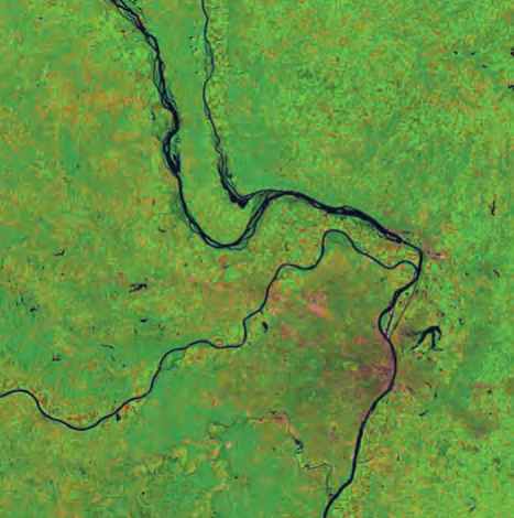
Satellite image of the St. Louis, Missouri, area that shows the Mississippi, Missouri, and Illinois Rivers at normal flow stages (Image taken August 14, 1991; NASA images created by Jesse Allen, Earth Observatory, using data provided courtesy of Landsat Project Science Office)
Prolonged rainfall in late fall 1926, combined with high winter snowmelt in the upper Mississippi basin, caused the river to reach alarming levels by spring 1927. Concerned residents strengthened and heightened levees along the river in attempts to prevent disaster. As the flood crest moved through the upper Midwest toward central Mississippi with continued rainfall, levees began collapsing in April, releasing torrents of water across thousands of acres of farmland, destroying homes, killing livestock, and displacing 50,000 people. Washington County, Mississippi, experienced particularly severe impacts when an intense late April storm delivered 15 inches (457.2 centimeters) of rain in 18 hours, causing additional levee failures.
The Mounds Landing levee collapse on April 22 sent a 10-foot-deep lobe of water across Washington County's town of Greenville. The river expanded to 50 miles in width, flooding approximately 1 million acres and destroying an estimated 2,200 buildings in Washington County alone. Many people died attempting to prevent levee failures, swept away in the deluge. Floodwaters remained high for over two months, forcing residents to either evacuate or live in crowded, unsanitary refugee camps on levees. An estimated 1,000 people perished in the 1927 floods—some from initial inundation, more from famine and disease in subsequent months. Over 1 million people were displaced, 27,000 square miles (43,450 square kilometers, or 16.6 million acres) were flooded, crop losses reached $102.6 million, and 162,000 homes were inundated.
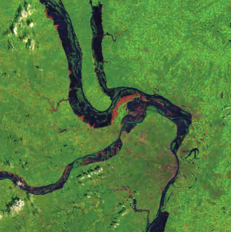
Satellite image of the St. Louis, Missouri, area that shows the Mississippi, Missouri, and Illinois Rivers at stages at the height of the 1993 flood (Image taken August 19, 1993; NASA images created by Jesse Allen, Earth Observatory, using data provided courtesy of Landsat Project Science Office)
Another wet period occurred along the Mississippi in 1972, with most tributaries and reservoirs reaching capacity by summer's end. Continued rainfall through winter 1972-73, combined with thickening snowpack over the northern Mississippi basin, caused the river to reach flood levels at St. Louis in early March, even before snowmelt completion. Heavy rain persisted throughout the Mississippi basin, and the river continued rising through April and May, spilling into fields and low-lying areas. The Mississippi rose to over 50 feet above average levels throughout much of the lower basin, causing smaller tributaries to back up to comparable elevations. Floodwaters reached levels unseen for 200 years. At Baton Rouge, Louisiana, the river nearly breached its banks to establish a new course to the Gulf of Mexico, which would have left New Orleans without river access. Floodwaters began peaking in late April, with 30,000 people evacuated from St. Louis by April 28 and nearly 70,000 from the region. The river remained at record heights throughout the lower drainage basin through late June, with damage estimates exceeding $750 million (1973 dollars).
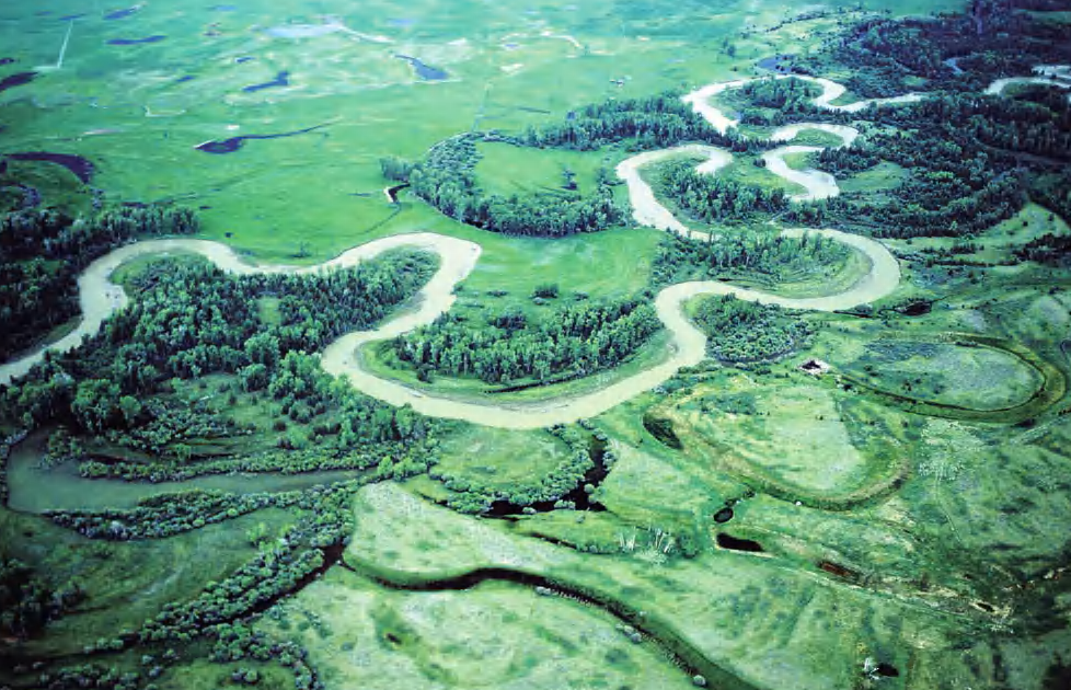
The Blackfoot River in Montana, showing natural meanders, oxbow lakes, and floodplain
In late summer 1993, the Mississippi and its upper basin tributaries rose to levels not observed in over 130 years. Discharge at St. Louis exceeded 1 million cubic feet (28,320 cubic meters) per second. The meteorological conditions causing these floods closely resembled those of 1927 and 1973 but were more severe. High winter snowmelt was followed by heavy summer rainfall caused by a low-pressure trough that stalled over the Midwest, blocked by a stationary high-pressure ridge over the eastern United States. The low-pressure system drew moist Gulf of Mexico air that encountered cold air from the eastern high-pressure ridge, generating heavy rainfall throughout much of the summer. Rivers continued rising until August, reaching unprecedented flood heights. Mississippi discharge reached record levels, and water heights were further exacerbated because levees restricted lateral water spreading, causing more rapid elevation increases than would have occurred without levee systems. Over two-thirds of all levees in the upper Mississippi River basin were breached, overtopped, or damaged during the 1993 floods. Forty-eight people died, 50,000 homes were damaged or destroyed, and total damage costs exceeded $20 billion.
The examples of Mississippi floods in 1927 and 1993 demonstrate the dangers of extensive levee construction along rivers. Levees adversely affect natural river processes and can actually worsen flood impacts. Their first effect is confining rivers to narrow channels, causing water to rise faster than if allowed to spread across floodplains. Additionally, because water can no longer flow across floodplains, ground infiltration is reduced, forcing water that would normally be absorbed through floodplain soils into confined river channels, thereby increasing flood magnitudes. A third hazard involves levee failure mechanisms. When levees break, they fail under tremendous force from hundreds or thousands of acres of elevated river water pushing from behind. The force of water that breached Mounds Landing Levee during the 1927 flood was estimated equivalent to water flowing over Niagara Falls. Without levees, water would rise gradually, causing significantly less catastrophic impacts when eventually entering farmland and towns along the Mississippi River basin.
Yellow River, China: The River of Sorrow. More people have died from floods along China's Yellow River than from any other natural feature, whether river, volcano, fault system, or coastline. Millions have perished from floods and resulting famine generated by the Yellow River, earning it the designation "River of Sorrow" in China. The Yellow River flows from the Kunlun Mountains across much of China into the extensive lowland basin between Beijing and Shanghai. The river has shifted its lower course at least 10 times during the past 2,500 years, currently flowing into Chihli (Bohai) Bay and then into the Yellow Sea. Chinese efforts to control and modify the Yellow River's course date back to dredging operations in 2356 B.C.E. and levee construction in 602 B.C.E.
One of the most severe modern floods along the Yellow River occurred in 1887, when the river overtopped 75-foot (22-meter) high levees and inundated lowlands, resulting in over 1 million deaths from floods and subsequent famine. Crops and livestock were destroyed, and sorrow returned to the river. The Yellow River was also the site of a mixed natural and unnatural disaster in 1938 when, during wartime, Nationalist Chinese leader Chiang Kai-shek reportedly ordered attacks on Yellow River levees to halt advancing Japanese forces. The Japanese army had been advancing inland from the coast, and Chinese forces adopted a scorched earth policy, burning towns and villages before retreating. When Japanese forces arrived at Xuzhou in Jiangsu Province on May 20, 1938, they found the area deserted. However, torrential rains were causing flooding along the Yellow and Yangtze Rivers, slowing Japanese progress. In June, levees along the Yellow River were breached—whether by human action or natural failure remains debated by historians—triggering one of the river's greatest floods. The river initially inundated 500 square miles (1,295 square kilometers), and floodwaters spread throughout June and July with continued rainfall, claiming an additional 1 million lives. Despite enormous loss of life and destruction, the massive Yellow River and Yangtze River floods forced Japanese forces into a disorganized retreat by raft and boat. The Japanese subsequently attempted to advance up the Yangtze, capturing towns including Jiujiang in Jiangxi Province with great loss of life. On August 3, Chinese forces cut Yangtze River dikes, causing additional flooding and loss of life but effectively ending the Japanese two-month advance up the Yangtze. By mid-August, Japanese forces were retreating from their central China advance, following floodwaters to the sea.
The Yellow River continues its natural process of bed aggradation, and riverside residents continue raising levee heights to protect fields from flooding. Today, the river bottom rests an astounding 65 feet (20 meters) above the surrounding floodplain, demonstrating the river's persistent attempts to find a new, lower channel through avulsion. The question remains: if heavy rains cause another serious flood along the River of Sorrow, will another million people perish?
Urbanization and Flash Flooding Impacts. Urbanization transforms natural habitats and environments through construction and population concentration, fundamentally altering how these systems respond to hydrological inputs. When heavy rainfall occurs in unaltered natural environments, the land surface responds through various mechanisms that accommodate additional water. Desert regions may experience severe erosion from raindrop impact that dislodges soil particles, combined with overland flow during intense rainfall, causing upland channel enlargement to accommodate larger floods. Areas receiving frequent heavy rainfall typically develop lush vegetative cover that buffers raindrop impact and reduces soil erosion, while extensive root systems stabilize soil against overland flow erosion. Stream channels in such environments may be sufficiently large to accommodate high-volume flood events.
When natural systems are altered in urban areas, dangerous consequences can result. Many municipalities have paved substantial portions of drainage basins, covering recharge areas with roads, buildings, parking lots, and other impervious structures. Consequently, water that previously infiltrated into groundwater systems now flows overland into stream channels, which may themselves be modified or even paved. The net effect of these alterations is that flash floods may occur much more frequently than under natural conditions, since more water enters stream systems than before alteration. Floods may also occur with significantly lower rainfall amounts, and because water flows overland without infiltrating into the ground, flash floods may reach urban areas more quickly than before stream system modifications. Overall, urbanization produces faster, stronger, larger floods with greater erosive power and more damaging potential, almost as if the natural environment responds to urban growth by intensifying its capacity to restore natural conditions.
Missouri River Floodplain Modifications. The Missouri River extends over 2,300 miles and drains one-sixth of the United States, once representing one of the most wild stretches of rivers in the American Midwest. Over the past two centuries, the Missouri, along with its adjacent wetlands and floodplains, has been dramatically modified through various attempts to promote transportation, agriculture, and development. These modifications have included wetland drainage for cultivation, stream channel straightening to facilitate navigation, bank stabilization to prevent erosion, and construction of agricultural levees, dams, reservoirs, and flood-control levees to regulate water flow and exclude floodwaters from floodplains. These modifications have resulted in severe wetland loss. Historically, the Missouri River floodplain below Sioux City, Iowa, covered 1.9 million acres.
According to the Sierra Club, modifications to the river-floodplain system have resulted in loss of approximately 168,000 acres of natural channel, 354,000 acres of meander belt habitat, and 50 percent of the river's surface area. Additionally, shallow-water habitat has been reduced by up to 90 percent in some areas, while sandbars, islands, oxbows, and backwaters have been virtually eliminated. Forested floodplains along the Missouri decreased from 76 percent in the 19th century to 13 percent by 1972, while cultivated lands increased from 18 to 83 percent. By the late 1970s, the lower Missouri River had been completely channelized, and its natural floodplain ecosystems had been almost entirely converted to agricultural or other uses. Today, levees and other flood-control structures flank the lower Missouri River for most of its length. Environmental organizations including the Sierra Club, Great Rivers Habitat Alliance, and Ducks Unlimited continue opposing further floodplain development to prevent complete habitat loss and reduce hazardous flood risks along the system.
Summary and Conclusions. Floods represent the costliest, deadliest, and most common natural disaster affecting human populations. Individual flood events have killed approximately one million people at a time, while other floods cause billions of dollars in damages, destroy entire communities, disrupt hundreds of thousands of livelihoods, and introduce disease and famine to affected regions. Multiple flood types exist, ranging from localized flash floods sweeping through isolated mountain canyons to coastal floods associated with tropical cyclones and major ocean storms. Bangladesh has experienced the most frequent and deadly storm surge-related flooding globally, with some storms killing hundreds of thousands of people. History's most devastating floods include large, slowly rising events that inundate entire regions, with China's Yellow and Yangtze Rivers holding the dubious distinction of recording the two deadliest floods in recorded history, each claiming over one million lives. Floods along the Mississippi-Missouri-Ohio River basins in the United States have been frequent and long-lasting, causing extensive damage to floodplain areas developed for commercial and residential uses. Had these areas remained natural or been utilized for agriculture, flood damage would have been substantially reduced, and river flood magnitudes would have been lower. Levees along these rivers have progressively constricted channels, raising base levels and consequently elevating river flood stages, leading to more disastrous flood outcomes.
Humans have modified rivers and floodplains for navigation and flood control for thousands of years, often with disastrous results. In the United States, Mississippi River levee construction began essentially with western settlers' arrival in the New Orleans area. Repeatedly, levees were built, floods seemed to increase in magnitude, and levees were breached or collapsed through processes of underseepage, piping, scouring, or liquefaction. Scientists observed that as levees were built higher, river beds appeared to aggrade or rise as well. However, 250 years passed before quantitative evidence demonstrated that levee construction and other flood-control measures constrict rivers, causing flood stages to rise higher and faster, becoming more dangerous with increasing levee confinement. This understanding has yet to reach policy implementation levels in the United States, where rivers continue to be actively constricted by levees, and floodplains remain extensively developed. Urbanization of floodplains also causes floods to rise faster, become more powerful, and cause greater damage than under natural conditions. Some regions, such as the American Southwest and parts of the Middle East, have extensively altered natural drainage networks to provide drinking and irrigation water in arid and semiarid climates. These water resources are currently extremely stressed and approaching their limits, yet populations continue expanding at alarming rates, necessitating new water sources to meet growing global population demands.
Date added: 2026-04-26; views: 175;