Eolian Processes and Landforms: Wind-Driven Sediment Transport in Desert Environments
The term eolian (or aeolian) derives from Aeolus, the ancient Greek god of the winds, and refers to sedimentary processes and deposits shaped by wind action. Loess represents fine-grained, windblown silt and dust that accumulates as extensive blanket deposits across continental surfaces, with particularly thick formations preserved in regions such as Shanxi Province in China. Wind also mobilizes sand into dynamic features including sand dunes, which aggregate into expansive dune fields, sand sheets, and vast sand seas (ergs) that characterize many of Earth’s desert environments.
When wind traverses a land surface, it generates turbulent airflow that exerts aerodynamic lift on loose, unconsolidated sediment. As wind velocity increases, air currents gain capacity to lift and transport progressively larger sedimentary grains, initiating a cascading process where transported particles impact the surface and dislodge additional grains. This chain reaction produces large-scale sediment transport through a mechanism known as saltation, wherein particles follow arched trajectories in a series of jumps or bounces across the surface.
The kinetic energy of windborne particles imparts significant geomorphic effects upon impacted surfaces through two principal mechanisms: abrasion and deflation. Wind erosion operates through these fundamental processes, which collectively sculpt desert landscapes over geologic timescales. Deflation describes the lifting and removal of fine particles from an area, resulting in progressive lowering of the land surface. Abrasion occurs when wind-transported sand and dust particles impact exposed surfaces, effectively functioning as a natural sandblasting process that erodes and modifies rock formations.
Yardangs constitute distinctive streamlined, elongate ridges sculpted by wind erosion, exhibiting forms that resemble the inverted hull of a ship protruding from a water surface. These geomorphic features develop through sustained abrasion concentrated along preferential airflow corridors, where windborne particles systematically erode softer materials while leaving more resistant rock ridges intact. The eroded material generated during yardang formation subsequently contributes to the downwind sediment budget, eventually forming deposits of sand, silt, and dust that further influence regional eolian processes.
Deflation operates as a significant landscape-modifying process across unvegetated terrains, where sustained wind removal has excavated substantial topographic depressions known as deflation basins. In North America, deflation basins extend as elongate depressions measuring several kilometers in length from Texas northward into Canada, though they typically attain depths of only 1 to 3 meters (3–10 feet). In contrast, deflation basins within the Sahara Desert may reach depths of several hundred meters, demonstrating the considerable variability in scale that deflational processes can achieve under different environmental conditions.
The capacity for wind deflation to transport sediment away from source areas is fundamentally constrained by wind velocity, which rarely exceeds several tens of miles per hour, limiting transport to smaller particle sizes. As deflation removes fine-grained material, larger particles including boulders and cobbles become concentrated at the surface, forming a lag deposit known as desert pavement. These pavements represent stable, long-term desert surfaces that exhibit relative durability under natural conditions; however, anthropogenic disturbance—such as vehicle traffic across the coarse surface—can disrupt this stability. When the pavement surface is broken, underlying sands become re-exposed to wind action, initiating renewed sediment transport and potentially activating entire dune systems.
Sand dunes represent locally significant landforms within desert environments, with wind constituting one of the most influential geomorphic agents shaping arid landscapes globally. The mobility of shifting sands poses severe geologic hazards in many desert and desert-margin regions, where advancing dune fronts encroach upon inhabited areas, progressively burying agricultural lands, settlements, and infrastructure beneath accumulations of sand. This phenomenon reflects a global challenge associated with desert expansion and land degradation.
Sand Dune Morphology and Dynamics. Sand dunes comprise geometrically regular mounds or ridges of sand that develop across diverse geological settings, including both desert interiors and coastal environments. Despite popular depictions portraying deserts as vast expanses of towering dunes, sandy terrain actually constitutes a minority of desert surfaces; for example, only approximately 20 percent of the Sahara Desert is covered by sand, with the remainder consisting of rocky, pebbly, or gravel-dominated surfaces. Research from the Institute of Desert Research in Lanzhou, China indicates that migrating sand dunes from the Gobi Desert encroach upon approximately 950 square miles (2,500 km²) annually within China alone, generating economic losses estimated at $6.7 billion per year and affecting an estimated 400 million residents.
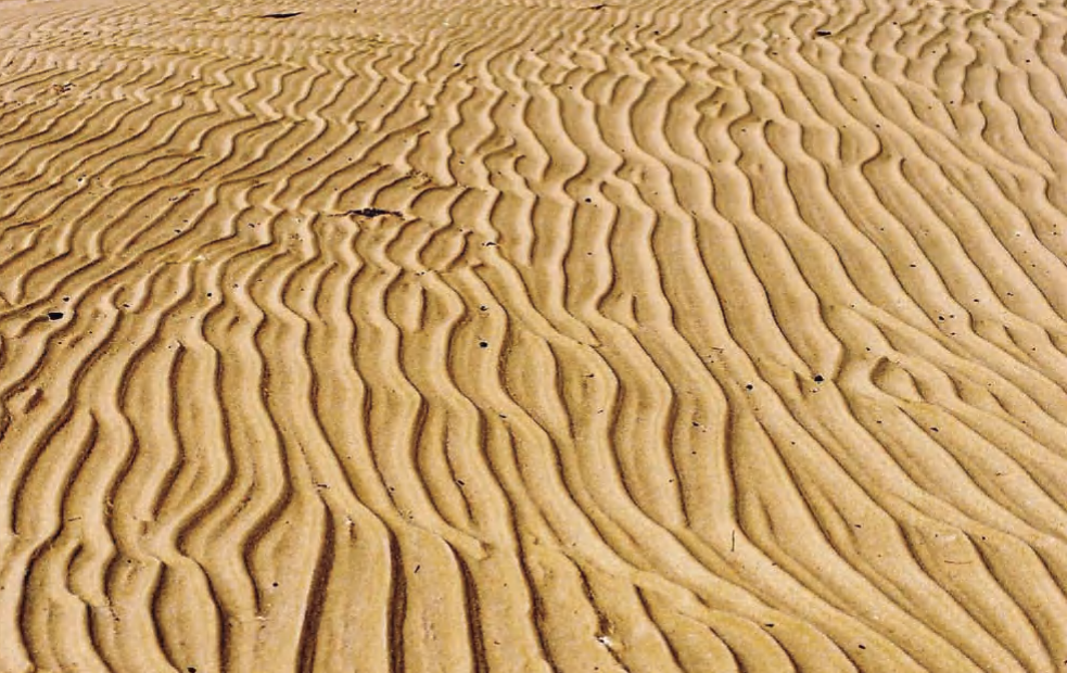
Sand rippled by wind in the Qatari Desert
Wind transports sand grains through saltation, wherein particles follow arching trajectories characterized by a series of bounces or jumps near the surface—a phenomenon readily observable on beach or desert dune surfaces. Through this transport mechanism, wind sorts sedimentary particles by size, forming elongate, small-scale features known as sand ripples, which parallel analogous structures found in stream environments. Sand dunes represent substantially larger bedforms, attaining heights up to 1,500 feet (approximately 0.5 km), and consist of mounds or ridges constructed from wind-deposited sand. Dune formation may initiate where topographic obstacles distort or obstruct airflow, though dunes may also migrate freely across desert surfaces.
All dunes exhibit asymmetrical profiles characterized by a gentle stoss slope oriented into the prevailing wind and a steeper lee slope facing away from the wind direction. Sand grains ascend the windward slope via saltation until they approach the dune crest, where diminished airflow velocity reduces transport capacity, causing particles to accumulate. Subsequently, sand avalanches or slips down the leeward slip face, maintaining the slope at approximately 30° to 34°, corresponding to the angle of repose for dry sand. The asymmetry preserved in ancient dune deposits provides geologists with diagnostic criteria for reconstructing paleowind directions in Earth’s sedimentary record.
The progressive transfer of sand from the windward to leeward side drives gradual downwind dune migration, typically at rates of 80 to 100 feet per year (24–30 m/yr), though migration rates up to 350 feet per year (107 m/yr) have been documented in the Western Desert of Egypt and the Ningxia Autonomous Region of China. This continuous movement poses significant hazards as dunes encroach upon and bury houses, agricultural lands, temples, and towns situated within migration pathways.
Dune Classification and Sand Seas. Dune morphology reflects the interaction of several controlling variables, including sand supply, wind strength and directional consistency, and vegetation cover. Under conditions of abundant vegetation and minimal wind, dunes do not form. Where vegetation is sparse, sand is plentiful, and winds maintain moderate strength—conditions typical of beach environments—transverse dunes develop, characterized by crests oriented perpendicular to the dominant wind direction.
Barchan dunes exhibit crescent shapes with horns pointing downwind, forming on flat desert surfaces characterized by steady, unidirectional winds and limited sand supply. Parabolic dunes display U-shaped forms with the open end facing upwind, developing where vegetation anchors the tails of migrating transverse dunes, warping the dune into its characteristic morphology. Although parabolic dunes superficially resemble barchans, their horns point upwind rather than downwind; however, in both dune types, the steep slip face consistently faces away from the dominant wind direction. Linear dunes form long, straight, ridge-shaped features elongated parallel to the prevailing wind direction, typically occurring in deserts with limited sand supply and strong, slightly variable winds. Star dunes develop as isolated or irregular hills where wind directions vary significantly, producing complex, multidirectional forms.
Extensive desert regions covered by thick accumulations of sand encompassing multiple dune types and largely devoid of other geographic features are termed sand seas, known locally as ergs in the North African Sahara. Interdune areas within sand seas may consist of relatively flat tabular sand sheets or evaporite basins (sabkhas). Prominent sand seas include portions of the Sahara in North Africa, the Namib Desert of southern Africa, the Rub‘ al-Khali (Empty Quarter) of the Arabian Peninsula, the Great Sandy Desert of Australia, the Gobi Desert of Asia, and the Nebraska Sand Hills of the United States.
Sand seas develop where wind velocity decreases sufficiently to deposit transported sediment, a condition that may arise from multiple factors including topographic lows or barriers such as mountain ranges that intercept sand transport corridors. The Wahiba Sand Sea of Oman exemplifies this process, where the Eastern Hajar Mountains terminate northward-moving sands, while an intermittent river system at the mountain front removes sand approaching the barrier and transports it toward the Arabian Sea coast. Longshore currents subsequently carry this sand southward, where winds re-entrain beach sands into the southern Wahiba sand sheet, establishing a closed sediment circulation system resembling a sand gyre. Additional mechanisms contributing to sand sea formation include interception of drifting sand by large water bodies or transport into shifting climate zones characterized by diminished wind strength.
Bedforms within sand seas exhibit hierarchical scaling relationships, ranging from small ripples measuring several centimeters in height to typical dunes reaching approximately 100 meters (300 feet) tall, and ultimately to giant bedforms termed draa that may attain heights up to 500 meters (1,650 feet) with wavelengths spanning several kilometers. These bedforms characteristically exhibit superposition, with smaller dunes migrating across the surfaces of larger draa features while multiple sets of ripples traverse the dunes. Wind directions inferred from different bedform scales may vary systematically, with ripples recording the most recent wind events, dunes reflecting seasonal wind regimes, and draa preserving evidence of long-term basin-scale wind patterns.
Date added: 2026-04-26; views: 164;