Geology of Europe: Alpine Mountains, Caledonides, and Baltic Shield
The geology of Europe is fundamentally defined by the Alpine system in the south, a complex chain of mountains, structures, and basins stretching across southern France and northern Italy before extending eastward through the Adriatic and Aegean arcs to the Black Sea. This system ultimately connects with the Himalayan system through Turkey, having formed during the Paleozoic–Cenozoic evolution and closure of the Tethys Ocean. The Caspian Sea, situated on the northern side of this Alpine–Himalayan chain, likely represents a fragment of oceanic crust trapped during the Tethys closure. Active plate margins in southeastern Europe, including the Calabrian arc in Italy, the Hellenic arc in Greece, and the Cyprian arc, mark the continued closure of the Tethys remnants, with Turkey moving westward along the North Anatolian fault in response to the collision between Arabia and Asia.
Northwestern Europe is largely defined by the Caledonide system, a Paleozoic orogenic belt exposed across the British Isles, particularly in the Scottish Highlands, and along the northwestern Scandinavian coast. This mountain range originated during the Paleozoic evolution and closure of the Iapetus Ocean, while the Baltic shield forms a Precambrian craton in northeastern Europe. The Baltic shield is covered by thick continental and shallow marine deposits deformed around its margins, extending northward to Svalbard (Norway) and the Kola Peninsula (Russia). Geologically, the eastern boundary of Europe is marked by the Ural Mountains, which form a distinct north–south line at the edge of the vast East European Plain overlying deep sections of the Baltic shield.
Alpine Mountain Chain. The Alps form an arcuate mountain system in south-central Europe, extending approximately 497 miles (800 km) in length and 93 miles (150 km) in width from the French Riviera through southeastern France, Switzerland, southwestern Germany, Austria, and into former Yugoslavia. The snow line in the Alps lies at approximately 8,038 feet (2,450 m), with numerous peaks remaining permanently snowcapped and hosting glaciers, the longest of which is the Aletsch Glacier. A wide array of landforms, including the Matterhorn, arêtes, U-shaped valleys, erratics, and moraines, attest to extensive Pleistocene glaciation across the region.
The Alps were formed through plate collisions associated with the closure of the Tethys Ocean during the Oligocene and Miocene, though the rocks preserve a longer history of deformation extending into the Mesozoic. The closure of the Tethys Ocean was complex, involving contraction of the older Permian–Triassic Paleo-Tethys Ocean while a younger branch, the Neo-Tethys, was opening during the Triassic and later periods. Carbonate platforms in the late Triassic covered older evaporites, foundering and becoming buried under deep-water pelagic shales and cherts during the early Jurassic. Cretaceous flysch covered foreland basins associated with convergent margins, accompanied by felsic magmatism and high-grade blueschist facies metamorphism. Continent–continent collision events dominated the Eocene–Oligocene, leading to the formation of giant fold nappes, thrusts, and deposition of synorogenic flysch, with late Tertiary events characterized by late orogenic uplift, erosion, and deposition of post-orogenic molasse in foreland basins. Deformation continues to the present day, primarily related to postcollisional extension.
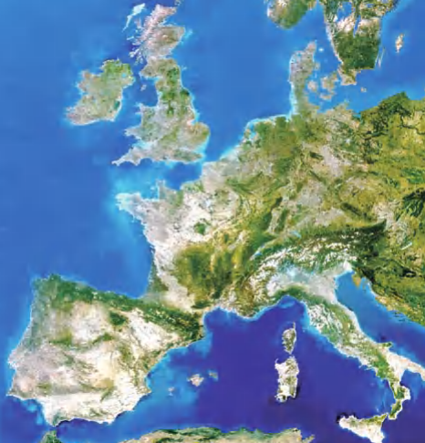
Landsat 5 satellite image of western and central Europe
Caspian Sea: Trapped Oceanic Crust. The Caspian Sea is a large, shallow, saline inland body of water bordered by southern Russia, Kazakhstan, Turkmenistan, Iran, and Azerbaijan, covering 144,444 square miles (373,000 km²) with its surface resting 92 feet (28 m) below sea level. Maximum depth reaches only 3,280 feet (1,000 m) in the south, while the northern region is extremely shallow with an average depth of 16.5 feet (5 m). Historical changes in sea level have significantly altered shoreline positions, evident in the lowland continuation of the Caspian depression in the Kalmykiya region to the northwest. The Volga River contributes more than 75 percent of the inflowing water, draining the western Ural Mountains and European plains, with additional inflow from the Ural, Emba, Kura, and Temek rivers, though the sea has no natural outlet.
The Caspian Sea is exceptionally mineral-rich, containing substantial oil and gas deposits across several regions, making it one of the world's most active exploration areas with an estimated 200 billion barrels of oil reserves. Rich petroleum deposits off the Apsheron Peninsula on the western shore led to the development of Baku, Azerbaijan, where the Nobel family, including Alfred Nobel, established their fortune in the late 19th century. Decades of Soviet-era state-run oil extraction resulted in widespread pollution and contamination, though remediation efforts have recently begun to address these environmental challenges.
The origin of the Caspian depression remains somewhat controversial, though many geologists interpret the basin as consisting largely of oceanic crust trapped during the closure of the Tethys Ocean, subsequently buried beneath thick sedimentary sequences hosting extensive petroleum deposits. The sea is also rich in salt deposits and supports a significant sturgeon fishery, though catches have declined dramatically since the early 1990s due to loss of spawning grounds, poaching, overfishing, and pollution. A single large female beluga sturgeon can reach 15 feet in length, weigh 1,300 pounds, and carry 200 pounds of roe (caviar) valued at up to $250,000 in the United States.
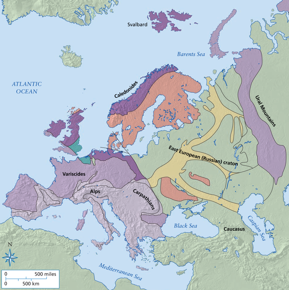
Simplified geological map of Europe showing the location of the Alps, Caledonides, East European (Russian) craton, Urals, Svalbard, and Caspian Sea
Caledonides. The Caledonides constitute an early Paleozoic orogenic belt extending across north and east Greenland, Scandinavia, and the northern British Isles, representing a continuous system with the Appalachian Mountains prior to the opening of the Atlantic Ocean. This system extends more than 4,101 miles (6,600 km) and preserves the history of the opening and closure of the Iapetus Ocean and Tornquist Sea, making it one of the most extensively studied Paleozoic orogenic belts globally. The name derives from Caledonia, the Roman designation for the region north of the Firths of Clyde and Forth, now associated with Scotland and the Scottish Highlands.
The Paleozoic Iapetus Ocean separated Laurentia (proto-North America) from Baltica and Avalonia, while the Tornquist Sea separated Baltica from Avalonia, with each continent preserving distinct faunal assemblages and paleomagnetic signatures. The eastern margin of Laurentia features Neoproterozoic and Cambrian rift basins overlain by Cambro-Ordovician carbonate platforms, representing a rifting to passive margin sequence. Baltica exhibits similar Neoproterozoic rift basins with Cambro-Ordovician shelf sequences, whereas the Avalonian margin in Germany and Poland records Neoproterozoic volcanism and deformation overlain by Cambro-Silurian shelf sequences with an Ordovician arc accretion event. Middle Ordovician ophiolites and flysch basins on both Laurentia and Baltica reflect arc accretion events with probable arc polarity reversal, leading to volcanism and thin-skinned thrusting preceding ocean closure in the Silurian.
The tectonic evolution of the Appalachian–Caledonide orogen began with rifting of the late Proterozoic supercontinent Rodinia approximately 750–600 million years ago, forming rift to passive margin sequences as Gondwana and Baltica drifted from Laurentia. Oceanic arcs collided within the Iapetus during the Cambrian and with the margins of Laurentia and Avalon during the Ordovician, producing the Taconic orogeny, ophiolite obduction, and thick foreland basin sequences. Late Ordovician and Silurian volcanism reflects arc polarity reversal and subduction beneath both Laurentia and Gondwana, rifting Avalon from Gondwana while shrinking the Iapetus. Avalonia and Baltica collided during the Silurian (430–400 million years ago), followed by collision of Gondwana with Avalon and the southern Appalachians by 300 million years ago during the Carboniferous Appalachian Orogeny, coincident with closure of the southern Rheic Ocean recorded in the Variscan Orogen of Europe.
Caledonides in the Scottish Highlands. Scotland comprises a diverse assemblage of Lower Ordovician to Archean terranes dissected by numerous northeast-trending faults forming deep valleys, with a highly irregular coastline featuring narrow to wide indented arms known as lochs and firths. The Hebrides, Orkney, and Shetland Islands lie off the northern coast, while the Southern Uplands consist of rolling, grassy hills underlain by folded and faulted Ordovician and Silurian strata separated from the Midland Valley by the Southern Uplands Fault. The Midland Valley contains thick deposits of Devonian–Carboniferous Old Red Sandstone deposited under continental conditions, separated from the Grampian Highlands by the Highland Boundary Fault. The Great Glen Fault, a late Paleozoic left-lateral fault, separates the Grampian Highlands from the Northern Highlands, where Grenvillian-age Moine and Archean Lewisian rocks are exposed, with Ben Nevis (4,406 feet; 1,343 m) standing as the highest peak.
The oldest rocks in the Scottish Highlands are the Archean (3 billion years old) through Lower Proterozoic Lewisian gneisses, formed during the Scourian tectonic cycle and found principally in the Hebrides and Northern Highlands. These late Archean gneisses include tonalitic and gabbroic types with rare ultramafic–mafic plutonic units, likely formed in a volcanic arc setting, accompanied by shallow-shelf metasedimentary rocks metamorphosed to granulite facies approximately 2.7 billion years ago. The Inverian tectonic cycle in the early Proterozoic deformed the Scourian gneisses into steep-limbed, west-northwest-trending linear structures with retrograde amphibolite facies metamorphism, followed by intrusion of mafic dike swarms at 2.2 and 1.91 billion years ago. Laxfordian cycle events after 1.9 billion years ago include shear zone formation and granite pluton intrusion near 1.72 billion years ago.
The Moinian Assemblage consists of Middle Proterozoic (older than 730 million years) pelites and psammites complexly folded into fold interference patterns and metamorphosed to amphibolite facies. Late Proterozoic (970–790 million years old) rocks include the Stoer, Sleat, and Torridon Groups, comprising conglomerates, siltstones, and sandstones reaching thicknesses of up to four miles (6 km) deposited in fluvial or deltaic environments within fault-bounded troughs along a continental margin. The Dalradian Supergroup, exceeding 12 miles (20 km) in thickness, is divided into four groups found within the Caledonian Orogen south of the Great Glen Fault. The lowermost Grampian Group includes shallow to deep-water sandstones and graywackes, overlain by shelf rocks of the Appin Group, followed by deltaic deposits of the Lochaber Group, with the Argyll Group at the top containing a glacial tillite, limestones, and deep-water graywackes interbedded with late Proterozoic (595 million-year-old) basalts.
The Paleozoic Era in the Scottish Highlands is marked by a basal transgression of the Durness sequence of shallow-marine quartzites with Skolithos trace fossils and limestones onto the Torridonian and Lewisian gneisses, correlated with the basal Cambrian–Ordovician shelf sequence in the Appalachian Mountains. The region was affected by main phases of the Caledonian orogeny, known locally as the Athollian orogeny, during the latest Cambrian or early Ordovician, with folding and regional metamorphism related to closure of the Iapetus Ocean along the Highland Boundary Fault. An accretionary wedge in the Southern Uplands comprises imbricated slivers of Ordovician–Silurian deep-water turbidites, shales, and pillow lavas associated with continued closure of the Iapetus Ocean. The Moine thrust zone in the Northern Highlands, one of the world's classic zones of imbricate thrust tectonics, formed at the end of the Silurian, placing the Caledonian orogenic wedge over foreland rocks with well-displayed sole thrusts, imbricate splays, klippen, and windows.
The Old Red Sandstone is a Silurian–Devonian sequence of conglomerates, sandstones, siltstones, shales, and bituminous limestones up to 10,000 feet (3,048 m) thick, representing fluvial–deltaic to lacustrine deposits interpreted as a molasse sequence from erosion of the Caledonides. Carboniferous deposits in Scotland include shales, coal measures, basalts, and limestones deposited in deltaic environments, primarily within the Midland Valley. Devonian through Carboniferous sinistral strike-slip faults cut many parts of the Scottish Highlands, associated with Hercynian tectonic events in Europe and the Acadian–Appalachian orogenies.
Baltic Shield. The Baltic (Fennoscandian) Shield is an Archean craton divided into three distinct parts, with the northern Lapland–Kola province consisting of dispersed Archean crustal terranes involved in a collisional orogeny at 2.0 to 1.9 billion years ago. The central Belomorian mobile belt contains gneiss and amphibolite assemblages that experienced two major orogenic periods in the Neoarchean and Paleoproterozoic, with the Neoarchean period including crust-forming events between 2.9 and 2.7 billion years ago interpreted as subduction-related followed by collisional orogeny. The Svecofennian Orogeny at 1.9–1.8 billion years ago produced strong structural and thermal reworking through crustal stacking and thrusting, caused by overthrusting of the Lapland granulite belt onto the Belomorian belt. The Karelian Province displays no isotopic evidence for strong Paleoproterozoic reworking, forming the core of the shield with volcanic and sedimentary rocks (greenstones) and granites/gneisses formed between 3.2 and 2.6 billion years ago and metamorphosed at low-grade.
Baltic Shield on the Kola Peninsula. The Kola Peninsula occupies 50,000 square miles (129,500 km²) in northwestern Russia as an eastern extension of the Scandinavian peninsula, located on the shores of the Barents Sea with most of the peninsula lying north of the Arctic Circle. The peninsula features tundra in the northeast and taiga forest in the southwest, with winters that are atypically warm and snowy due to nearby warm Atlantic Ocean waters, while summers have long daylight hours. The peninsula is part of the Archean Baltic shield, containing medium to high-grade mafic and granitic gneisses including diorite, tonalite, trondhjemite, granodiorite, and granite. Metasedimentary schist, metapelitic gneiss, quartzite, and banded-iron formation known as the Keivy Assemblage form linear outcrop belts in the eastern part of the peninsula, with mafic/ultramafic greenstone belts and multiple generations of intrusions present. Metamorphism is primarily at amphibolite facies but reaches granulite facies locally, with complex deformation including abundant fold interference patterns and early isoclinal folds possibly associated with early thrust faults.
Baltic Shield and Caledonides on Svalbard and Spitsbergen Island. Spitsbergen is the largest island (15,000 square miles; 40,000 km²) of Svalbard, a Norwegian territory in the Arctic Ocean bounded by the Greenland Sea and the Arctic Ocean, with approximately half the island covered by permanent ice and glaciers. Deeply incised fjords rise to about 3,200 feet (1,000 m), representing the present height of a peneplain that has undergone postglacial rebound since the Cenozoic. The Svalbard archipelago preserves a complex history of Archean and younger events, broken into three main terranes separated by north–south-striking faults. The eastern terrane has a basement of Archean through Proterozoic gneisses and amphibolites overlain by psammitic and pelitic schists and marbles approximately 1,750 million years old, overlain in turn by pelites, psammites, and felsic volcanics dated at 970 million years, with a Vendian group of pelites and glacial tillites formed during the Varanger glaciation. Mid-Paleozoic tectonism related to closure of the Iapetus Ocean during the Caledonian Orogeny (locally the Friesland Orogeny) produced west-vergent fold and thrust structures in the Middle and Late Ordovician, with late tectonic batholiths intruding during the Silurian through Early Devonian.
The central terrane contains a basement of mainly Proterozoic and possible Archean igneous gneisses overlain by dolostones, Varanger tillites, and Ediacarian phyllites, followed by Cambro-Ordovician carbonates. Devonian strata exposed only in the central terrane include Old Red Sandstone facies dated by fossil fish remains, associated with sinistral transpressive tectonics forming pull-apart basins filled with conglomerates, sandstones, and shales in fluvial systems. The western terrane has Proterozoic gneissic basement overlain by Varanger tillites interbedded with mafic volcanics and overlain by Ediacarian fauna, correlating more with sequences on Ellesmere Island than elsewhere in Svalbard or Greenland. Early Ordovician deformation in the western terrane is linked with subduction tectonics that may have continued into the Late Ordovician, with later Devonian deformation possibly associated with the Ellesmerian Orogeny. Some tectonic models invoke more than 600 miles (1,000 km) of sinistral strike-slip displacement in the Silurian–Late Devonian, bringing the eastern terrane into juxtaposition with central Greenland and forming pull-apart basins filled by Old Red Sandstone in the central terrane.
From the Carboniferous through the Early Eocene, most of Svalbard experienced relatively stable platform sedimentation continuous with that of northern Greenland and the Sverdrup basin of northern Canada. Early Carboniferous deposits include anhydrites, breccias, conglomerates, sabkha deposits, and carbonates forming the basal 3,000 feet (1,000 m) of the section, grading upward into 1,500 feet (450 m) of fine-grained siliciclastic rocks, cherts, and glauconitic sandstones. Mesozoic strata exceed 8,000 feet (2,500 m) of interbedded deltaic and marine deposits, followed by a Late Cretaceous period of nondeposition and subsequent deposition of nearly 5,000 feet (1,500 m) of deltaic sandstones, shales, and marine beds in the Paleocene and Early Eocene. In the Eocene, western Spitsbergen collided in a dextral transpressional event with the northeast margin of Greenland, forming folds, thrusts, and later normal faults along the western coast, with small pull-apart basins filled by sediments derived from the contemporaneous uplifted fold belt. Erosion and peneplaination in the Oligocene through Holocene formed the flat surface evident across the archipelago today, with Quaternary glaciations depressing the crust followed by postglacial rebound and thermal uplift associated with opening of the Arctic Ocean, Norwegian Basin, and Greenland Basin. Quaternary flood basalts in the northern part of Svalbard are associated with these extensional basin-forming events.
Date added: 2026-04-26; views: 176;