Greenstone Belts: Archean Geology, Structural Evolution, and Tectonic Significance
A greenstone belt is defined as an elongate assemblage composed predominantly of mafic volcanic and plutonic rocks, frequently interlayered with sedimentary sequences such as sandstones, mudstones, and banded iron formations. Carbonates and mature sedimentary rocks occur less commonly within these successions. The majority of greenstone belts are Archean or at least Precambrian in age, although analogous sequences are documented within orogenic belts from all geologic eras. These belts have typically undergone metamorphism ranging from greenschist to amphibolite facies and are commonly intruded by diverse granitoid rocks. While older gneissic complexes are associated with some greenstone belts, they are generally in faulted contact rather than depositional continuity.
The morphology and scale of greenstone belts vary considerably, exhibiting an asymmetric distribution across Archean cratons that mirrors tectonic zonations observed in Phanerozoic orogens. For instance, the Yilgarn Craton in Australia features predominantly granitic gneisses in the southwest, extensive 2.9 billion-year-old greenstones in the central region, and younger 2.7 billion-year-old greenstones in the east. Similarly, the Slave Province in Canada preserves a complex gneissic terrain aged approximately 4.2 to 2.9 billion years in its western portion, a central domain dominated by mafic greenstone belts, and eastern sections characterized by 2.68 billion-year-old mixed mafic, intermediate, and felsic calc-alkaline volcanic rocks. This asymmetric pattern is also evident in the Zimbabwe Craton of Africa, where granitic rocks dominate the east and greenstone sequences are concentrated in the west. The Superior Province contains numerous subparallel belts extending thousands of miles, each distinct yet comparable in scale and lithology to Phanerozoic orogenic belts. Such distributions reflect asymmetric tectonic zonations typically produced by plate tectonic processes in younger orogens, suggesting that greenstone belts represent remnants of larger, once-continuous orogenic systems.
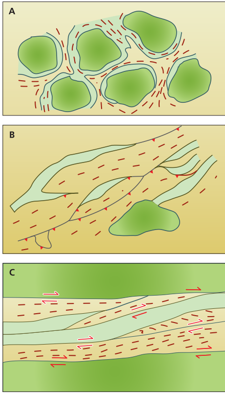
Map showing the main structural elements of greenstone belts: dark green are granites; light green are greenstones; tan are metasediments; red lines are foliations
Regional outcrop patterns of greenstone belts can be categorized into three distinct end-member types based on their distribution within cratons. The first pattern comprises broad domal granitoids with interdomal greenstones, often resulting from interference folding or the emplacement of dome-shaped granitoid plutons. The second pattern features broad greenstone terrains characterized by internally branching lithological domains and irregular granitoid contacts, exemplified by large portions of the Yilgarn Province in Western Australia and the Slave Province in Canada, where contacts with granitoids are typically intrusive. The third pattern consists of long, narrow, linear greenstone belts representing composite thrust and strike-slip belts, where one or more margins are dominated by late strike-slip shear zones, and granite-greenstone contacts are commonly defined by faults or shear zones.
Until recently, few complete ophiolite sequences were identified within Archean greenstone belts, leading to the hypothesis that Archean oceanic crustal fragments were not preserved. However, research documenting partially dismembered ophiolites in several belts and a complete ophiolite sequence in the North China Craton has challenged this view. It is now proposed that Archean oceanic crust was considerably thicker than its Proterozoic and Phanerozoic counterparts, resulting in accretion primarily of the upper basaltic section. This crustal thickness may have been analogous to modern oceanic plateaus, making the preservation of complete, Phanerozoic-style ophiolite sequences unlikely in Archean orogenies. Instead, only the upper, pillow lava-dominated sections were preferentially accreted. The abundance of accreted ophiolitic fragments within Archean greenstone belts compared to Phanerozoic orogens suggests that thick, buoyant, young Archean oceanic lithosphere possessed a structural configuration that facilitated the detachment of uppermost crustal sections during subduction and collisional events.
Geophysical surveys, including gravity and seismic reflection studies, have elucidated the subsurface geometry of greenstone belts, indicating they are predominantly shallow to intermediate in depth, typically extending between 3 to 15 miles (5–20 km). These belts often possess flat or irregular basal surfaces and are intruded by granitic rocks, contradicting the traditional model of steep synclinal keels. Gravity models consistently demonstrate that greenstone belts rarely exceed 6 miles (10 km) in depth, while seismic reflection data reveal that steeply dipping structures characteristic of these belts transition into horizontally layered mid to lower crustal architecture. Furthermore, seismic surveys have proven critical in identifying that boundaries between distinct belts within granite-greenstone terrains often correspond to large-scale crustal discontinuities, interpreted as sutures or major strike-slip faults.
Mirroring their asymmetric distribution across cratons, greenstone belts frequently exhibit internal asymmetry in rock type distribution and structural vergence, aligning them closely with younger orogenic systems. For example, the eastern segment of the Norseman-Wiluna Belt in the Yilgarn Craton contains a complex association of oceanic-type mafic and island arc-type volcanic rocks, whereas the western segment hosts disrupted rocks of predominantly oceanic affinity. A persistent misconception regarding greenstone belt structure is their interpretation as simple, steep synclinal keels of volcanic and sedimentary rocks squeezed between diapiric granitoids. Detailed structural analyses reveal a lack of stratigraphic continuity across supposed synclines and demonstrate significantly greater complexity than predicted by the pinched-synform model. Consequently, modern approaches advocate abandoning purely stratigraphic mapping methods in favor of techniques applied to gneissic terrains, dividing greenstone belts into structural domains defined by structural style, metamorphic history, distinct lithological associations, and age groupings.
One of the most remarkable characteristics of Archean greenstone belts is the prevalence of very steep to vertical structural and stratigraphic dips, indicative of intense deformation. The mechanisms responsible for this steepening vary among belts. In some, such as the central Slave Province and the Norseman-Wiluna Belt, steepening resulted from a series of thrust faults that stacked rock units end-over-end. In other regions, such as the Pilbara Craton of Australia and northern Zimbabwe Craton, the intrusion of plutons and batholiths steepened marginal rocks. Whole-crustal shortening, as observed in the Theespruit area of the Barberton Greenstone Belt on the Kaapvaal Craton, represents another significant steepening mechanism. Additionally, tight to isoclinal upright folding, fold interference patterns, and rotations associated with strike-slip or listric normal fault systems have contributed to localized steepening, mirroring structural processes active in Phanerozoic orogenic belts.
Early studies of greenstone belt stratigraphy often assumed thick successions of metamorphosed sedimentary and volcanic rocks accumulated without significant structural repetition, constructing single stratigraphic columns up to 6–12 miles (10–20 km) or more in thickness. However, the recognition of thin fault zones and precise geochronological ages documenting older rocks thrust over younger sequences necessitate a reevaluation of these thickness estimates. Intact stratigraphic sections exceeding a few miles in greenstone belts are rare. A critical observation challenging the notion of thick, primary stratigraphy is the absence of correlation between metamorphic grade and inferred stratigraphic thickness; if these sequences were genuine, a progressive increase in metamorphic grade with depth would be expected. Since this is not observed, apparent thicknesses are likely tectonic in origin, resulting from stratigraphic repetition within environments such as thrust belts or accretionary prisms, where units are stacked without a corresponding increase in metamorphic grade.
Determining the original structural relationships between greenstone belts and older gneiss terrains remains a fundamental problem. Pre-1990 studies often favored models of depositional unconformity or intrusive contacts. However, classic areas purportedly demonstrating such relationships have since been shown to contain significant early thrust faults. This has been documented at Steep Rock Lake in the Superior Province, Point Lake and Cameron River in the Slave Province, the Theespruit section of the Barberton Greenstone Belt, Belingwe in Zimbabwe, and the Norseman-Wiluna Belt. In several instances, such as at the base of the Norseman-Wiluna Belt and at Cameron River, metamorphic aureoles up to 1,640 feet (500 m) wide exhibit upper-amphibolite facies assemblages and mylonitic fabrics, contrasting with the greenschist to lower-amphibolite facies of the overlying greenstones. These aureoles are now interpreted as early shear zones related to the thrust emplacement of greenstone belts over older gneissic basement, displaying field-scale relationships analogous to those found at the base of obducted ophiolites.
The structural architecture of greenstone belts comprises multiple generations of features. The earliest structures, formed during rock deposition, include broken pillow lavas grading into breccias and possible slump folds within interpillow sediments. Early extensional faults have been identified, such as low-angle normal faults in the Barberton Greenstone Belt and sinuous shear zones in the Proterozoic Purtuniq Ophiolite. Detailed mapping has also revealed early thrust faults and associated folds, which often lack regional metamorphic fabrics, making them difficult to detect. These early thrusts are critical for juxtaposing greenstone sequences with older gneissic terrains and account for previously misinterpreted thick stratigraphic sections. Emplacement of these early thrust and fold nappes typically occurred without strong fabric development, necessitating detailed fieldwork for their recognition. Fold generations are widespread, commonly progressing from early recumbent folds associated with nappe tectonics through multiple phases of tight to isoclinal upright folds, which are linked to dominant fabric elements and metamorphic mineral growth, and concluding with late open folds or broad crustal arches.
Many granite-greenstone terrains are dissected by late-stage strike-slip faults, some of which represent reactivated structures. Large-scale lineaments, such as those within the Norseman-Wiluna Belt, exhibit consistent kinematic indicators suggesting dominant strike-slip motion. The Superior Province exemplifies this complexity, consisting of fault-bounded subprovinces with distinct lithological associations, ages, and structural histories, representing an amalgamation of oceanic crust, island arcs, continental margin arcs, and accretionary prisms assembled through dextral oblique subduction. In the southern Superior Province’s Vermillion district, deformation progressed from early nappe-style structures to main fabric elements related to dextral strike-slip and thrusting, reflecting oblique accretion. Strike-slip faults have also played a constructive role, localizing the formation of "second-cycle" greenstone belts within pull-apart basins, as documented in the Pilbara Craton. Major shear zones, such as the 186-mile (300-km) long Koolyanobbing shear zone in the Yilgarn Craton, display well-constrained kinematic histories, with mylonitic fabrics indicating significant sinistral motion.
The late stages of orogenic development in granite-greenstone terrains are characterized by extensional collapse of overthickened crust, accompanied by the intrusion of abundant granitic magmas indicative of crustal melting. Early plutons of the tonalite-trondhjemite-gabbro-granodiorite suite are generated in island arc settings, followed by continental margin arc magmas after arc collision and continental accretion. Subsequent crustal thickening triggers melting of the deep crust, producing diapiric plutons. Gravitational collapse of these thickened crustal sections, driven by the rheological properties of quartz and olivine, leads to decompression melting in the upper mantle and lower crust. This process generates basaltic melts that rise and partially melt the lower or middle crust, forming hybrid magmas that intrude as late- to post-kinematic granitoid suites. If the interval between crustal thickening and gravitational collapse is brief, these magmas may ascend through partially solidified pathways established by earlier plutons, accounting for the prevalence of composite and compositionally zoned plutons in Precambrian and younger orogenic belts.
Date added: 2026-04-26; views: 268;