The Grenville Province: Architecture of a Rodinia-Forming Orogenic Belt
Throughout Earth’s history, continental landmasses have repeatedly aggregated to form supercontinents, with Pangaea representing the most recent example, having assembled most continents between 300 and 200 million years ago. Prior to this, Gondwana formed approximately 570 million years ago, though its duration remains a subject of ongoing research. Reconstructing older supercontinents becomes progressively more challenging deeper in geological time; nevertheless, geologists have successfully identified Rodinia, a supercontinent that formed around 1 billion years ago and subsequently fragmented approximately 700 million years ago.
The Grenville Province constitutes the youngest region of the Canadian Shield, positioned outboard of the Labrador, New Quebec, Superior, Penokean, and Yavapai-Mazatzal provinces. It represents the final segment of the Canadian Shield to undergo a major deformational event—the Grenville Orogeny—which generated extensive folds and faults during the amalgamation of multiple continents that formed Rodinia. Correlative Grenvillian belts worldwide, named after the exceptional type exposures in the Grenville Province, represent deeply eroded mountain belts formed during this same collisional event. The Grenville Province covers approximately 600,000 square miles (1,000,000 km²) at the surface, though its subterranean extent is considerably broader, with Phanerozoic rocks covering its exposures from New York State along the Appalachian Mountains into Texas.
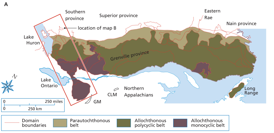
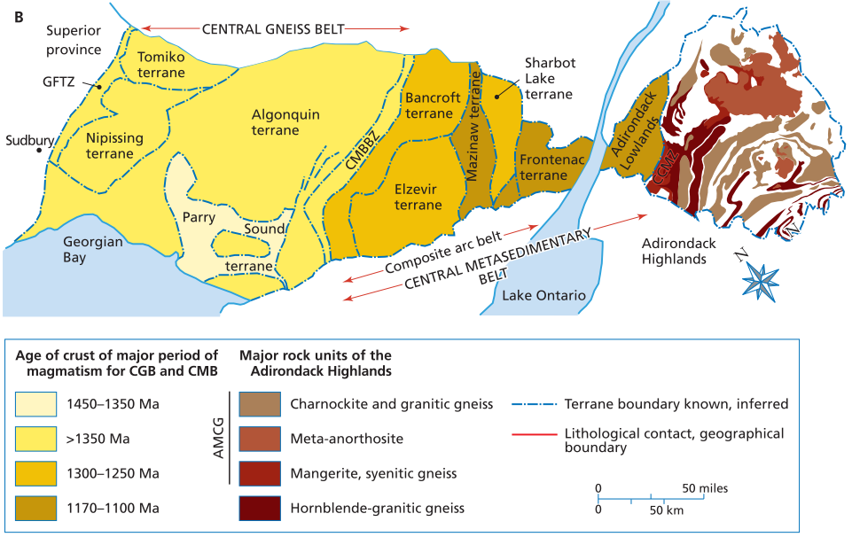
(A) Tectonic subdivisions of the Grenville province according to the classification of Toby Rivers (1989) and Carr, et al. (2000), showing also the older domain boundaries of Wynne-Edwards (1972) and others; (B) Terranes and shear zones of the central gneiss belt (CGB), the central metasedimentary belt (CMB), and major geological features of the Adirondack Highlands. Abbreviations as follows: BCS-Baie Comeau segment; CCMZ-Carthage-Colton mylonite zone; CLM-Chain Lakes massif; CMBBZ-central metasedimentary belt boundary zone; CGB-central gneiss belt; CGT-central granulite terrane; EGP-eastern Grenville province; GFTZ-Grenville Front tectonic zone; GM-Green Mountains.
The Grenville Province developed along the margin of Laurentia (the early nucleus of North America) during the middle to late Proterozoic, comprising a basement and platform sedimentary sequence subsequently intruded by igneous rocks. Following this intrusive phase, the entire region underwent high-grade metamorphism and complex deformation, though earlier tectonism included the Elsonian (1,600–1,250 Ma) and Elzevirian (1,250–1,200 Ma) orogenies. The Ottawan Orogeny, culminating at 1.1 billion years ago, represents the most intense and final deformational event, largely overprinting earlier tectonic histories and making the term Ottawan Orogeny effectively synonymous with the Grenville Orogeny. The province is subdivided into several key domains: the Central Gneiss Belt (CGB) , Central Metasedimentary Belt (CMB) , Central Granulite Terrane (CGT) , and the major structural feature known as the Grenville Front (GF) .
The Central Gneiss Belt (CGB) , located in the western portion of the Grenville Province, contains some of the region’s oldest rocks, predominantly 1.8–1.6 Ga gneisses intruded by 1.5–1.4 Ga granitic and monzonitic plutons. Both metasedimentary and igneous rocks within the CGB are metamorphosed to upper amphibolite and locally granulite facies, with a dominant northeast structural trend that shifts northwest near Georgian Bay. The CGB is bounded by the Grenville Front to the northwest and lies in tectonic contact with the Central Metasedimentary Belt to the southeast, subdivided into smaller terranes—Nipissing, Algonquin, Tomiko, and Parry Sound—based on lithology, metamorphic grade, and bounding shear zones. These terranes are predominantly parautochthonous (having experienced limited transport), with shear zones separating them exhibiting kinematic indicators consistent with northwest-directed tectonic transport between 1.18 and 1.03 Ga.
The Nipissing Terrane, occupying the western CGB, includes the Grenville Front Tectonic Zone (GFTZ) within 30 miles (50 km) of the Grenville Front, characterized by strongly deformed lithologies with northeast-striking foliations, cataclasis zones, and moderately plunging southeast lineations. Its heterogeneous gneisses comprise Archean and Lower Proterozoic migmatitic gneisses (reworked units from southern and superior provinces) alongside Middle Proterozoic metasedimentary gneisses, intruded by 1.7 and 1.45 Ga granitic plutons. Following intrusion, this terrane experienced high-grade metamorphism reaching temperatures of 1,200°F–1,280°F (650°C–750°C) and pressures of 8.0–8.5 kilobars. In contrast, the Tomiko Terrane, located in the extreme northwestern CGB, is distinguished by an abundance of metasedimentary rocks and is interpreted as allochthonous (far-traveled) based on detrital zircon populations dated at 1,687 Ma—distinctly younger than the Archean to Lower Proterozoic zircons in Nipissing metaquartzites—and the presence of iron formations unique within the CGB.
The Algonquin Terrane, the largest within the CGB, consists of meta-igneous quartzo-feldspathic gneisses and supracrustal gneisses with foliations striking northeast and dipping southeast, where down-dip stretching lineations are common and southern domains are interpreted as thrust sheets. Metamorphic temperatures and pressures across the Algonquin Terrane range from 1,240°F–1,520°F (670°C–825°C) and 7.9–9.9 kilobars, respectively. The Parry Sound Terrane, the most extensively studied CGB terrane, occupies the south-central portion and contains large volumes of mafic rock, marble, and anorthosite with ages spanning 1,425 to 1,350 Ma—distinctly different from the rest of the CGB. This terrane is considered allochthonous, structurally overlying the parautochthonous Algonquin domains and, being entirely surrounded by them, is interpreted as a klippe, having experienced metamorphic conditions of 1,200°F–1,470°F (650°C–800°C) and 8.0–11.0 kilobars.
The Central Metasedimentary Belt (CMB) , originally termed the Grenville Series by Sir William Logan in 1863, derives its significance from abundant metasedimentary rocks that host ore deposits and provide the namesake for the entire Grenville Province. It contains Middle Proterozoic metasediments (deposited approximately 1.3–1.1 Ga) subsequently intruded by syn-, late-, and post-tectonic granites, with deformation and metamorphism during the Elzevirian Orogeny (1.19–1.06 Ga) largely overprinted by the later Ottawan Orogeny, which raised metamorphic grades to middle-upper amphibolite facies. The CMB comprises five distinct terranes: Bancroft, Elzevir, Sharbot Lake, Mazinaw, and Frontenac, with the Frontenac correlative to the Adirondack Lowlands.
The Bancroft Terrane, located in the northwestern CMB, is dominated by marbles alongside nepheline-bearing gneiss and granodioritic orthogneiss metamorphosed to middle-upper amphibolite facies, containing complex structures such as marble breccias and high-strain zones where orthogneiss occurs in thin structural sheets. These thrust sheets dip southeast with increasing dip toward the dip direction, accompanied by a well-developed stretching lineation plunging southeast, collectively indicating northwest-directed tectonic transport. The Elzevir Terrane, in the central CMB, hosts the classic Grenville Supergroup comprising 1.30–1.25 Ga metavolcanics and metasediments intruded by 1.27 Ga tonalitic plutons, with the calc-alkaline Elzevirian batholith suggesting an arc-type setting. Metamorphic depressions within this terrane, characterized by greenschist to lower amphibolite facies, preserve sedimentary structures that enable stratigraphic interpretation.
The Mazinaw Terrane, once mapped as part of the Elzevir Terrane, contains Grenville Supergroup marbles and the Flinton Group (derived from weathering of Frontenac Terrane plutonic and metamorphic rocks), alongside calc-alkalic metavolcanic and clastic metasedimentary rocks with structural styles similar to the Frontenac Terrane and Adirondack Lowlands. The Sharbot Lake Terrane, formerly considered part of the Frontenac, principally comprises marbles and metavolcanic rocks intruded by intermediate and mafic plutonic rocks, representing a strongly deformed carbonate basin with metamorphic grade ranging from greenschist to lower amphibolite. The Frontenac Terrane, located in the southeastern CMB and extending into the Adirondack Lowlands, consists of marble with pelitic gneisses and quartzites, where gneiss and quartzite abundances increase southeastward while metavolcanic rocks and tonalitic plutons decrease, and metamorphic grade decreases from upper amphibolite-granulite in the northwest to amphibolite in the southeast.
Throughout the CMB, large-scale folds indicate crustal shortening, while major structural breaks marked by narrow zones of highly attenuated rocks (e.g., mylonites) such as the Robertson Lake Mylonite Zone (RLMZ) separate terranes and have been variably interpreted as low-angle thrust faults or normal faults related to unroofing. East of the CMB lies the Central Granulite Terrane (CGT) , separated by the Chibougamau-Gatineau Lineament (CGL) —a crustal-scale mylonite zone well-defined on aeromagnetic maps that trends northeast-southwest and ranges from a few meters to over four miles (7 km) in width. The CGT, correlative with the Adirondack Highlands and often termed the core zone of the Grenville orogen, represents the locus of major Grenvillian plutonic activity and underwent high-grade metamorphism with paleotemperatures up to 1,470°F (800°C) and paleopressures up to 9.0 kilobars, requiring double crustal thickening consistent with a continent-continent collision zone.
The most abundant rock type within the Central Granulite Terrane is anorthosite, occurring as large massifs such as the Morin massif, part of the AMCG suite (anorthosite, mangerite, charnockite, granite) intruded approximately 1,159–1,126 Ma based on uranium-lead zircon analysis—postdating CMB sedimentation but predating the Ottawan Orogeny. These anorthosites were emplaced at shallow levels between the Grenville Supergroup and underlying basement, with the high paleotemperatures and paleopressures recorded within them necessitating a major tectonic event such as continental collision. The Grenville Front (GF) marks the northwestern limit of Grenvillian deformation, extending approximately 1,200 miles (2,000 km) and dominated by northwest-directed reverse faulting recognized since the 1950s, characterized by faults, shear zones, metamorphic discontinuities, and steeply southeast-dipping foliations and lineations.
Interpretation of the Grenville Front has evolved; initially considered a suture with the advent of plate tectonics in the 1960s, this view was later refuted because Archean rocks of the Superior Craton continue south across the front, suggesting the suture lies to the southeast, possibly reworked within the Appalachian orogen. Several unresolved questions remain regarding the tectonic nature of the Grenville Front, including the absence of supracrustal assemblages associated with the Grenville Orogen in the adjacent foreland to the northwest, the lack of Grenville-age intrusives prevalent to the southeast, and its role in dividing older rocks from belts of gneisses that appear to be their reworked equivalents.
Date added: 2026-04-26; views: 259;