Mississippi River Levee History: Flood Control Lessons and River Management Evolution
The extensive history of flooding and flood-control efforts along the Mississippi River basin has provided critical insights into river management. Levees are commonly constructed along riverbanks to protect towns and agricultural lands from inundation, and while they often achieve this localized objective, they also generate significant collateral effects. By preventing floodwaters from spilling onto adjacent floodplains, levees interrupt the natural deposition of nutrient-rich silt, causing floodplain soils to lose fertility and gradually degrade. Ancient civilizations, such as the Egyptians, relied on annual flood deposition to maintain agricultural productivity—a benefit that has declined markedly since the Nile River was dammed and regulated. Additionally, levees constrict the river to a narrow corridor, concentrating floodwaters that once spread slowly across broad areas into a confined space, resulting in faster-rising, higher, and swifter floods that reach downstream areas more rapidly, often with enough force to erode the levees themselves.
A less recognized consequence of levee construction is the tendency for the riverbed to gradually rise above the surrounding floodplain. Many rivers naturally undergo aggradation, or sediment accumulation along their beds; in an unconfined system, this process is accompanied by lateral channel migration, maintaining a consistent elevation relative to the floodplain. When levees confine the channel, however, the river cannot migrate laterally, forcing it to aggrade in place. As the bed rises, both natural processes and human intervention increase levee heights to contain the river, ultimately elevating the channel above the floodplain until a catastrophic flood causes a levee breach and the river establishes a new course. This natural levee-breaching process, known as avulsion, has occurred seven times along the lower Mississippi River in the past 6,000 years. During each avulsion, the river has broken through its levees several hundred miles from the mouth, finding a shorter, steeper route to the Gulf of Mexico, subsequently abandoning the former channel and delta, which subside as they are deprived of sediment replenishment.
The history of levee construction along the Mississippi River illustrates how the river’s dynamic behavior was initially misunderstood as modifications progressed. Early efforts to constrict the flow for flood reduction and navigation improvement inadvertently disrupted natural processes, and by the time engineers recognized the long-term consequences, two centuries of alterations had already taken a significant toll. Despite growing awareness, further modifications continued, and flood risks have persisted and, in many respects, worsened over time.
The Mississippi River ranks among the longest rivers in the world and encompasses the third-largest drainage basin, covering 1,245,000 square miles (3,224,550 km²) and draining 41 percent of the continental United States. It transports 230 million tons of sediment annually, including the sixth-largest silt load globally. Prior to European settlement and river modification, this sediment naturally enriched floodplains during semi‑annual floods and nourished the Mississippi River delta. Levee construction along the lower Mississippi began with early settlers and has continued to the present day, resulting in a system comprising 2,203 miles (3,580 km) of levees, flood walls, and control structures—of which 1,607 miles (2,586 km) lie along the Mississippi proper, with an additional 596 miles (959 km) along the Arkansas and Red Rivers in the Atchafalaya basin, plus extensive levees along the Missouri River.
The first levee on the Mississippi was built around the original settlement of New Orleans between 1718 and 1727, consisting of a 5,400‑foot (1,646‑m) earthen mound standing 4 feet (1.2 m) high with an 18‑foot (5.5‑m)‑wide crown topped by a road. Its purpose was to protect the fledgling city from annual floods and associated pestilence that lasted from March through June. New Orleans had been founded by Jean Baptiste Le Moyne, Sieur de Bienville, in 1718 at a river bend chosen to control the portage between the Mississippi and Lake Pontchartrain. The site was inherently precarious, surrounded by water on all sides, and the city has endured repeated inundations from river floods on three sides and hurricane storm surges roughly every 30 years since its founding. The initial levee failed to prevent flooding, and in 1722 a hurricane with sustained winds of 100 miles per hour (161 kph) and a storm surge of 7–8 feet (2–2.4 m) overtopped the levee, nearly destroying the city. Rather than reconsidering the site, authorities responded by building higher levees, setting a pattern that would repeat through devastating floods and hurricanes in 1812, 1819, 1837, 1856, 1893, 1909, 1915, 1947, 1956, 1965, 1969, and 2005, when Hurricanes Katrina and Rita again breached the levee system.
Early levees were earthen mounds with typical 1:2 side slopes, constructed by local farmers using horse‑drawn carts that moved only 10–12 cubic yards (7.5–9 m³) of material per day. Federal involvement began in 1820, though initial legislation emphasized navigation rather than flood control. As levees were built at an accelerating pace, the river became increasingly confined, causing the bed to aggrade because the channel could no longer migrate laterally to disperse sediment. Catastrophic floods in 1844, 1849, and 1850 prompted the Swamp Acts of 1849 and 1850, which granted swamp and overflow lands to Louisiana, Mississippi, Arkansas, Missouri, and Illinois; revenues from land sales funded levee construction and drainage reclamation. Between 1850 and 1927, levees along the lower Mississippi required continuous heightening due to the effects of avulsion exacerbated by the levees themselves.
In 1850, Congress allocated $50,000 for two topographic and hydrographic surveys to guide flood protection. One survey was conducted by civilian engineer Charles Ellet Jr. , and the other by army engineers A. A. Humphreys and Henry Abbot. The Humphreys‑Abbot report evaluated three flood‑control strategies: cutting off river bends, creating diversion reservoirs and outlets, and confining the river with levees. The first two options were deemed too costly, so levee confinement was adopted—a decision with enduring consequences. Their design specified freeboards of 1 to 3.4 feet above the 1858 flood level.
During the Civil War (1861–1865) , levees fell into disrepair, worsened by major floods in 1862, 1865, and 1867. Floods in 1874 led to the formation of a Levee Commission, which conducted a new assessment and documented fundamental defects: levees had been built in unsuitable locations with poor organization, insufficient height, substandard construction, and inadequate inspection. The commission estimated that repairs would cost $3.5 million, while a complete new levee system would require $46 million. In 1879, Congress established the Mississippi River Commission (MRC) , comprising three U.S. Army Corps of Engineers officers, three civilians, and one U.S. Coast and Geodetic Survey officer, under the organization of James B. Eads. The MRC conducted surveys and recommended numerous modifications, adopting a policy in 1882 to close levee breaks and construct a continuous line of levees intended to contain frequent floods.
The flood of 1890 destroyed 56 miles (90 km) of levees, prompting the MRC to raise levee heights to 38–46 feet (11.5–14 m). During this massive reconstruction, over 125 million cubic yards (96 million m³) of soil were added, though much was lost to bank slumping and caving. Despite revetment efforts, the flood of 1912 caused extensive damage, and the MRC responded by raising levees again—three feet above the 1912 flood line—without recognizing that confining the river would continue to drive bed aggradation. The first Federal Flood Control Act was passed in 1917, authorizing levee construction for flood control on the Mississippi and its tributaries, with the federal government covering two‑thirds of costs and local interests funding the remainder. During the 1920s, mechanization with cranes, draglines, and moving tower machines accelerated construction.
The Great Mississippi Flood of 1927 represented a turning point. Many levees built to MRC standards failed throughout the lower valley, resulting in catastrophic loss of life, displacement, and property damage. In response, Congress passed the Flood Control Act of 1928, which authorized levee grade improvements, flood‑scenario modeling, and the creation of large floodways to divert water during high flows. Notable among these were the Birds Point‑New Madrid Floodway—approximately 35 miles (56 km) long and 3–10 miles (5–16 km) wide, designed to divert 550,000 cubic feet (15,576 m³) per second—and the West Atchafalaya Floodway, intended to carry half of a modeled 1,500,000‑cubic‑foot (139,400 m³) per second flood. The Bonne Carré Floodway was constructed upstream of New Orleans to divert flow and protect the city. Levees were redesigned with projected 20‑ to 30‑year lifespans, and construction continued despite intermittent floods such as the 1929 event.
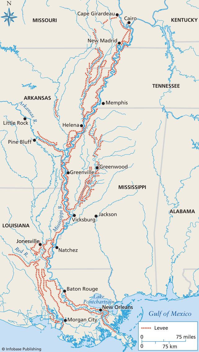
Map of the lower Mississippi River from the mouth of the delta to southern Missouri showing the thousands of miles of levees constructed along the river in the past century
The Ohio River flood of 1937 activated the Birds Point‑New Madrid Floodway via dynamiting of the Fuse Plug Levee, releasing massive water volumes and easing downstream pressure. The flood underscored the need for roads atop levees to facilitate material transport during emergencies. By 1947, the MRC emphasized levee compaction to reduce failure risks. Levees typically fail through three primary mechanisms: underseepage, where water pressure beneath the levee creates a channel leading to catastrophic collapse; hydraulic piping, where water finds a weak passage through the structure; and overtopping, where water flows over the crest and erodes the levee sides. Failure can also occur from scour at the levee base during high flows, promoting slumping and mass collapse. Prolonged floods saturate levee pores, weakening the structure and increasing liquefaction potential, with most failures occurring during extended high‑flow periods that elevate pore pressure and scour risks.
By 1956, the MRC was modeling floods with discharges twice previous estimates, assessing system capacity for 3,000,000 cubic feet (2,300,000 m³) per second. The flood of 1973 set records for the number of days the river remained out of its banks, causing over $183 million in damages and revealing a critical insight: levee construction, wing dikes, and other navigational measures had actually reduced the river’s carrying capacity, resulting in higher flood stages for any given discharge than before the levees were built. The Great Flood of 1993 provided another severe test, resulting in massive system failures. Approximately two‑thirds of all levees in the upper Mississippi River basin were breached, overtopped, or otherwise damaged. The flood claimed dozens of lives, damaged or destroyed 50,000 homes, and caused total damages exceeding $15 billion.
Streams represent a dynamic balance between driving forces and flow resistance. Channel morphology develops in response to quasi‑equilibrium among gradient, discharge, sediment load, bed roughness, and bank resistance. Three main channel types emerge from these interactions: straight channels, which are rare and typically controlled by bedrock incision, though the current within them usually follows a curved path; meandering streams, the most common type, actively erode cut banks while depositing on point bars, allowing meanders to migrate across floodplains and maintain equilibrium through adjustments in sinuosity, wavelength, width‑depth ratio, and velocity; and braided streams, characterized by multiple channels and rapid morphological changes, which transport higher sediment loads and often occur in environments such as glacier forefields where discharge and load fluctuate substantially.
Individual stream channels are components of larger drainage systems, and the patterns of branching and junction angles reflect underlying geological processes. Some systems exhibit dendritic patterns on uniform slopes, while rectangular patterns align with fault or joint systems, radial patterns develop on domal structures such as volcanoes, and certain streams maintain antecedent courses that cut through rising mountain ranges. These regional patterns reflect structural control by bedrock geology, whereas local channel patterns reflect the balance between driving and resisting forces. Streams deposit thick sequences of sand, mud, and gravel on floodplains, later incising through them to form terraces, and transport vast sediment volumes to the sea, where they construct extensive delta complexes. Delta morphology reflects equilibrium among sediment supply, tidal range, and wave energy; individual delta lobes typically remain active for about 1,000 years before the river avulses to a new course and the abandoned lobe subsides.
Date added: 2026-04-26; views: 170;