Historical Geology: Principles, Stratigraphy, and Earth History
Historical geology is the science that applies geological principles to reconstruct and interpret the history of the Earth. This discipline encompasses the study of changes in the Earth’s surface, the record of life, stratigraphy, dating of geological units, plate motion history, past continental positions, mountain belt and basin formation, and ancient climates. The Earth can be compared to a jigsaw puzzle, and historical geology seeks to understand the causes and sequence of events that produced observable features in the geological record, including the origin and fate of living organisms. By examining the rock record, geologists establish a chronology of Earth’s events and have gradually realized that the planet is extremely ancient with a complex history. The rock record demonstrates that life‑forms have evolved from preexisting species through slow, gradual changes over long periods, and this evolution has been punctuated by several major mass extinctions, where large numbers of species and individuals suddenly died off, only to be replaced by entirely new species in younger strata.
Stratigraphic Principles and the Rock Record as Indicators of Earth History. Stratigraphy is the study of rock strata or layers, focusing on their succession, age relationships, lithologic composition, geometry, distribution, correlation, fossil content, and depositional environments. The primary goal of stratigraphy is to interpret the rock record in terms of paleoenvironments, modes of rock origin, and the causes of similarities and differences among stratigraphic units. These units can then be compared across regions, continents, and oceans to reconstruct Earth’s conditions at the time of deposition.
The most basic stratigraphic unit is the formation—a distinctive series of strata that originated through the same formative processes. Formations must be easily recognizable based on lithology, which includes mineral grain composition, color, grain texture, stratification thickness and geometry, fossil character, and outcrop appearance. According to the stratigraphic code, a single layer is a stratum, and many layers within a formation are strata. Groups consist of several related formations, whereas systems comprise several groups.
Early stratigraphers viewed Earth history and the stratigraphic record simplistically, believing that the divisions named in Europe were globally uniform and of the same age, like a layered cake. Gradually, lateral variations between formations became recognized. In 1789, the French polymath Antoine Lavoisier (1743‑1794) suggested that similarities of fossils in similar sedimentary rocks might reflect environmental factors more than age. Lavoisier demonstrated that shallow, near‑shore marine sediments are coarser and contain organisms adapted to rough water, whereas deeper, quiet‑water marine sediments are finer and contain delicate bottom‑dwelling organisms, floaters, and swimmers. He showed that different sedimentary products can form in different environments with different fossil groups, even when deposited at the same time. Five years later, Lavoisier was beheaded during the French Revolution as one of 28 tax collectors branded a traitor.
In the 1830s, British geologists Adam Sedgwick (1785‑1873) and Sir Roderick Impey Murchison (1792‑1871) found that the non‑marine Old Red Sandstone in Britain was laterally equivalent, in part, to marine sandstones. They observed an interfingering relationship, meaning one sediment type or formation grades laterally into another.
Depositional Environments and Facies as a Record of Historical Geologic Conditions. The importance of lateral variations in strata was not fully appreciated until 1838, when interfingering of two different lithologies with distinct fossil assemblages was described from a Swiss mountainside. The term sedimentary facies was introduced to describe the lithological difference between two interfingering rock units, interpreted as products of different depositional environments. The gradual change in rock character reflects a gradual change in original environments, such as a transition from a sandy beach to a muddy offshore shelf. It is customary to name a facies by its dominant lithology (e.g., a mud‑rich rock is called a muddy facies).
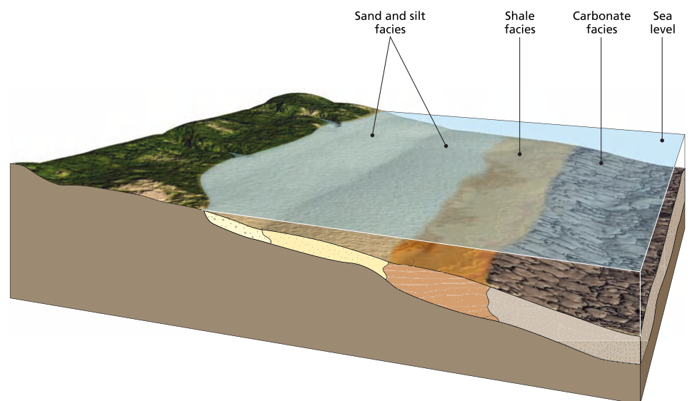
Cross section of beach and near-shore environment showing sedimentary facies change from subaerial dunes to beach to shallow marine to transitional to deep marine. Note how the rocks deposited in each facies interfinger with each other
Analysis of sedimentary facies aims primarily to interpret the depositional environment, thus requiring descriptions of both rock lithologies and contained fossils. A key aspect is the principle of uniformitarianism, where ancient rock features are compared with modern environments to understand their origin. Facies patterns are best understood by examining regional‑scale changes and are essential for reconstructing past environments. By analyzing many facies patterns and determining paleoenvironments, geologists can understand the history of environments and life on Earth—a central goal of historical geology.
Sedimentary facies analysis shows that sea level constantly moves up and down, and that land surfaces also move relative to sea level. Subsidence is the sinking of land relative to sea level, whereas uplift is the rising of land relative to sea level. Currently subsiding areas include Venice (Italy), New Orleans (Louisiana), and the North Sea coast of Holland, which has been sinking for the past 10,000 years since the last glacial advance. Along the Mississippi Delta in southern Louisiana, rapid subsidence causes many square miles of land to sink below sea level each year, moving the shoreline inland toward New Orleans. As subsidence continues, sedimentary environments (shoreline, shallow marine, deeper marine) all move landward, with deeper facies migrating on top of shallow ones. This pattern is called a marine transgression, which can result from land sinking relative to the sea or from a global sea‑level rise.
In contrast, a regression occurs when sea level falls relative to the land, and the shoreline moves away from the present coast. Like a transgression, a regression causes a continuous, gradual shift of sedimentary environments and their products, forming a wedge of material that overlies older deposits from previous facies. In both transgressions and regressions, facies boundaries (and lithology changes) form inclined surfaces, whereas time lines (corresponding to the seafloor surface at any given time) are subhorizontal and cut across lithologies as paleoenvironments changed from beach to nearshore to offshore. Thus, even though formations may be defined as “near‑shore sand” or “offshore mud,” time lines cut across formation boundaries.
To interpret the history of an area, geologists analyze facies patterns to determine whether sea level was rising (transgression) or falling (regression) during deposition. Transgressive patterns are characterized by shrinking land areas, typically underlie an unconformity surface, show a landward shift of facies through time, and become finer upward at any given location. Regressive patterns form from land uplift or sea fall, show enlargement of land area, typically have an erosional unconformity at their top, exhibit a seaward shift of facies with time, and become coarser upward at any given location.
In the late 1800s, German geologist Johannes Walther studied facies patterns extensively and noted that facies tend to shift with time in the geological record, with adjacent environments succeeding each other in vertical sequence. This insight led to Walther’s law, which states that the vertical progression of facies is the same as the corresponding lateral facies changes.
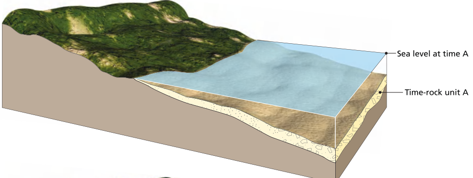
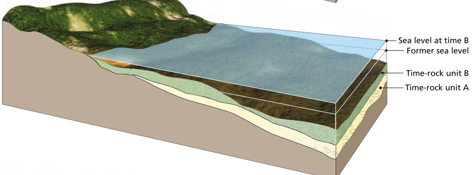
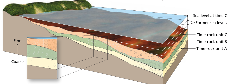
Rising sea level causes the sedimentary facies to migrate shoreward and be deposited one on top of the other and move progressively shoreward. A regression shows the opposite direction of migration of facies. Note how a vertical profile through these sections would yield a sequence of facies that is the same as the horizontal sequence of facies on the surface and that the order of succession can be used to tell the difference between a regressive and a transgressive sequence
Understanding local patterns of marine transgressions and regressions was a major achievement, but correlating these patterns across continents to establish a global pattern proved more difficult. In some cases, one continent rose or fell while others did not; in other cases, geological evidence suggested simultaneous sea‑level changes worldwide. These global sea‑level rise or fall events are called eustatic changes. They may be caused by changes in ocean water volume (from melting or freezing glaciers) or changes in the volume of deep ocean basins (by altering mid‑ocean ridge volume through increased or decreased seafloor spreading). Continental collisions can uplift large portions of continents, effectively decreasing continental material in the oceans, expanding ocean basin volume, and causing global sea levels to fall. To determine whether sea‑level changes are local or global, a well‑correlated geological timescale is needed for each continent, which over time has led to the establishment of global eustatic sea‑level curves showing sea‑level heights through time.
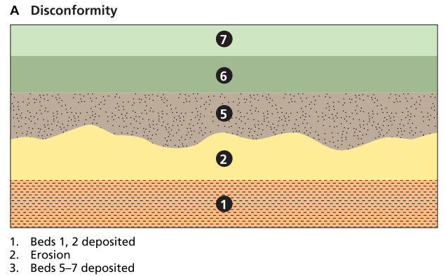
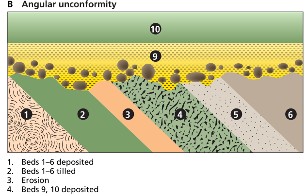
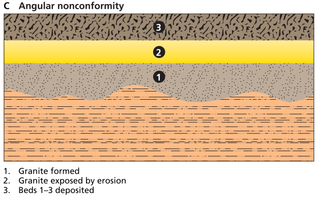
Three types of unconformities, including disconformity, angular unconformity, and nonconformity
Date added: 2026-04-26; views: 261;