The Discipline of Geography. A Geographical Perspective on the Earthquake
Geography is the systematic study of location and place. Geographers ask and answer questions concerning where people, places, and activities are located: why and how they come to be located where they are: and how the unique characteristics of societies and physical environments affect each other at different locations.
The two main branches of geography are physical geography and human geography. Physical geography is that branch of geography that deals with natural phenomena independently of human activity. Human geography deals with the activities of human beings in their natural environment.
A Geographical Perspective on the Earthquake. Within hours after the earthquake struck the San Francisco Bay Area, people around the world had learned about the disaster. Baseball fans saw Candlestick Park shaking on live television. Later, people watched a videotape of the collapse of the Bay Bridge taken on a home video camera by an Oklahoma tourist from her car. Millions more read stories about the earthquake and its effects in newspapers and magazines.
The questions people asked about the earthquake were often tied to their professional interests. Physicians, for example, were concerned about the quality of the emergency medical treatment provided to earthquake victims. Geologists considered new ways in which earthquakes might be predicted. Architects looked to designing buildings that could better withstand earthquake devastation. Economists considered the financial aspects of the disaster and estimated the impacts of cleanup costs on San Francisco's economy, on that of the state of California, and on the economy of the entire United States.
What questions did geographers ask about the San Francisco earthquake? Usually, questions asked by geographers begin with the words where and why. Why do earthquakes occur where they do? Why has California experienced so many devastating earthquakes, whereas many other areas have never experienced any? Research by geographers and geologists has shown that the earth's crust consists of several large plates. These plates move slowly along the surface of the earth. Earthquakes occur at locations where plate boundaries meet. Contact between plates generates faults, and earthquakes take place along these faults.
The North American and Pacific plates meet in California. An extensive system of faults stretches across California and into the Pacific Northwest, British Columbia, and Alaska. Indeed, earthquakes occur frequently along the boundaries of the Pacific Ocean from Chile to Indonesia. Because earthquakes and volcanoes are so common there, the term "Ring of Fire" has been applied to the rim of the Pacific basin.
The countries located along the Ring of Fire include some of the largest and most densely populated cities in the world. San Francisco, Los Angeles, Tokyo, Beijing, Vancouver, Jakarta, and Santiago are among the many major cities located along the Pacific Rim. Since earth-quakes occur so frequently along the Ring of Fire, geographers have often asked how societies cope with the earthquake hazard. In what ways do people in earthquake-prone areas adjust their life-styles to be able to cope with the earthquake threat?
To answer this question, we might compare the San Francisco earthquake with others of similar magnitude elsewhere. On December 7, 1988, an earthquake of similar magnitude struck Armenia, then part of the Soviet Union. More than fifty thousand people were killed. While fourteen thousand Californians lost their homes in the San Francisco earthquake, over half a million were homeless following the Armenian disaster (see Figure 1-1).
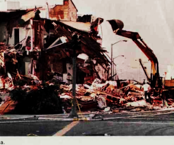
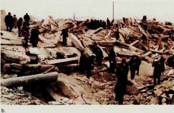
Figure 1-1. Damage from the San Francisco and Armenian Earthquakes. The destructive power of major earthquakes is illustrated by these photographs taken shortly after the San Francisco and Armenian earthquakes in 1989 and 1988, respectively, (a) In San Francisco, few lives were lost, but a considerable time elapsed before life returned to normal, (b) The Armenian earthquake, of similar magnitude as San Francisco's, resulted in catastrophic damage and numerous fatalities and injuries
After the Armenian tragedy, Soviet officials admitted that many damaged buildings in Armenia had been constructed without concern for the substantial earthquake hazard in that part of the world.
In the United States, government officials had been more successful developing and enforcing building codes intended to minimize earthquake damage. Indeed, the most devastating damage occurred in areas where building codes had not been enforced. As we know, over half of the fatalities occurred on or near the collapsed portion of Interstate Highway 880 in Oakland. Transportation safety experts had warned for many years that this portion of the freeway might not be able to withstand a major earthquake. Analysts also found that damage was concentrated on reclaimed land. As shown in Figure 1-2. The Marina district of San Francisco, which is built on reclaimed land, suffered extensive building damage, while buildings only a few blocks away were relatively unharmed.
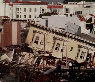
Figure 1-2. Destruction in the Marina District. In the San Francisco region, local differences in the extent of damage resulting from the 1989 earthquake were readily apparent. The well-known Marina district, much of which is built on reclaimed land, suffered extensive damage. Only a few blocks away, there was hardly any damage at all
Geographers might also ask where the effects of the earthquake were felt. Of course, many of the most severe impacts of the earthquake were felt in the immediate vicinity of its epicenter. The fatalities and injuries were concentrated within a short distance of the fault along which the earthquake occurred. Building damage, power loss, and other major disruptions were concentrated over a wider area. Still farther away, local residents experienced only minor effects, such as the rattling of dishes or windows.
In the long run. however, the earthquake affected people throughout California, throughout the United States, and around the world. The cost of cleaning up was borne by the U.S. government and by the state of California, as well as by the numerous companies based in the San Francisco area that do worldwide business. Many business leaders and government officials were fearful that the earthquake would result in a decline in retailing and tourism.
Geographers also frequently ask questions concerning future trends and events. Physical geographers and geologists expect that even stronger earthquakes are likely in San Francisco, Los Angeles, and other populous areas of California in the foreseeable future. Is the earthquake threat sufficient to scare potential migrants away from California? How might continued population growth affect government efforts to warn and protect people from future earthquakes?
Geography as a Way of Thinking. The questions we have just considered are typical of those asked by geographers concerning important current events. But what distinguishes geography from other disciplines? What is unique about the geographer's approach? After all. economists study the workings of the economic system. Anthropologists and sociologists study people within the context of culture. Geologists, as well as physical geographers, study patterns of plate tectonics responsible for such catastrophic events as the San Francisco earthquake.
Nothing that geographers study can be considered unique to geography. Content alone is not sufficient to distinguish geography from other fields of intellectual endeavor. Rather, geography is distinguished from other disciplines by its approach to the collection and organization of knowledge. Geography is a way of thinking rather than the study of specific subject matter.
Date added: 2023-01-05; views: 821;