Rifting. Internal Ridge Structure
Rift zones, or spreading zones, are regions where the lithosphere splits, separates, and is forced apart as new crustal material intrudes into the crack, or rift. The major rift zones are the mid-ocean ridge and rise systems (return to fig. 2.7), hut rifting is not limited to oceanic areas. It occurs on land and, in the past, has been responsible for breaking up landmasses.
The lithosphere-asthenosphere boundary is dependent on temperature. Continental lithosphere is relatively thick (100-150 km, or 60-90 mi); oceanic lithosphere is generally thinner and more variable, increasing in thickness with distance from the ridge and with increasing age of the sea floor. The oceanic lithosphere is almost at the surface along the ridge axis. Its thickness increases to a maximum (100 km, or 60 mi) at an age of about 80 million years and remains constant after that.
For the lithosphere under the continents to crack, some mechanism must thin and apply tension to the lithospheric plate. How this mechanism operates is not fully known. The crust may be under tension because of subduction occurring at the plate margin; the tension stretches and thins the plate to allow magma to rise, weakening the plate so that it cracks under tension and produces a fault zone into which magma eventually flows (fig. 2.22).
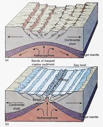
Fig. 2.22. (a) Rifting is thought to happen when magma rises, causing tension and stretching of the overlying plate, (b) As the spreading continues, the fault deepens and cracks, allowing magma to penetrate and eventually form a ridge. Sediments accumulate in the fault, smoothing the sea floor
Another possibility requires a more active role for the mantle processes and appears to be a better explanation of crustal rifting. Rising magma in a mantle convection cell may heat the overlying crust and bow it upward. This bowing weakens the crust and results in localized faulting that allows blocks of crust to drop downward, as seen in the Great Rift Valley of Africa, an actively forming continental rift that stretches from Mozambique to Ethiopia. Such a sunken rift zone is called a graben.
Continuing convection cell motion forces the plates apart, thinning the crust and deepening the fault. Gradually the magma penetrates into the crack and widens the rift. If the rift deepens sufficiently, seawater may enter. The Red Sea today is at this intermediate stage, with both oceanic-type basalt and subsided blocks of continental-type crust present on the floor of the rift.
As the lithospheric plate cools and moves away from the rift, its density increases and magma becomes attached to the lower side of the lithosphere, causing the plate to gradually thicken away from the rift. As the crustal plate continues to thin at the rift, magma wells into the rift at an increasing rate and the landmass is gradually separated into two parts, with a low-lying region of oceanic basalt-type crust between the two sections. A new ocean basin is formed as well as a new ridge system (see fig. 2.22b).
Internal Ridge Structure. Detailed seismic studies, coring, and the direct observation of large transform faults from submersibles have provided ocean scientists with considerable information about the process of rifting, the formation of oceanic crust, and the structure of ridges and rises. A generalized section across a ridge is shown in figure 2.23. This figure shows the four basic layers that make up the oceanic lithosphere.
The topmost layer (layer 1 on fig. 2.23) is composed of sediment; it may not be present at the ridge axis if the sea floor is too young to have acquired a covering of this loose material. Layer 2 is made up of two forms of basalt. The surface portion of this layer is the result of the rapid cooling of magma to form fine-grained, or glassy, lava. The deeper part of the layer is formed from magma that solidifies to form a series of vertically oriented basalt dikes. Layer 3 is also basaltic, but it has cooled more slowly, forming a granular, dark-colored igneous rock called gabbro.
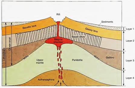
Fig. 2.23. A mid-ocean ridge cross section showing the four layers of the oceanic lithosphere
The Moho is found at the bottom of this layer. Layers 2 and 3 together are usually 6-7 km (=4 mi) thick, but they are thinner at the rift zones. The lithosphere contains these layers and a thick fourth layer of rock known as peridotite that forms the rigid upper mantle and the base of the lithospheric plate. The partly molten asthenosphere portion of the mantle lies below this fourth layer.
The mechanism whereby peridotite produces basalt and gabbro was determined by subjecting laboratory samples of peridotite to the high temperature and pressures found 100 km (60 mi) below the surface of the oceanic crust. When cooled and decompressed, the partially melted peridotite produces rock similar to the basalt found in the upper layers of oceanic crust. In 1989, the French submersible Nautile explored the Verna transform fault on the Mid-Atlantic Ridge. Observers found exposed peridotite overlain by gabbro, next a basalt dike complex 1 km (0.6 mi) thick, topped with glassy basalt.
Date added: 2023-11-08; views: 753;