Listening to Seafloor Spreading
Volcanic events on land are often predicted in advance by seismometers recording the weak, low-frequency Earth tremors associated with moving magma; in active areas, tilt meters are installed to detect the gradual swellings of the Earth's crust prior to eruptions. Volcanism on land is easily recognized as it occurs, and lava and gas samples are taken directly while aircraft and satellites document each event.
Seafloor volcanism is rarely visible, and monitoring equipment has been installed in very few undersea areas. The discovery of a volcanic event in progress has depended on chance; observers must be in the right place at the right time. For example, if researchers are studying the properties of the water, changes in deep-water chemistry or higher water temperature at depth may indicate seafloor volcanism. Surveys of regions thought to be active have been made by manned submersibles or, if the task is too risky, remote operating vehicles (ROVs) might scan these areas.
In August 1991 the U.S. Navy allowed the National Oceanic and Atmospheric Administration (NOAA) access to environmental data collected from its Sound Surveillance Systems (SOSUS). SOSUS are networks of underwater hydrophones (listening devices) installed by the U.S. Navy in the early 1950s. They were set up primarily on continental slopes and seamounts to detect sound signals from submarines and to monitor coastal vessel traffic; however, the system also detects nearby, weak, low- frequency Earth tremors (Richter magnitude 2 or less) and can locate the area where the tremors are formed.
On June 22, 1993, NOAA installed a direct-line system to allow instantaneous acoustic monitoring of the SOSUS network near the Juan de Fuca Ridge, off the Washington and Oregon coasts. On June 26 scientists detected a burst of low-level seismic activity that migrated northward for the next forty hours to a site along the spreading axis of the Juan de Fuca Ridge, where most of the 676 seismic events were measured during the next three weeks.
The intensity, frequency, and duration of the signals indicated that a seafloor spreading episode had occurred, forming a magma dike about 60 km (36 mi) long as well as a possible seafloor extrusion of lava. This area of the Juan de Fuca Ridge is known as the CoAxial segment; it had been surveyed by side-scan bathymetry (see this chapter's box titled "Undersea Robotic Technology") in a two-year survey (1981-82) and again in 1991. These surveys provided the data against which the 1993 changes were measured.
Good fortune in 1993 made available two oceanographic research vessels, the NOAA ship Discoverer and the Canadian research vessel John P. Tully, to respond to these events. Both proceeded to the area of disturbance and began looking for changes in the sea floor and the seawater over the area. The Discoverer detected a recent lava flow covering 3.4 x 10⁵ m2 (0.13 x 10⁵ mi2) and decreasing water depth by about 29 m (95 ft).
The Tully deployed the robotic device ROPOS (Remotely Operated Platform for Ocean Science) that observed an area of fresh glassy lava 2.5 km (1.5 mi) long and 300 m (0.2 mi) wide. ROPOS also observed nearly continuous diffuse venting of warm water (<30°C). Seven to fourteen percent of the new lava flow was covered with orange flocculent material. Samples of this material were collected by ROPOS in July 1 993 and by the submersible Alvin in October of that year. The electron microscope showed the "floe" to contain disorganized aggregations of bacteria and debris.
Water samples taken by ROPOS south of the new lava flow showed elevated levels of manganese, iron, calcium, silica, and lithium but depleted levels of magnesium. Between July 1 and August 2, 1993, towed sensors detected three huge (1.3-4 x 10¹⁰ m3 [0.3-1.0 x 10¹⁰ mi3]) masses of warm water or hydrothermal event plumes called megaplumes.
The production of these vent-water megaplumes is thought to be directly related to the spreading rate and frequency of magma intrusions at a spreading center ridge crest. Before the researchers left the area, they deployed current meters and temperature sensors to continue monitoring the hydrothermal event plumes.
Three months after the eruption, the submersible Alvin descended four times to the area of volcanic eruption, making direct visual observations and measuring the magnetic properties of the new lava flow at the south end of the rift site (box fig. 2.1).
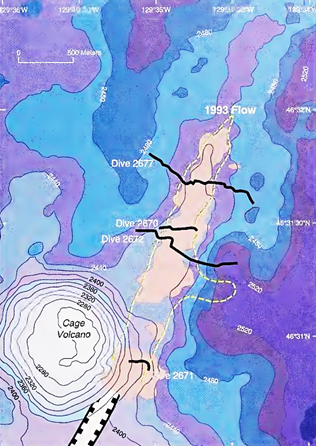
Box figure 2.1. A bathymetric chart of the 1993 Juan de Fuca volcanic event. Fresh lava is shown in pink. The edge of the flow is shown by dashes. Dive tracks of the Alvin are shown in black and identified by dive numbers
The magnetic signal from the new lava was significantly higher than that from older lava; successive surveys indicated a decrease in magnetism at the new lava source. Future studies of this flow will add to our understanding of the rate at which magnetic properties decrease as fresh lava ages and cools. At present, the data point to a 10% decrease in magnetism in the first year after lava formation, due to changes in magnetic material exposed to seawater.
There are still unanswered questions in the interpretation of this event. The origin of the burst of seismic activity at the north end of the rift zone is still unclear. The presence of megaplumes appears to point to a preexisting hydrothermal system for which there is no crustal evidence at this time. Analysis of the 1 993 data and monitoring of the SOSUS net continue as oceanographers listen for more signals of volcanic events. Detecting mid-ocean ridge events as they occur enables scientists to be in the right place at the right time to observe and investigate the dynamics of seafloor spreading.
Date added: 2023-11-08; views: 755;