Hot Spots. Polar Wandering Curves
Scattered around the Earth are approximately forty fixed,, areas of isolated volcanic activity known as hot spots. They are found under continents and oceans, in the center of plates, and at the mid-ocean ridges. These hot spots periodically channel hot material to the surface from deep within the mantle. At these sites, a plume of mantle material may force its way through the lithosphere and form a volcanic peak, or seamount, directly above.
If the hot spot does not break through, it may produce a broad swelling of the ocean floor or the continent that will subside as the plate moves over and away from the magma source. Hot spots may also resupply the asthenosphere, which is constantly cooling and becoming attached to the .base of the lithosphere, thickening the plates. Some people believe that the breakup of Pangaea began when a chain of hot spots developed under the supercontinent.
Hot-spot plumes of magma are not uniform; they differ in chemistry, suggesting that they come from different mantle depths, and it has been suggested that their discharge rates may also vary. Hot spots may fade away and new ones may form. The life span of a typical hot spot appears to be about 100 million years. Although their positions may change slightly, they tend to remain relatively stationary in comparison to moving, plates and they can be useful in tracking plate motions.
As the oceanic crust moves over a hot spot, successive eruptions can produce a linear series of peaks, or seamounts. In such a series, the youngest peak is above the hot plume, and the seamounts increase in age as their distance from the hot spot increases (fig. 2.26). For example, in the islands and seamounts of the Hawaiian Islands system, the island of Hawaii, with its active volcanoes, is presently located over the hot spot. The newest volcanic seamount in the series is Loihi, found in 1981 45 km (28 mi) east of Hawaii’s southernmost tip and rising 2450 m (8000 ft) above the sea floor but still under water.
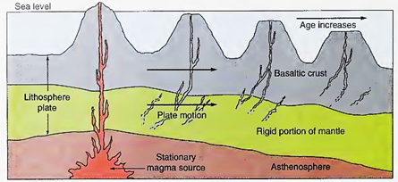
Fig. 2.26. A chain of islands is produced when a crustal plate moves over a stationary hot spot
The land features of the island of Hawaii show little erosion, for it is comparatively young. To the west are the islands of Maui, Oahu, and Kauai, which have been displaced by the moving crust. Kauai’s canyons and cliffs are the result of erosion over the longer period of time that it has been exposed to the winds and rains. Although these four islands are the most familiar, other islands and atolls attributed to the same hot spot stretch farther west across the Pacific.
They are peaks of eroded and subsided seamounts formed by the same hot spot. Subsidence occurs when the heated and expanded plate moves slightly downhill and away from the mantle bulge over the hot spot. As the plate moves away from the hot spot it cools and contracts, and when combined with the weight of the seamount it is carrying, the result is a depression in the mantle that gradually carries the seamount below the ocean surface. When seamounts in tropical areas sank slowly, coral grew upward and coral atolls were the result.
West of Midway Island, the chain of peaks changes direction and stretches to the north, indicating that the Pacific Plate moved in a different direction some 40 million years ago. This line of peaks is the Emperor Seamount Chain, 'volcanic peaks that once were above the sea surface as islands but have since eroded and subsided over time, resulting ш many flat-topped seamounts known as guyots 1000 m (0.6 mi) below the surface.
The northern end of the Emperor Seamount Chain is estimated to be 75 million years old, and Midway Island itself may be 25 million years old. Refer to figure 2.7 to follow this seamount chain. Notice in figure 2.26 that the peaks formed by the hot spot get older in the direction in which the plate is moving. The plate is presently moving westward; Midway Island is northwest of the main Hawaiian Islands, and it is also older.
It is possible to check the rate at which the plate is moving by using the distance between seamounts in conjunction with radiometric dating. For example, the distance between the islands of Midway and Hawaii is 2700 km (1700 mi). Midway was an active volcano 25 million years ago, when it was located above the hot spot currently occupied by Hawaii. In other words, Midway has moved 2700 km (1700 mi) in 25 million years, or 11 cm (4 in) per year.
There is another hot spot at 37° 27'S, in the center of the South Atlantic, which is marked by the active volcanic island of Tristan da Cunha. Volcanic activity at this more slowly diverging plate boundary produces seamounts that can be carried either to the east or to the west, depending on the side of the spreading center on which the seamount was formed. The hot spot produces a continuous series of seamounts very close together, forming a transverse ridge: the Walvis Ridge to the east, between the Mid-Atlantic Ridge and Africa, and the Rio Grande Rise to the west, between the Mid-Atlantic Ridge and South America. Refer to figures 2.7 and 3.14.
If a hot spot is located at a spreading center, the flow of material to the surface is intensified. The crust may thicken and form a platform. Iceland is an extreme example of this process in which the crust has become so thick that it stands above sea level.
Seamount chains, plateaus, and swellings of the sea floor, all products of hot spots, are being used to trace the motion of the Earth’s plates over known hot-spot locations. Recently, hot-spot tracks have been used to reconstruct the opening of the Atlantic and Indian oceans. Although the exact mechanism is not known, hot spots also appear to have formed huge basaltic plateaus: the Kerguelen Plateau in the southern Indian Ocean about 110 million years ago, and the Ontong Java Plateau in the western Pacific about 122 million years ago.
Polar Wandering Curves. Magnetic rocks of different ages that are found on the same plate point to different magnetic pole positions. Records of the angular relationship between the magnetic pole and the geographic pole were locked in these rocks at the time of their formation. If these locations of magnetic north are plotted, and if it is assumed that the plate has remained in a fixed position through time, it appears that the Earth’s magnetic poles have wandered away from their present positions relative to the Earth’s north-south axis. A path plotted in this way for any continent or plate section is known as a polar wandering curve (fig. 2.27).
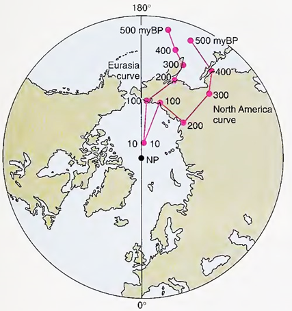
Fig. 2.27. The positions of the north magnetic pole millions of years before present (myBP), judged by the magnetic orientation and the age of the rocks of North America and Eurasia. The divergence of the two paths indicates that the landmasses of North America and Eurasia have been displaced from each other as the Atlantic Ocean opened
Because rocks of the same age from two different plates': point to two different locations for the magnetic pole, and because all evidence points to the magnetic poles’ remaining close to the geographic poles, even though the magnetic polarity has reversed through time, it is thought that и is the plates that have moved and not the poles. If the magnetic poles remain close to the geographic poles and the plates move and rotate, then polar wandering curves can be used to track the movements of the plates with time.
When the polar wandering curves formed from the changes in the magnetic orientation of the North American and northern European plates are superimposed, the movements of these plates reconstruct the formation of the two-lobed portion of Pangaea proposed by Wegener, with Laurasia to the north, Gondwanaland to the south, and the Sea of Tethys in between. On the basis of this method, the present landmasses join nicely at the edges of the continental blocks, at a boundary on the continental slope that is about 2000 m (6560 ft) below the present sea level.
When the plates and their landmasses are moved together, major ancient mountain and fault systems spanning several of our modern continents join; for example, the fault through the Caledonian Mountains of Scotland joins the Cabot Fault extending from Newfoundland to Boston. Also, countries of western Europe and Great Britain that are at present located in temperate and high latitudes were once found in the equatorial zone; their movement explains their fossil coral reefs and desert-type sand deposits.
Current research leads some scientists to believe that the assumption that the rotational polar axis has not varied its location over time may not be correct. The rotating Earth possesses tremendous inertia, which keeps it spinning on its axis. However, as the lithospheric plates migrate about on the Earth’s surface, the Earth may tend to roll about its center slightly, trying to adjust so that the majority of the Earth’s crustal mass is centered about the equator. If the Earth does roll about its center, the location of the pole points marking the Earth’s rotational axis relative to the crust may also shift.
Date added: 2023-11-08; views: 847;