The Ridges, Rises, and Trenches
The most notable features of the ocean floor are the mid' ocean ridge and rise systems stretching for 65,000 km (40,000 mi) around the world and running through every ocean. Their origin and their role in plate tectonics were discussed in chapter 2. Refer to figure 2.7 and review their distribution using figure 3.14. Recall also the roles played by their rift valleys and transform faults.
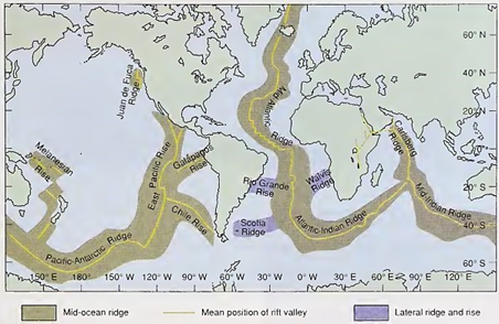
Fig. 3.14. The mid-ocean ridge and rise system with its central rift valley is continuous and appears in all oceans
The relationship of the deep-sea trenches to plate tectonics was also discussed in chapter 2. (See fig. 2.7 and use fig. 3.15 to trace the Japan-Kuril Trench, the Aleutian Trench, the Philippine Trench, and the deepest of all ocean trenches, the Mariana Trench.) All these trenches are associated with island arc systems. The Challenger Deep, a portion of the Mariana Trench, has a depth of 11,020 m (36,000 ft), making it the deepest known spot in all the oceans.
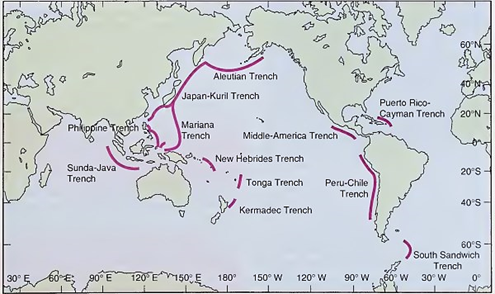
Fig. 3.15. Major ocean trenches of the world. The deepest ocean depth is 11,020 m, east of the Philippines in the Mariana Trench. It is known as the Challenger Deep
The longest of the trenches is the Peru-Chile Trench, stretching 5900 km (3700 mi) down the western side of South America. To the north, the Middle America Trench borders Central America. The Peru-Chile and Middle America trenches are not associated with volcanic islands but are bordered by land volcanoes.
In the Indian Ocean the great Sunda-Java Trench runs for 4500 km (2800 mi) along Indonesia. In the Atlantic there are only two comparatively short trenches: the Puerto Rico-Cayman Trench and the South Sandwich Trench, both associated with chains of volcanic islands. To view the bathymetry of the ocean floor as it is known to exist today, see figure 2.7.
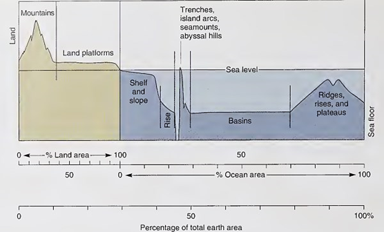
Fig. 3.16. The Earth’s main topographic features shown as percentages of the total Earth’s surface and as percentages of the land and of the oceans
Figure 3.16 summarizes the topography of the land and the bathymetry of the sea floor as percentages of the Earth’s area. Compare the tectonically active areas of trenches and ridges. Compare the area of low-lying land platforms with the area of the ocean basins.
Early mariners and scholars believed that the oceans were large basins or depressions in the Earth's crust, but they did not conceive that these basins held features that were as magnificent as the mountain chains, deep valleys, and great canyons of the land. As maps became more detailed and as ocean travel and commerce increased, measurement of water depths and recording of seafloor features in shallower regions became necessary to maintain safe travel and ocean commerce.
The secrets of the deeper oceanic areas had to wait for hundreds of years until the technology of the late twentieth century made it relatively easy to map and sample the sea floor. It was only then that large numbers of survey vessels accumulated sufficient data to provide the details of this hidden terrain.
What we know about the sea floor and its covering of sediments comes almost entirely from the observations by surface ships, and, more recently, submersibles, robotic devices, and satellites have added to our knowledge. Some areas of the sea floor have been measured in great detail; charts of other areas have been made from scanty data. The demand for more measurements to describe and explain the features of the sea floor continues to the present.
This chapter surveys the world's ocean floors and discusses their topography and geology. It examines the sources, types, and sampling of sediments and also discusses seabed mineral resources.
Date added: 2023-11-08; views: 825;