The Bathymetry of the Sea Floor. The Continental Margin
The land below the sea surface is as rugged as any land above it. The Grand Canyon, the Rocky Mountains, the desert mesas in the Southwest, and the Great Plains all have their undersea counterparts. In fact, the undersea mountain ranges are longer, the valley floors are wider and flatter, and the canyons are often deeper than those found on land. Features of land topography, such as mountains and canyons, are continually and aggressively eroded by wind, water, and ice as well as changes in temperature and the chemical alteration of minerals in rocks. The erosion of ocean bathymetry is generally slow.
Physical weathering is accomplished primarily by waves and currents, and chemical erosion occurs by the dissolution of minerals in the water. More rapid erosion is generally restricted to the continental margin as discussed in section 3.3. The most important agents of physical change on the deep sea floor are the gradual burial of features by a constant rain of sediments falling from above and volcanism associated with the mid-ocean ridge system, hotspots, island arcs and active seamounts, and abyssal hills.
Movements of the Earth’s crust may displace features and fracture the sea floor, and the weight of some underwater volcanoes may cause them to subside, but the appearance of the bathymetric features of the ocean basins and sea floor has remained much the same through the last 100 million years. Computer-drawn profiles of crustal elevations across the United States and the Atlantic Ocean are shown in figure 3.4.
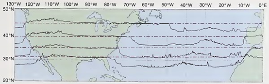
Fig. 3.4. Computer-drawn topographic profiles from the western coast of Europe and Africa to the Pacific Ocean. The elevations and depths above and below 0 meters are shown along a line of latitude by using the latitude line as zero elevation, For example, the ocean depth at 40°N and 60°W is 5040 m (16,531 ft). The vertical scale has been extended about 100 times the horizontal scale. If both the horizontal and vertical scales were kept the same, a vertical elevation change of 5000 m would measure only 0.05 mm (0.002 in)
At 40°N latitude the height above zero elevation (dotted line) and width of mountains in the western United States is about the same as the height and width of the Mid-Atlantic Ridge system on the sea floor. Compare the topography of the Rocky Mountains and the undersea peaks in this figure.
The Continental Margin. The edges of the landmasses at present below the ocean surface and the steep slopes of these landmasses that descend to the sea floor are known as the continental margin. There are two basic types of continental margins. These are often called passive, or Atlantic, margins and active, or Pacific, margins. Passive margins have little seismic or volcanic activity and involve a transition from continental crust to oceanic crust in the same lithospheric plate.
They form when continents are rifted apart, creating a new ocean basin between them. Passive margins tend to be relatively wide. Active margins are tectonically active and associated with earthquakes and volcanism. They are most often associated with plate convergence and the subduction of oceanic lithosphere beneath a continent. Active margins are plate boundaries and are frequently relatively narrow.
The continental margin is made up of the continental shelf, shelf break, slope, and rise. The continental shelf lies at the edge of the continent; continental shelves are the nearly flat borders of varying widths that slope very gently toward the ocean basins. Shelf widths average about 65 km (40 mi) but are typically much narrower along active margins than passive margins. The width of the continental shelf can be as much as 1500 km (930 mi). Water depth at the outer edge of the continental shelf varies from 20 to 500 m (65-1640 ft), with an average of about 130 m (427 ft).
The distribution of the world’s continental shelves is shown in figure 3.5. The width of the shelf is often related to the slope of the adjacent land; it is wide along low-lying land and narrow along mountainous coasts. Note the narrow shelf along the western coast of South America and the great wide expanses of continental shelf along the eastern and northern coasts of North America, Siberia, and Scandinavia.
The continental shelves are geologically part of the continents, and there are several processes that contribute to their formation. Storm waves may erode continental shelves (fig. 3.6i) and, in some areas, natural dams trap sediments between the offshore dam and the coast (fig. 3.6ii, iii). Seamounts and island arcs (fig. 3.6iv) and coral reefs (fig. 3.6vi) also trap sediments. In the Gulf of Mexico sediments from the land are trapped behind folds and domes of the sea floor containing salt deposits (fig. 3.6v). Along the northeastern coast of North America sediments are trapped behind upturned rock near the outer edges of the continental shelf (fig. З.біі).
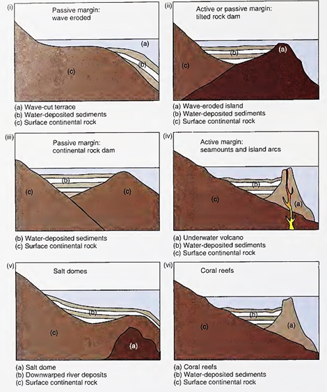
Fig. 3.6. Examples of how continental shelves are formed by trapping land-derived sediments at the edge of the continental landmasses
During past ages, the shelves have been covered and uncovered by fluctuations in sea level. During the glacial ages of the Pleistocene Epoch there were a number of short-term changes in sea level, some of which were greater than 120 m (400 ft). When the sea level was low, erosion deepened valleys, waves eroded previously submerged land, and rivers left sediments far out on the shelf. When the glacial ice melted, these areas were flooded and sediments built up in areas closer to the new shore. At present, although submerged, these areas still show the scars of old riverbeds and glaciers they acquired when part of the landmass.
Today, some continental shelves are covered with thick deposits of silt, sand, and mud sediments derived from the land: for example, the mouths of the Mississippi and Amazon rivers, where large amounts of such sediments are deposited annually. Other shelves are bare of sediments, such as where the fast-moving Florida Current sweeps the tip of Florida, carrying the sediments northward to the deeper water of the Atlantic Ocean.
The boundary of the continental shelf on the ocean side is determined by an abrupt change in slope and a rapid increase in depth. This change in slope is referred to as the continental shelf break; the steep slope extending to the ocean basin floor is known as the continental slope. These features are shown in figure 3.7.
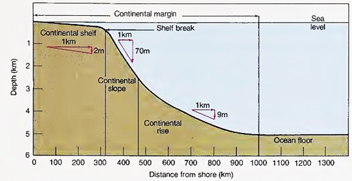
Fig.3.7. A typical profile of the continental margin. Notice both the vertical and horizontal extent of each subdivision. The slope is indicated for the continental shelf, slope, and rise. The vertical exaggeration is 100 times greater than the horizontal scale
The angle and extent of the slope vary from place to place. The slope may be short and steep (for example, the depth may increase rapidly from 200 m [650 ft] to 3000 m [10,000 ft], as in fig. 3.7), or, along an active margin, it may drop as far as 8000 m (26,000 ft) into a great deep-seafloor depression or trench (for example, off the western coast of South America, where the narrow continental shelf is bordered by the Peru-Chile Trench). The continental slope may show rocky outcroppings and be relatively bare of sediments because of its steepness, tectonic activity, or a low supply of sediments from land.
The most outstanding features found on the continental slopes are submarine canyons. These canyons sometimes extend up, into, and across the continental shelf. A submarine canyon is steep-sided and has a V-shaped cross section, with tributaries similar to those of river-cut canyons on land. Figure 3.8a shows the Monterey and Carmel canyons off the coast of California.

Fig. 3.8. (a) Depth contours depict the Monterey and Carmel canyons off the California coast as they cut across the continental slope and up into the continental shelf, (b) Cross-canyon profile of the Monterey Canyon shown in (a). Compare this profile with that of the Grand Canyon drawn to the same scale
Figure 3.8a is a bathymetric chart; figure 3.8b compares the profile of the Monterey Canyon with the profile of the Grand Canyon of the Colorado River. A submarine canyon is also shown in figures 1.11 and 1.12.
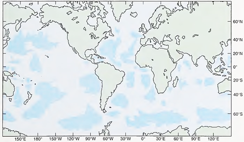
Fig. 3.11. The major ocean basins of the world (dark blue) are separated by ridges, rises, and continents
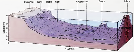
Fig. 3.12. An idealized portion of ocean basin floor with abyssal hills, a guyot, and a seamount on the abyssal plain. Seamounts and guyots are known to be volcanic in origin. Vertical x 100
Many of these submarine canyons are associated with existing river systems on land and were apparently cut into the shelf during periods of low sea level, when the glaciers advanced and the rivers flowed across the continental shelves. Ripple marks on the floor of the submerged canyons, and sediments fanning out at the ends of the canyons, suggest that they were formed by moving flows of sediment and water called turbidity currents.
These sediment-laden currents can travel at speeds up to 90 km (56 mi) per hour and carry in suspension up to 300 kg of sediment per cubic meter (18.7 lb per cubic foot). Caused by earthquakes or the overloading of sediments on steep slopes, turbidity currents are fast-moving avalanches of mud, sand, and water that flow down the slope, eroding and picking up sediment as they gain speed. In this way the currents erode the slope and excavate the submarine canyon. As the flow reaches the bottom it slows and spreads, and the sediments settle. Because of their speed and turbulence, such currents can transport large quantities of materials of mixed sizes.
The settling process produces graded deposits of coarse materials overlain by successive layers of decreasing particle size. These graded deposits are called turbidites. Figure 3.9 shows a turbidite preserved in compacted seafloor sediments that have been uplifted and exposed by wave erosion. These large and occasional currents have never been directly observed, although similar but smaller and more continuous flows, such as sand falls, have been observed and photographed (fig. 3.10).
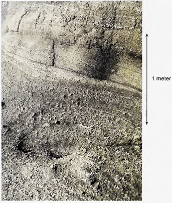
Fig. 3.9. This beach cliff shows a series of ancient turbidite flows that were uplifted and then exposed by wave erosion
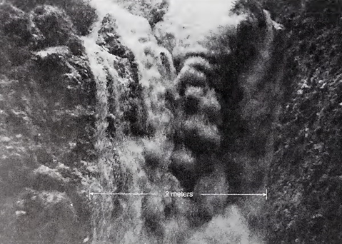
Fig. 3.10. Sand fall in San Lucas submarine canyon. Sand moving down the continental slope is deflected seaward to the ocean basin floor
Research on turbidity currents began with laboratory experiments in the 1930s. These experiments were based on earlier observations of the silty Rhone River water moving along the bottom of Lake Geneva in Switzerland. Later analysis of a 1929 earthquake that broke transatlantic telephone and telegraph cables on the continental slope and rise off the Grand Banks of Newfoundland showed a pat tern of rapid and successive cable breaks high on the continental slope, followed by a sequence of downslope breaks after the earthquake.
These breaks were calculated to have been caused by a turbidity current that ran for 800 km (500 mi) at speeds of 40-55 km (25-35 mi) per hour. Later samples taken from the area showed a series of graded sediments at the end of the current’s path. Searches of cable company records showed similar patterns of cable breaks in other parts of the world.
A turbidity flow can be demonstrated by placing water and loose sediments of mixed particle size in a six-foot section of 2-3 inch diameter clear plastic tube. Cap both ends securely and stand the tube on end for a day or so. Then carefully tilt the tube until it is horizontal and slowly elevate the end with the sediments. Tap the tube gently as you raise it, and the sediments will move down slope as a turbidity flow. When the sediment settles at the other end, a turbidite pattern is formed.
Canyons with U-shaped cross sections and flat bottoms have been found off rivers that supply large quantities of sediments, such as the Ganges River. Continental shelves also show numerous gullies, probably formed by loose sediments moving down the slope.
At the base of the steep continental slope there may be a gentle slope formed by the accumulation of sediment. This portion of the sea floor is the continental rise, made up of sediment deposited by turbidity currents, underwater landslides, and any other processes that carry sands, muds, and silt down the continental slope. Continental rises may be compared to the landforms known as alluvial fans found where outwashes from steep gullies spread across a valley floor.
The continental rise is a conspicuous feature at passive margins in the Atlantic and Indian oceans and around the Antarctic continent. Few continental rises occur in the Pacific Ocean, where active margins border the great seafloor trenches located at the base of the continental slope. Refer to figure 3.7 to see the relationship of the continental rise to the continental slope.
Date added: 2023-11-08; views: 835;