Winds on an Ideal Earth. The Rotating Earth
We assume for this discussion that the earth is motionless and is covered with water Surrounding this earth is the atmosphere, whose lower portions are in contact with the sea and are therefore saturated with water vapor. The water and the atmosphere are heated by solar radiation. This heat becomes more intense near the equator. The air in the vicinity of the equator is heated relative to the surrounding air; its density will decrease, and it will rise.
This motion will cause surface air from higher latitudes to flow toward the space left by the rising equatorial air. Actually, the rising air represents a region of relatively low atmospheric pressure. Air, like any fluid, flows toward a zone of low pressure. The equatorial air rises to an altitude determined by its density (i.e., it seeks its own level) and begins to spread laterally toward the poles.
A commonly observed analogy to this phenomenon is smoke discharged into still air. The smoke ascends from the stack to a level determined by the density of the smoke and the density gradient in the lower atmosphere. At that level it begins to spread laterally (Fig. 7-4).
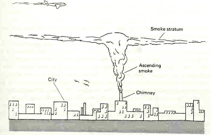
Figure 7-4. The smoke rising to a level where its density is less than that of the air below and greater than that of the air above
As equatorial air rises into a region of lower atmospheric pressure it expands, its temperature decreases, and it becomes saturated with water vapor to the extent that condensation occurs.
This imaginary system is shown in Fig. 7-5. The equatorial surface regions of the globe are characterized by warm temperatures, relatively low atmospheric pressure, clouds, and rainfall. In the polar regions, the temperatures are low, surface atmospheric pressure is high, and water vapor content is low, which causes precipitation to be low.
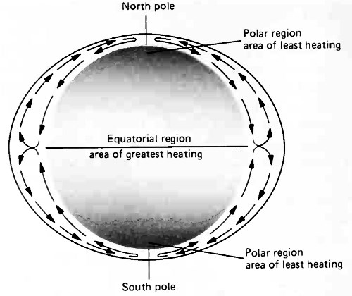
Figure 7-5. Ideal atmospheric circulation for a uniform, nonrotating, nonrevolving earth. (After U.S. Navy Hydrographic Office, Publication No. 9, 1958)
The Rotating Earth. We must next consider the effect of the earth's rotation on the pattern of wind at the surface of the ocean.
The fact that the earth is rotating and that we are rotating with it has a startling influence on the way in which we visualize the motion of an object. One example is the movement of the stars as observed from earth. Just because the stars trace a circular path across the sky does not mean that they are actually moving in a circular path.
We only see their motion relative to us. If we could free ourselves from the rotation of the earth, the stars would not appear to move m this manner. For example, the stars do not change positions relative to each other as they circle the sky (constellations have maintained their identities throughout history). It is important to emphasize that the direction of motion as observed by an individual is a relative thing, depending not only on the motion of the object but on the vantage point of the observer.
Newton's second law of motion
F = Mα [7-1]
states, in part, that a force, F, acting on an object having a mass, M, causes that body to accelerate at a rate, a, in the direction of the impressed force. If a force is applied to an object at rest it will be accelerated and the motion will be in a straight line when viewed from a place fixed with respect to the stars.
If an object is in a state of constant motion (not accelerating) and a force is applied from the side, then the object will be accelerated in the direction of the applied force and hence will change its direction—that is, be turned from its previous direction. Thus, any object whose path of movement is curved, or increasing or decreasing in velocity (when viewed from a place fixed with respect to the stars) is being acted on by a force.
In viewing the motion of an object we encounter a problem because we are forced to use a reference position that is on the earth and that rotates with the earth. As a result, observations are difficult because an object moving in a straight line (with respect to the stars) past the earth would appear to an observer on earth to follow a curved path. You can verify this by imagining yourself to be riding a carousel, while a person at the center is playing catch with another person standing on the ground at some distance away from the carousel.
If the ball is thrown toward the center of the carousel at the instant everyone is aligned in a straight line, it would appear that you would be able to intercept the ball. However, in the time it takes the ball to reach your position, you have moved in such a way that the ball appears to pass your side. From your rotating vantage point, you would testify that the ball was following a curved path, whereas the person standing on the ground to catch the ball would testify as to its rectilinear motion.
Furthermore, you would conclude that a force had to be acting on the ball to account for its continual change in direction with respect to your position. Note that if the carousel has a counterclockwise rotation, the apparent curvature is to the left. A clockwise rotation causes an apparent curvature to the right.
Our vantage point on the earth is a rotating one. Thus, if we want to describe the motion of an object on the earth by using Newton's second law, his equation of motion must be adjusted to describe the apparent curvature of the object's path. We make the adjustment by stating that a force is acting on the object, because a moving object deviates from rectilinear motion only when a force is applied to it. So, to the equation of motion, we add an apparent, or fictitious "force" that acts at an angle 90° from the direction of motion and accounts for the observed deviation.
This fictitious force is called the Coriolis effect, and it adapts Newton's second law to observations of motion made on the rotating earth. Mathematically, the Coriolis effect is stated as follows:

where Fc = force per unit mass due to the Coriolis effect, w — angular rotation of the earth (a constant) in degrees per unit times, ф = degrees latitude, and v = velocity of the moving body.
Four additional statements can be made about the Coriolis effect:
1. It is an apparent force. It cannot do work or initiate motion (when v = 0, F0 = 0). It can only account for the altered motion that we observe because of our rotating vantage point.
2. A moving object deviates to its right in the northern hemisphere and to its left in the southern hemisphere.
3. For a given velocity, the magnitude of this force increases with latitude, being zero at the equator (sin 0° = 0) and maximum at the poles (sin 90° = 1).
4. At any given latitude (except the equator), the greater the velocity, the greater the force.
Note that this effect is only important to the equation of motion when the motion involved is of a global scale. In most scientific work and laboratory experiments, Coriolis effects (apparent curvature of motion) are insignificant. Marine and atmospheric scientists deal with movements on a worldwide scale so they must include the curvature of motion in their equations.
Applying this concept to our rotating earth, we find that as the equatorial air rises and begins to move toward the poles, it would appear to follow a path that is curved to the right in the northern hemisphere and to the left in the southern hemisphere. As a result, there is a system of high-altitude westerly winds at the midlatitudes (Fig. 7-6).
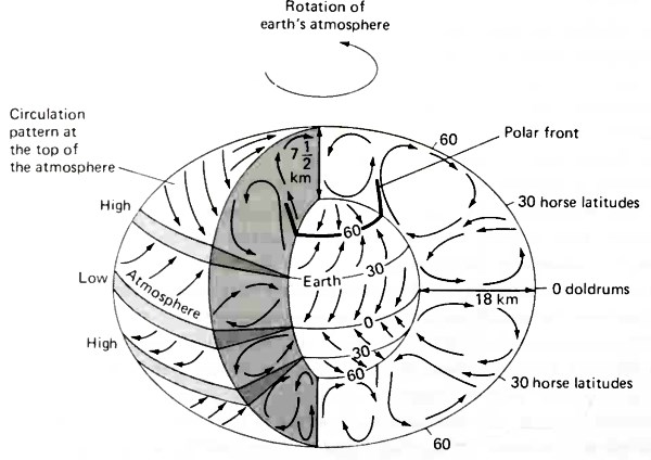
Figure 7-6. Simplified diagram of the general circulation of the atmosphere. Air rising from the equator spreads toward the poles, is deflected eastward, and accumulates at 30° latitude to form the subtropical high-pressure belts. Note the eastward flow of air everywhere at high elevations. This gives rise to the jet stream. (After Strahler, 1963, and U.S. Hydrographic Office, Publication No. 9, 1958)
Since the northward (or southern) component of flow has been decreased, air tends to accumulate, causing high- pressure regions to occur between 20° and 30° latitude. These subtropical high- pressure belts modify the circulation within the lower atmosphere in such a way that air sinks at about 30° latitude and flows toward both the equator and the poles. The air that sinks spreads laterally. That air that moves toward the equator is warmed subsequently and rises, thus completing a tropical circulation system (Fig. 7-6).
The surface air moving in a poleward direction from 30° latitude tends to flow over the more dense polar air existing north of 50° to 60° latitude. The confluence between these two air masses is called the polar front. It represents a region of highly changeable weather conditions caused by the interaction of relatively warm and moist subtropical air with cold, dry air from the higher latitudes. The net result is the formation of another cell of moving air that rises at about 60° latitude and sinks at the poles.
Figure 7-7 illustrates the winds that result from differential solar heating on a water-covered, rotating earth. A more realistic picture is obtained by including three circulation cells in each hemisphere (called Hadley cells). Rotational effects are represented by the deflection of surface winds to the right in the northern hemisphere and to the left in the southern hemisphere.
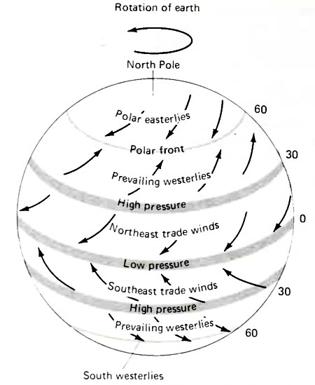
Figure 7-7. Wind and pressure patterns on a rotating earth
This pattern of surface winds forms six zones or belts that travel obliquely toward the poles or toward the equator rather than due north or south. These belts of winds encircle the earth latitudinally and are named the trade winds, the prevailing westerlies, and the polar easterlies.
It is worth noting the climatic conditions that result from the observed air circulation. In the regions of rising air, the climate is characterized by:
1. Low atmospheric pressure (rising low-density air)
2. Much rainfall and cloudiness
3. Light and variable winds (doldrums).
In the zones of sinking air, there is:
1. High atmospheric pressure (sinking dense air)
2. Cool and dry air, leading to excessive evaporation and low rainfall
3. Light and variable winds (horse latitudes).
The regions of convergence or divergence of surface winds and the common names given to these areas are also shown in Fig. 7-6. Generally, the doldrums are characterized by calms or light winds; the horse latitudes, by light and variable winds; and the polar front region, by strong winds. In fact, sailors used to call winds in these polar areas the "roaring forties" and "furious fifties.".
Date added: 2024-04-08; views: 711;