GPS Space Segment Evolution
Institution of the GPS Program led to the launch of two technology demonstration satellites, with the first atomic clocks ever launched into space. The first Navigation Technology Satellite, denoted NTS-1, was a modified TIMATION satellite. It was launched in 1974, and used two rubidium-vapor frequency standards (clocks) to generate signals composed of a set of sequential side tones centered at 335 MHz and 1580 MHz. NTS-1 was fitted with laser retroreflectors for precise orbit determination. The NTS-1 orbital altitude, slightly less than 14,000 km, was significantly lower than the eventual GPS orbital altitude, leading to an orbital period of slightly less than 8 hours.
The NTS-2 satellite, launched in 1977 and portrayed in Figure 3.2, introduced many technologies fundamental to satnav [28]. Also known as the first GPS Phase 1 satellite, it used cesium frequency standards for signal generation and a nickel-hydrogen battery to provide power during solar eclipses. Its three-axis gravity-gradient stabilization employed momentum-wheel unloading. Like NTS-1, it was fitted with laser retroreflectors for precise orbit determination. Besides side tone ranging, it could also transmit a direct sequence spread spectrum signal. Experiments performed using its signals verified Einstein’s relativistic clock shift. Figure 3.2 shows NTS-1 and NTS-2, with their long structures to perform gravity stabilization.
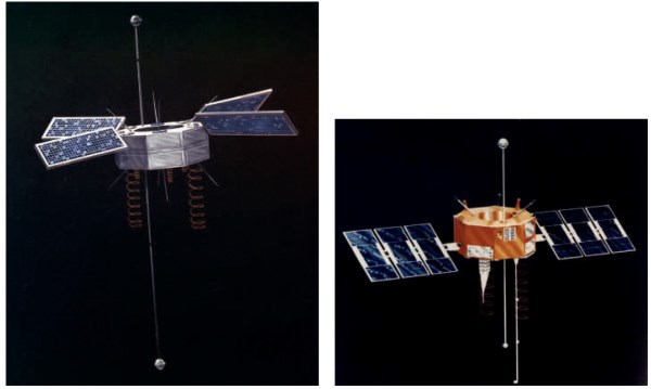
Figure 3.2. NTS-1 [29] (Left) and NTS-2 satellites. Images Courtesy of US Naval Research Laboratory. Source: (Left) Reproduced with permission of Gunter Dirk Krebs. (Right) Reproduced with permission of Gunter Dirk Krebs
While numerous constellation architectures were considered, the selected GPS constellation placed satellites in six planes evenly spaced around Earth, inclined at 55°. The orbits are circular, with a medium Earth orbit (MEO) altitude of approximately 20,200 km. This orbit design resulted in two orbits per sidereal day, and hence each satellite had a repeating ground track every day. The specified minimum number of satellites is 24, and 30 or 31 satellites have been operational more recently.
A complete listing of GPS satellite launches is found at [31]. Ten more Block I satellites were launched from 1978 through 1985, one of which was lost to launch failure [32]. These satellites were used to validate the fundamental concepts of GPS, leading to the decision to deploy a full operational system. Block I satellites were three-axis stabilized and nadir pointing using reaction wheels. Dual solar arrays supplied over 400 W at end of life, and nickelcadmium batteries supplied power during eclipses. TT&C used S-band Space-Ground Link Subsystem (SGLS) communications, and UHF cross-links were implemented between spacecraft. Like subsequent GPS satellites, a hydrazine propulsion system was used for station-keeping. Block I satellites transmitted the C/A-signals and P-signals.
In 1989, the launch of the first operational GPS satellites, termed Block II, began. These launches had been delayed, since the initial plan was to deploy the GPS satellites using the space shuttle, but the 1986 Challenger disaster caused a change of plans, leading to the use of Delta II rockets. Nine Block II satellites were launched in 20 months. Block IIA (“Advanced”) satellites, first launched in 1990, were updated with the capability to operate for 180 days without contact from the control segment. (Block II satellites could only operate for 3.5 days.)
Both types of satellites broadcast C/A-signals and P(Y)-signals, using solar panels that produced 700 W at end of life. With 19 Block IIA satellites launched, the Block II and IIA satellites became the mainstay of the GPS constellation for many years, lasting far beyond their 7.5 year design life. Two of the Block IIA satellites were equipped with laser retroreflectors. A Block I and a Block II or IIA satellite are shown in Figure 3.3.
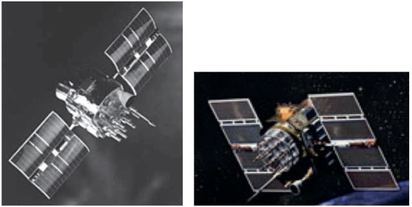
Figure 3.3. GPS Block I (left; Image Courtesy NASA/JPL-Caltech) and Block II/IIA [33] (right) satellites. Source: (Left) Reproduced withpermission of NASA. (Right) Reproduced with permission of GPS
The first operational Block IIR (“Replenishment”) satellite was launched in 1997 after the first IIR satellite was lost to a launch failure earlier that year. Block IIR satellites were functionally like IIA satellites, except that the IIR satellites were equipped with Autonav capability to maintain full system accuracy for at least 180 days. Block IIR solar panels produced 1136 W of power at end of life.
As discussed in Section 3.1.2, modernized GPS signals were being designed while Block IIR satellites were being constructed and launched. A decision was made to modify the final 8 of the planned 20 satellites, adding M-signals on L1 and L2, as well as the L2C-signal. Adding the L5-signal at a new carrier frequency was deemed too great a modification. These Block IIR-M (“Modernized Replacement”) satellites were launched starting in 2005.
When the second to the last Block IIR-M satellite was being completed, it became clear that the Block IIF (“Followon”) satellites, which were also to transmit the L5-signal, would not be ready for launch in time to satisfy the ITU requirement for bringing into use the GPS frequency filing for the L5-signal. If GPS were to miss this deadline, it would lose priority in spectrum coordination relative to other satnav systems that had subsequently filed for that frequency.
Consequently, it was decided to add a “test transmitter” to this Block IIR-M satellite to bring the L5 filing into use. Unfortunately, this modification was not properly implemented and tested, and after the satellite was launched it was found that there was a reflection within the satellite’s RF signal chain, causing a multipath-like distortion of the broadcast signals [35]. Consequently, while it succeeded in satisfying the ITU criterion for bringing the L5-signal into use, this satellite has never been made operational. Thus, there are only seven operational Block IIR-M satellites. Block IIR and Block IIR-M satellites are shown in Figure 3.4.
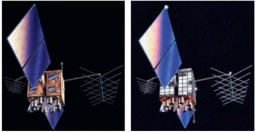
Figure 3.4. GPS Block IIR (left) and Block IIR-M satellites. Source: Reproduced with permission of GPS
Block IIF (“Followon”) satellites were designed to be the first to transmit an operational L5-signal. Block IIF solar panels provide 2440 W at end of life. At one time, modification of later Block IIF satellites to transmit higher-power regional M signals (known as a spot beam) was considered, but this modification was not pursued because of technical, schedule, and cost concerns with the basic satellites. The design life of Block IIF satellites was extended from the 7.5 years in earlier blocks to 12 years. Meanwhile, some IIA and IIR satellites had been operating for more than 20 years.
The GPS Block III program was intended to provide 32 satellites in three different sub-blocks, each providing increasing capabilities. The first eight Block IIIA satellites would develop the basic design using a satellite bus architected to enable capability growth. It would provide the Earth coverage M signals at higher power than provided by the Block II satellites, and broadcast the L1C-signal. Block IIIB and IIIC satellites would provide an M-signal spot beam, modern cross-links, and other more advanced capabilities.
Technical, schedule, and cost problems plagued the GPS Block III program, however, causing a change in plans. As of 2017, it appears that the first 10 GPS Block III satellites will all have similar capabilities. The Air Force re-competed the contract for the final 22 Block III satellites.
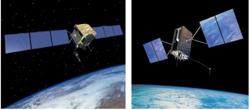
Figure 3.5. GPS Block IIF (left) and Early Block III satellites. Source: Reproduced with permission of GPS
The additional capabilities to be provided, and at what point in the procurement of these 22 satellites they will be added, have not yet been determined. Early Block III satellites have a design life of 15 years, and their solar panels produce 4480 W at end of life. Block IIF and Block III satellites are shown in Figure 3.5. Block IIIF (“Follow-on”) satellites will be introduced after the first ten Block III satellites, offering additional benefits including provision of a regional high power M-signal.
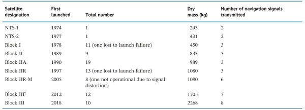
Table 3.1. Summary of GPS Satellite blocks
Table 3.1 summarizes characteristics of these satellites, showing an increase in capability with commensurate increases in mass.
Date added: 2024-08-26; views: 681;