Geoid: Earth’s Equipotential Surface, Gravity Anomalies, and Geodetic Applications
The geoid is an imaginary surface near the Earth’s surface along which the force of gravity is constant and equivalent to gravity at sea level. This so-called equipotential surface can be understood as coinciding with mean sea level and extending continuously through the continents, making it a fundamental representation of the figure of the Earth. Theoretically, the geoid exists everywhere perpendicular to the direction of gravity (the plumb line) and serves as a reference surface for geodetic measurements. If Earth were spherically symmetric and non-rotating, its gravitational equipotential surfaces would form concentric shells with increasing potential energy away from the planet, analogous to raising a ball to a higher elevation increases its potential energy.
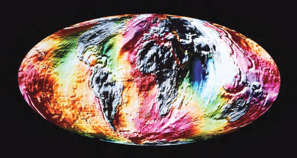
Ocean surface topography. Colors depict deviation from mean ocean surface caused by local differences in the Earth’s gravitational field. Purple is up to 280 feet (85 m) above mean, through red, orange, yellow, green, to blue (up to 345 feet [105 m] below mean)
Because Earth is not perfectly spherical—it is an oblate spheroid flattened at the poles—and because it rotates, the gravitational potential is modified accordingly. The resulting geoid is also an oblate spheroid, with its major axis approximately 0.3 percent longer than its minor axis. Geodesists, cartographers, and surveyors often use a best-fit mathematical surface (the reference ellipsoid) to approximate this spheroid. However, in many locations, the actual geoid departs from this simplified model due to non‑uniform distributions of topography and subsurface mass. These variations in gravitational attraction are known as geoid anomalies: areas of excess mass (e.g., mountain ranges or dense rock formations at depth) produce positive geoid anomalies or geoid highs, while mass deficits generate geoid lows.
The geoid is measured using a variety of techniques, including direct ground‑based gravity field measurements, tracking of satellite positions (observing deflections caused by gravity), and satellite‑based laser altimetry, which can measure sea surface height with subcentimeter precision (a fraction of an inch). Typical variations in geoid height range from several tens to about 50 feet (roughly 10–15 meters), but extreme anomalies can reach up to 450 feet (more than 100 meters). Understanding these undulations is crucial for applications such as precise navigation, climate research, and geophysical exploration.
Beyond its basic definition, the geoid represents the baseline figure of the Earth—a sea‑level surface that incorporates local gravitational effects but excludes topographic features. The geoid surface is continuous over the entire planet. Calculating this surface of equal potential energy yields a map closely resembling sea‑surface topography as measured by satellites, but without the influence of water motion. In reality, the true sea‑surface topography differs from the geoid due to ocean currents. Oceanographers exploit this relationship to map ocean circulation patterns, including complex eddies, by removing the gravitational component of sea surface height and analyzing the residual anomalies caused by moving water.
Gravity anomalies are typically categorized into free‑air anomalies and Bouguer anomalies. Free‑air anomalies correct for elevation differences above the geoid, while Bouguer anomalies further remove the gravitational effect of topography, revealing subsurface density variations. These anomaly maps are essential for identifying buried geological structures, such as sedimentary basins, volcanic intrusions, and fault systems. For example, a negative Bouguer anomaly over a mountain range may indicate a deep crustal root, consistent with the theory of isostasy—the gravitational equilibrium between Earth’s crust and mantle.
Modern geoid models are derived from a combination of satellite missions (e.g., GRACE, GOCE, and GRACE‑FO), ground gravity data, and altimetric measurements of the ocean surface. The GRACE (Gravity Recovery and Climate Experiment) mission, operational from 2002 to 2017, provided monthly global gravity field maps, enabling scientists to track mass changes due to melting ice sheets, groundwater depletion, and large‑scale ocean currents. Its successor, GRACE‑FO (Follow‑On), continues this work using laser ranging interferometry for higher precision. The GOCE (Gravity Field and Steady‑State Ocean Circulation Explorer) mission (2009–2013) delivered an exceptionally detailed global geoid model with a spatial resolution better than 100 kilometers, significantly improving our understanding of geoid undulations in regions with sparse ground data.
One of the most widely used global geoid models is EGM2008 (Earth Gravitational Model 2008) , developed by the U.S. National Geospatial-Intelligence Agency. EGM2008 resolves geoid height variations with a resolution of approximately 9 kilometers (about 5 arc‑minutes), achieving an accuracy of 10–13 centimeters over most land areas. An even more recent model, EGM2020 (released in preliminary form), incorporates additional satellite data and terrestrial measurements to further refine these estimates. These models are freely available and form the backbone of modern GPS‑based height systems, where the ellipsoidal height (from GPS) must be converted to orthometric height (height above the geoid) using a geoid model.
In practice, the difference between the reference ellipsoid and the geoid is called the geoid undulation or geoid height (N) . For example, if the geoid lies above the ellipsoid, the undulation is positive. This correction is critical for engineering projects such as tunnel construction, bridge building, and floodplain mapping, where consistent vertical reference frames are required. Many countries have adopted national geoid models tailored to their specific geology. In the United States, GEOID18 is the official model used to convert GPS‑derived ellipsoidal heights to North American Vertical Datum of 1988 (NAVD 88) heights. Similarly, the European EGG2015 (European Gravimetric Geoid) serves the EUREF (European Reference Frame) community.
Time‑variable gravity measurements from GRACE and GRACE‑FO have revolutionized hydrology and climate science. By observing how the geoid changes month to month, researchers can quantify the loss of ice mass from Greenland and Antarctica, monitor changes in terrestrial water storage (e.g., from droughts or over‑extraction of groundwater), and assess large‑scale ocean mass redistribution. These observations are independent of other remote sensing methods and provide a unique constraint on global water cycles. For instance, GRACE data revealed that the Antarctic Ice Sheet lost approximately 2,700 gigatons of ice between 2002 and 2017, contributing about 7.6 millimeters to global sea‑level rise.
In addition to satellite methods, absolute gravimeters and relative gravimeters are deployed on land and at sea to measure local gravity with high precision. Absolute gravimeters (e.g., FG5‑X models) use laser interferometry to measure the free‑fall acceleration of a test mass, achieving microgal accuracy (1 microgal = 10⁻⁸ m/s²). These instruments are used to establish gravity reference networks and calibrate satellite gravity data. Relative gravimeters, such as spring‑type or superconducting gravimeters, are more portable and suitable for field surveys but require frequent calibration against absolute gravity stations.
A practical application of geoid knowledge is in airborne gravity gradiometry, used extensively in mineral and hydrocarbon exploration. By measuring subtle variations in gravity gradients (derivatives of gravity), geophysicists can detect buried ore bodies, salt domes, and fault zones with high resolution. This technique is particularly effective in regions where magnetic or seismic methods are less conclusive, such as over basalt‑covered terrains or in arctic environments. The geoid serves as the reference datum for reducing airborne gravity data to a common level.
Finally, it is important to distinguish the geoid from other reference surfaces. The reference ellipsoid is a purely mathematical surface, while the geoid is a physical surface defined by gravity. The topographic surface includes mountains, valleys, and ocean floor features. Modern geodesy integrates all three through the concept of the quasi‑geoid (used in some vertical datums) and normal heights. Understanding these distinctions is essential for interpreting satellite altimetry, gravity field missions, and global navigation satellite systems (GNSS).
In summary, the geoid is not merely an academic abstraction but a dynamic and highly useful tool for Earth sciences. From mapping ocean currents and ice sheet loss to enabling centimeter‑level construction surveys, the geoid links gravity, shape, and height in a coherent framework. Ongoing satellite missions and ground‑based observations continue to refine our knowledge of this equipotential surface, promising even greater accuracy for future geodetic, geophysical, and environmental applications.
Date added: 2026-04-26; views: 177;