Global Positioning System (GPS)
The use of radio signals for navigation began in the early twentieth century. Between 1912 and 1915, Reginald Fessenden of Boston, Massachusetts, transmitted radio waves from designated shore- based stations to correct ship chronometers and give mariners a sense of direction.
The prospect of greater accuracy came in 1940 when Alfred Loomis of the National Defense Research Council suggested simultaneous transmission of pulsed signals from a pair of precisely surveyed ground stations to ship receivers and use of the difference in arrival times of the two signals to calculate a line of position. Developed during World War II by the Radiation Laboratory at the Massachusetts Institute of Technology, the system Loomis had proposed became known as Loran (LOng RAnge Navigation), and it supported convoys crossing the Atlantic.
Subsequent improvements significantly increased Loran accuracy, but the technology was still limited to two dimensions—latitude and longitude. Not until 1960 did Ivan Getting of Raytheon Corporation in Lexington, Massachusetts, propose the first three-dimensional type of Loran system.
Intended to solve navigational problems associated with rail-based, mobile intercontinental ballistic missiles, Raytheon’s system was called Mosaic (MObile System for Accurate ICBM Control). That system was never developed, however, because a new technology—artificial satellites— provided the basis for more precise, line-of-sight radio navigation.
The NAVSTAR (NAVigation System Timing And Ranging) Global Positioning System (GPS) provides an unlimited number of military and civilian users worldwide with continuous, highly accurate data on their position in four dimensions—latitude, longitude, altitude, and time— through all weather conditions. It includes space, control, and user segments (Figure 6).
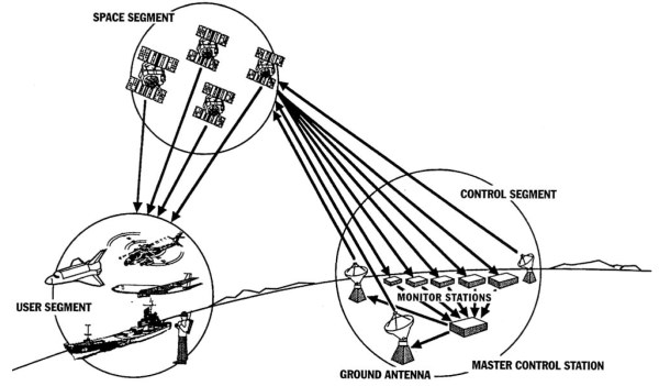
Figure 6. Major Global Position System (GPS) segments
A constellation of 24 satellites in 10,900 nautical miles, nearly circular orbits—six orbital planes, equally spaced 60 degrees apart, inclined approximately 55 degrees relative to the equator, and each with four equidistant satellites—transmits microwave signals in two different L-band frequencies. From any point on earth, between five and eight satellites are ‘‘visible’’ to the user.
Synchronized, extremely precise atomic clocks—rubidium and cesium— aboard the satellites render the constellation semiautonomous by alleviating the need to continuously control the satellites from the ground. The control segment consists of a master facility at Schriever Air Force Base, Colorado, and a global network of automated stations. It passively tracks the entire constellation and, via an S-band uplink, periodically sends updated orbital and clock data to each satellite to ensure that navigation signals received by users remain accurate. Finally, GPS users—on land, at sea, in the air or space—rely on commercially produced receivers to convert satellite signals into position, time, and velocity estimates.
Drawing the best concepts and technology from several predecessor navigation systems, engineers synthesized one that became known in the early 1970s as GPS. Those previous efforts began with Transit or the Naval Navigation Satellite System (NNSS), developed in the late 1950s by the Applied Physics Laboratory at Johns Hopkins University in Baltimore, Maryland, and used operationally by both the U.S. Navy and commercial mariners from 1962 to 1996.
Also contributing to the mix was the U.S. Naval Research Laboratory’s Timation satellite project that began during 1964 to provide very precise timing and time transfer between points on Earth. A third element originated with Aerospace Corporation’s Project 57, which included aircraft navigation using satellite signals and which the U.S. Air Force, under direction from the Advanced Research Projects Agency (ARPA), pursued as Project 621B beginning in October 1963.
The formation in 1973 of a multiservice or joint program office headed by a U.S. Air Force colonel, Bradford Parkinson, drew together these various programmatic threads led to approval from the Defense System Acquisition and Review Council (DSARC) to proceed with GPS development. This led quickly to the launch of two Navigation Technology Satellites to explore technical capabilities.
By the time the first Block I or Navigation Development Satellite was launched in February 1978, an initial control segment was functioning and several kinds of user equipment were being tested at Yuma Proving Ground on the Arizona California border.
The GPS space segment evolved steadily from the late 1970s into the 1990s. Between February 1978 and October 1985, the U.S. Air Force successfully launched and operated ten of eleven Block I satellites (Figure 7).
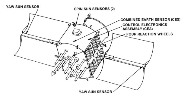
Figure 7. Global Positioning System Block I satellite diagram indicating avionics equipment
In February 1989, the first Block II fully operational GPS satellite went into orbit, and near the end of 1993, both military and civilian authorities had declared achievement of initial operational capability. With the launch of a Block IIA satellite on March 9, 1994, a fully operational, 24-satellite GPS constellation was completed. To sustain the space segment, the U.S. Air Force began launching Block IIR satellites on July 23, 1997.
The latter also enhanced performance through greater autonomy and increased protection against radiation—natural or man-made. Further improvements scheduled for 2005 with Block IIF and sometime after 2009 with Block III would make GPS less vulnerable to jamming by delivering a more powerful signal to military users. In addition, these future GPS satellites would be able to surge signals over a specific area by using spot beams and would employ new frequencies for civil ‘‘safety of life’’ applications.
Designed for use by both military and civilian parties at no charge, GPS originally offered two levels of service—precise and standard. With specially equipped receivers, authorized users could pinpoint their precise position and time with at least 22-meter horizontal, 27.7-meter vertical, and 200-nanosecond accuracy. Through a Selective Availability (SA) feature, the U.S. Defense Department could intentionally degrade GPS signals for the majority of users, who possessed standard receivers. The latter were accurate only to within 100 meters horizontally, 156 meters vertically, and 340 nanoseconds.
By 1996, however, it had become evident that the exploding market for GPS among civilians demanded greater precision. Consequently, on May 1, 2000, President Clinton announced immediate discontinuation of SA. By giving everyone access to the more precise level of service, his administration hoped to encourage private sector investment in what was already a multibilliondollar growth industry.
The uses for GPS data have become mind boggling in number and variety, as have the number of GPS devices. On the military side, the uses include aerial refueling, rendezvous operations, forward air control, location and recovery of downed pilots, targeting and delivery of precision weapons, and computer network integration.
Civilians employ GPS to manage natural resources, control maritime and land-based traffic, survey and map terrain, conduct search and rescue operations, monitor earthquakes and storms, improve athletic performance, and link communication networks and disparate databases. In automobile GPS devices alone, there was a tenfold increase from 1,100,000 units in 1996 to 11,300,000 worldwide in 2001. As GPS receivers became smaller and cheaper, they could be found in everything from cellular telephones to wristwatches.
At the beginning of the twenty-first century, GPS signals were even being used for navigation in space, and it seemed likely that aviation authorities would soon rely on an augmented GPS capability for air traffic control. Nonetheless, skeptics doubted that GPS would someday govern people’s lives to the extent enthusiasts predicted, and alarmists warned that jamming or hacking could render a GPS-dependent world militarily and economically helpless.
Supporters worried about maintaining stable funding sources for the GPS space and control segments, but critics in the U.S. Congress accused the U.S. Air Force of poor program execution as well as budgeting too far ahead of what it needed simply to sustain the system. Meanwhile, engineers pondered future GPS designs that might improve positional accuracy to 30 centimeters and time transfer to 1 nanosecond before the end of the first decade of the new century.
Date added: 2023-10-27; views: 743;