Space Segment: Satellites and Constellations
This section discusses the space segment, consisting of multiple satellites in a carefully designed and controlled constellation. Section 2.3.1 describes the basics of a satnav satellite, followed by a discussion of satnav constellations in Section 2.3.2. Section 2.3.3 introduces a specific set of constellation characteristics that are used in subsequent chapters to describe specific satnav constellations.
Satnav Satellites. Figure 2.3 shows the architecture of a satnav satellite’s payload, with an example of five signals on two carrier frequencies. Telemetry, tracking, and control (TT&C) links intermittently or continuously provide payload and bus status to the ground segment, and receive data from the ground segment. An atomic frequency standard (AFS) in the payload provides precision frequency information to the signal generator, which produces a set of satnav signals at one or more different carrier frequencies. Signals are amplified to high power, combined, and then broadcast from a transmit antenna.
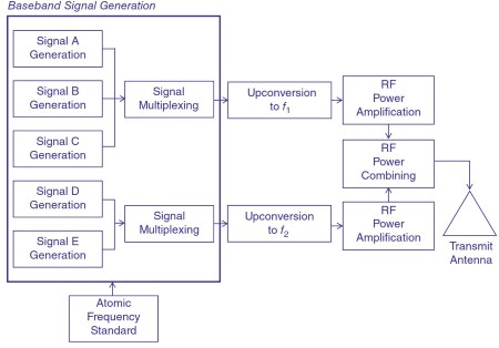
Figure 2.3 Satnav satellite payload. Source: Reproduced with permission of IEEE
Many satnav systems have adopted or are moving toward use of S band or C band for TT&C. AFS technologies include cesium, rubidium, and hydrogen maser clocks. Typically, a satellite is equipped with several of these clocks, so that if one fails it can be replaced with another. The signal generator produces satnav signals, which are described in Section 2.4. Multiple signals are typically used, often with two or more on each carrier frequency, and multiple carrier frequencies, to meet the needs of different user groups, and provide frequency diversity for robustness and to assist receivers in mitigating the deleterious effects of signal propagation.
Signals are typically formed digitally at baseband, after which those to be transmitted on the same carrier frequency are digitally combined. The resulting composite signals on each carrier frequency may then be upconverted to RF, or may be directly synthesized digitally into an RF waveform. Power amplifiers typically operate in saturated mode for highest efficiency, so the composite signals are constant envelope, motivating the use of sophisticated signal-combining approaches.
The power amplifier outputs typically have tens of watts of power. RF power combining is accomplished by a multiplexer that must handle the signals at high power, bandpass filtering around each carrier to meet the requirements for out-of-band emissions, and combining the composite signals at different carrier frequencies into a single higher-power RF waveform for transmission. Transmit antennas typically are an array of antennas - helices or patches are common - pointed at nadir. Their gain patterns may be shaped to provide higher gain at angles off nadir, to provide approximately the same received power to near the edge of Earth as at nadir. Such a gain pattern is known as isoflux.
Other satellite architectures exist, including those that use transponders, where the signal is generated on the ground, broadcast at a different carrier frequency up to the satellite, then frequency-translated on the satellite to the desired carrier frequency for the broadcast signals. Such a bent pipe configuration simplifies the satellite payload but requires continuous communication connectivity with the ground segment.
Satnav satellites are three-axis stabilized. They typically have a dry mass (not including the propellant) on the order of 1000 to almost 4000 kg. Satellite power is provided by solar arrays producing several kilowatts of power used by the bus and the payload. While the RF power entering the transmit antenna ranges from tens of watts to hundreds of watts, the transmit antenna focuses this power on the service region, providing a gain on the order of 20 to 40 (13 dBi to 16 dBi) for MEO satellites, and approximately 100 (20 dBi) for satellites at geosynchronous equitorial orbit (GEO). Thus, the effective isotropic radiated power, or EIRP (the apparent RF power when viewed from the service region), typically exceeds 500 watts for MEO satellites and 1000 watts for GEO satellites.
Satnav Constellations.As described in subsequent chapters, the first two satnav systems were designed for a global service region, as are two additional systems currently being completed. However, the space and ground segments are less complex if a satnav system’s service region covers only a portion of Earth, and several satnav systems have been or are being deployed to provide regional coverage as well.
Regardless of whether the service region is global or regional, a satnav system’s constellation is designed with several characteristics in mind:
- As seen in Section 2.2, measurements from multiple satellites are typically needed.
- Section 2.8 shows that there are accuracy benefits when these multiple measurements employ signals arriving from angles that are geometrically diverse in azimuth and elevation.
- Users typically desire continuous availability of satnav capability, so multiple satellites must be in view continuously, providing the desired geometric diversity.
- User equipment may be situated where signals cannot be received from every angle down to the horizon, so it is desirable to provide enough satellites at higher elevation angles.
- Satellites may be temporarily taken out so service, or may fail, so it is beneficial to design the constellation to provide good performance even if one or more satellites are not functional.
These capabilities motivate a constellation having many satellites, but the costs of developing, acquiring, launching, and operating the satellites is high (the United States’ GPS is said to cost more than US$1 billion peryear). Consequently, there is a strong motivation for well-designed constellations that provide these benefits with modest numbers of satellites.
Closely related to the number of satellites in the constellation is the satellite altitude. While low Earth orbit satellites can provide a given level of received power with lower RF power due to less propagation loss, hundreds of low Earth orbit (LEO) satellites would be required to service Earth with four or more satellites at reasonable elevation angles. By contrast, satellites at MEO altitudes or higher provide visibility to a much larger portion of Earth, allowing a smaller constellation - one that can provide global service with on the order of two dozen satellites.
Interestingly, the RF power needed to provide a given level of received power to the edge of Earth is essentially invariant with satellite altitude from MEO to GEO, since the transmit antenna beamwidth can be reduced at higher altitudes, increasing the transmit gain commensurate with the greater path loss.
For satnav systems having a global service region, MEO constellations are best, as shown by early studies for GPS, and confirmed by the adoption of MEO constellations for all global systems. Satellites in these MEO constellations are typically placed in three to six inclined planes, with inclinations typically exceeding 55° to provide service to receivers at higher latitudes.
Satnav systems providing regional service employ a blend of geostationary satellites and inclined geosynchronous satellites to provide an adequate number of satellites with the desired geometry over the service region. The inclinations and eccentricities of the geosynchronous orbits vary, depending upon the latitude of the service region.
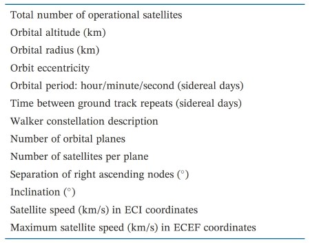
Table 2.1 Summary of nominal constellation characteristics
Constellation Characteristics. Table 2.1 lists a comprehensive set of constellation characteristics that will be employed in Chapters 3 through 8. These characteristics, while not offering sufficient detail for a precise representation of satellite locations over time, provide a useful way to compare constellation characteristics. In some cases, there may be multiple values for a given constellation, or a range of values may be more appropriate than a specific value.
Date added: 2024-08-26; views: 556;