Continents & Oceans: Atmospheric Circulation, Gyres, and Thermohaline Climate Drivers
Continents. It is evident from Figure 5.5 that the Northern and Southern Hemispheres differ in circulation. The Southern Hemisphere has contiguous bands of high pressure at latitude 30° S and low pressure at latitude 60° S, as expected from Figure 5.4. These bands are intermingled in the Northern Hemisphere. This difference arises because of the different distribution of land in the two hemispheres; 70 percent of all land is in the Northern Hemisphere. Maximum land area is between latitudes 40° N and 75° N, where more than 50 percent of Earth’s surface area is land. In the Southern Hemisphere, land is generally less than 25 percent of the surface area.
Between latitudes 40° S and 65° S, there is little land. Continents heat and cool faster than oceans. In January, when northern continents are colder than oceans, high pressure systems form over land; low pressure systems are most pronounced over the northern regions of the Pacific and Atlantic Oceans. The opposite pattern occurs in summer when northern continents are warmer than oceans. Strong high pressures develop in the North Pacific and North Atlantic; low pressures develop over Asia and North America.
Oceans. Proximity to oceans affects climate. The large heat capacity of oceans creates a thermal inertia that moderates extreme temperature fluctuations compared with interior regions of the continents. Oceans store heat in summer and release heat in winter, damping summertime warming and wintertime cooling. Like the atmosphere, the general circulation of the ocean also transports heat from the tropics to the poles. Oceanic heat transport is the result of two types of circulations: wind-driven surface currents and the density-driven thermohaline circulation.
The trade winds blowing from the southeast in the Southern Hemisphere and northeast in the Northern Hemisphere set in motion westward-flowing equatorial currents to the north and south of the equator. When these currents reach the western edge of the Pacific and Atlantic basins, they deflect and flow as western boundary currents to the north in the Northern Hemisphere and to the south in the Southern Hemisphere. Between latitudes 30° and 60° in both hemispheres, the prevailing westerly winds push surface water east across the ocean basins. At the eastern edge of the oceans, this water deflects as eastern boundary currents to the south in the Northern Hemisphere and to the north in the Southern Hemisphere.
This circulation of surface water creates circular flows in ocean basins known as gyres (Figure 5.8). These gyres are centered in the subtropics at latitudes 30° N in the North Atlantic and the North Pacific and at 30° S in the South Atlantic, South Pacific, and Indian Ocean. These gyres rotate clockwise in the Northern Hemisphere and counterclockwise in the Southern Hemisphere. At high latitudes, polar easterlies drive surface currents in a westward direction to produce subpolar gyres that rotate in a direction opposite to the adjacent subtropical gyres. These subpolar gyres develop in the Atlantic east of Greenland and in the Weddell Sea off Antarctica. In the Southern Hemisphere, the strong surface westerlies near latitude 60° S create an eastward-flowing Antarctic circumpolar gyre.

Fig. 5.8. Wind-driven ocean surface currents
Western boundary currents are strong poleward-flowing currents that carry warm water from the tropics to middle latitudes. Proximity to these warm currents creates a milder climate than would be expected from latitude. The most prominent are the Gulf Stream current along the western boundary of the Atlantic off the United States coast and the Kuroshio current along the western boundary of the North Pacific. As a result, water off western and northern Europe is much warmer than water off eastern North America at similar latitudes (Figure 5.6). Likewise, water off southeast Alaska and western Canada is warmer than corresponding water north ofJapan. In contrast, eastern boundary currents transport cold water towards the tropics. Prominent eastern boundary currents are the California current off the United States west coast, the Peru current off the west coast of South America, the Canary current off northern Africa, and the Benguela current off southern Africa.
In addition to surface currents, deep ocean currents arise from density differences in water. This circulation, called the thermohaline circulation, arises because variations in the salinity and temperature of water create differences in density. The density of water increases as temperature decreases or salinity increases. Cold, salty water is denser than warm, fresh water. Water involved in the thermohaline circulation initially forms in polar regions at the surface. In the Antarctic Ocean, surface water cools to below freezing because of the cold overlying air. When the water freezes, it forms a layer of sea ice several meters thick. Salt is excluded from the ice as it freezes, and the unfrozen water under the sea ice becomes saltier.
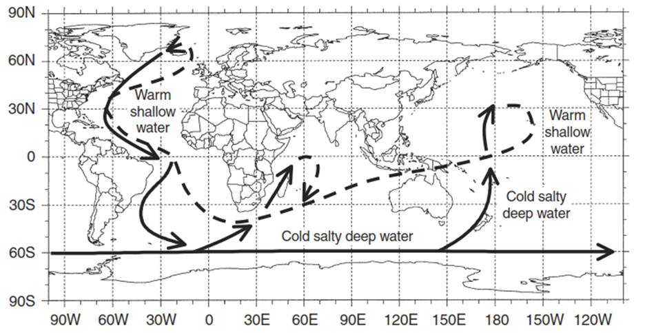
Fig. 5.9. Thermohaline circulation showing cold, salty deep water (solid lines) and warm shallow water (dashed lines)
The cold, salty water is dense, sinks to the bottom, encircling Antarctica and flowing northwards along the ocean bottom. Similar masses of cold, dense deep water form in the Arctic Ocean off the coast of Greenland, where it flows southwards along the ocean bottom into the North Atlantic. Figure 5.9 illustrates the full thermohaline circulation. In the North Atlantic, warm surface water flowing northwards becomes more dense as it cools and evaporation increases surface salinity. The dense water sinks and returns southward along the ocean bottom. Near the southern tip of Africa, this deep water joins the Antarctic bottom water. This river of bottom water spreads into the Indian and Pacific Oceans. The deep water slowly rises in these oceans and begins its long journey along the surface back to the North Atlantic.
Date added: 2025-05-15; views: 685;