The Afar Triple Junction and Mid-Ocean Ridge Spreading Centers: A Geological Analysis
Some continental rifts possess the potential to evolve into mid-ocean ridge spreading centers. The most exemplary natural laboratory for observing this transition is the Ethiopian Afar region, where the East African continental rift system converges with the juvenile oceanic spreading centers of the Red Sea and the Gulf of Aden. Within this broad plate boundary zone, three distinct plate boundaries intersect: the African/Arabian boundary (Red Sea spreading center), the Arabian/Somalian boundary (Gulf of Aden spreading center), and the African/Somalian boundary (East African rift). This intersection forms a complex structural system known as an RRR (rift-rift-rift) triple junction, characterized by extensive extensional structures where most of the Afar region resides near sea level, with isolated blocks of continental crust, such as the Danakil horst, separated by normal faults.
The Red Sea contains a juvenile spreading center that shares several characteristics with the Mid-Atlantic Ridge. Geologists classify oceanic spreading centers into two primary categories based on their surface geomorphology and topographic elevation, which are directly influenced by spreading rates. Atlantic-type ridges are defined by slow spreading rates, typically ranging from 0.2 to 0.8 inches per year (0.5 to 2 cm/yr), whereas Pacific-type ridges exhibit faster rates, generally between 1.5 and 3.5 inches per year (4 to 9 cm/yr). These divergent rates dictate the distinct structural and morphological characteristics observed along these undersea mountain ranges.
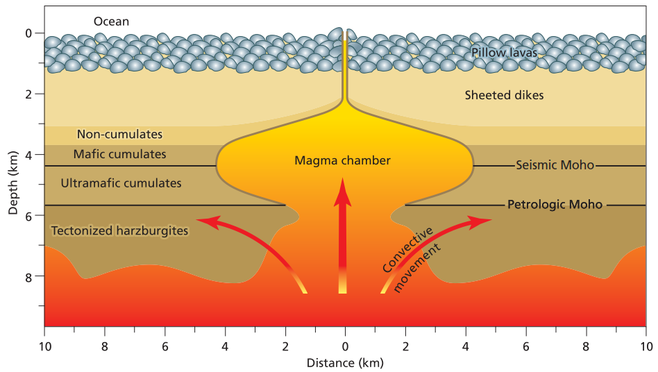
Formation of oceanic crust and lithosphere at midocean ridges. Magma forms by partial melting in the asthenosphere and upwells to make a magma chamber beneath the ridge axis. As the plates move apart, dikes intrude upward from the magma chamber and feed the lava flows on the surface. Heavy crystals settle out of the magma chamber and form layers of crystal cumulates on the magma chamber floor.
Atlantic-type ridges are characterized by a broad topographic swell spanning 900 to 2,000 miles (1,500 to 3,000 km) in width, where the seafloor rises from abyssal plains located 2.5 miles (4.0 km) below sea level to approximately 1.7 miles (2.8 km) below sea level along the ridge axis, with slopes typically less than 1°. A defining feature of these slow-spreading ridges is a prominent median rift valley, approximately 20 miles (30 km) wide at its upper margins and narrowing to 0.6 to 2.5 miles (1 to 4 km) at its deep floor. Constructional volcanoes are commonly situated along the base and inner walls of this medial rift, contributing to the rugged topography and block-faulted slopes that typify the central regions of these ridges.
In contrast, Pacific-type ridges are generally wider, spanning 1,250 to 2,500 miles (2,000 to 4,000 km), and rise 1.2 to 1.8 miles (2 to 3 km) above the abyssal plains with extremely gentle slopes of approximately 0.1°. These fast-spreading ridges lack a median valley and are instead distinguished by shallow earthquake foci, high heat flow, and low gravity anomalies along their axes, suggesting the presence of shallow magma reservoirs beneath the surface. The flanks of Pacific-type ridges are notably smoother and less faulted than their Atlantic-type counterparts, reflecting the distinct magmatic and tectonic processes associated with higher spreading rates.
The elevated topography characteristic of both ridge types results from their support by low-density, hot mantle material, a mechanism geologists term isostatic compensation. New magma upwells actively beneath the ridge axes, forming small magma chambers where crystallization produces the rocks that constitute the oceanic crust, which is added in roughly equal proportions to the diverging tectonic plates. This newly formed crust is young, hot, and relatively buoyant, allowing it to float on the underlying asthenosphere. As the crust ages and migrates away from the spreading center, it cools, thickens, and becomes denser, leading to its gradual subsidence; this process accounts for the topographic profile of ridges, with the rate of thermal subsidence being consistent across both fast- and slow-spreading systems.
Abundant volcanic activity, characterized by vast outpourings of basaltic lava, defines the axial regions of mid-ocean ridges. The lava often solidifies into distinctive pillow lavas, along with lava tubes and more massive flow forms. These axes are also sites of high heat flow, hosting numerous hydrothermal vents where seawater circulates through the oceanic crust, is heated by proximity to magma, and re-emerges onto the seafloor. These vents frequently precipitate sulfide minerals, forming tall structures known as black smokers, which discharge superheated, metal-rich fluids. These hydrothermal systems support unique ecosystems of sulfide-reducing bacteria, tube worms, and crabs, leading many scientists to hypothesize that similar environments were crucial for the origin and early evolution of life on Earth.
Geophysical seismic refraction studies conducted in the mid-20th century established that the oceanic crust possesses a consistent seismic layering structure. Seismic Layer 1 consists of unconsolidated sediments; Layer 2 is interpreted as a basaltic layer approximately 0.6 to 1.5 miles (1 to 2.5 km) thick; and Layer 3, roughly 4 miles (6 km) thick, is composed of gabbro and crystal cumulates, underlain by mantle peridotite. Exposures of deeper oceanic lithosphere, found at some ridges and transform faults, typically reveal a mafic dike complex, thick gabbroic sections, and ultramafic cumulates, with mantle rocks such as depleted harzburgite tectonites exposed in certain localities.
As tectonic plates diverge, the reduction in pressure on underlying mantle rocks induces decompression melting, producing basaltic magma from the peridotitic mantle. This magma ascends to fill the gap created by the diverging plates, forming a magma chamber where it slowly crystallizes into gabbro. Prior to complete crystallization, some magma is injected upward through dikes to form the sheeted dike complex and erupt on the seafloor as basaltic flows, including pillow lavas. Within the magma chamber, denser crystals like olivine and pyroxene settle to form layered cumulates, while the residual mantle becomes progressively deformed, forming highly strained harzburgite. This complete process of oceanic crustal accretion is observable on land in Iceland, along the Reykjanes Ridge.
Much of the detailed understanding of deep oceanic crustal structure derives from the study of ophiolites, which are fragments of oceanic lithosphere tectonically emplaced onto continents during convergent tectonic events. Investigations of ophiolites have largely validated the layered structure inferred from seismic studies while also revealing significant variations in structure and chemistry attributed to factors such as spreading rate, magma supply, and tectonic setting. Despite these insights, the majority of the ocean floor remains unexplored, with scientific knowledge of many planetary surfaces exceeding that of Earth’s own abyssal plains.
The Mid-Atlantic Ridge rises above sea level in Iceland, a location where a mantle hot spot interacts with the ridge system, resulting in the island’s average elevation exceeding 1,600 feet (500 m). The ridge traverses Iceland from southwest to northeast with a spreading rate of approximately 1.2 inches per year (3 cm/yr). The active spreading is propagated through a series of rift zones and transform faults, including the Western Rift Zone, the South Iceland Seismic Zone, and the Eastern Rift Zone, demonstrating the complex interaction between the spreading center and the underlying Iceland plume.
Over the past 6 million years, the Iceland hot spot has drifted relative to the North Atlantic, causing the active ridge system to adjust through a series of small jumps to remain coincident with the plume of thermally weakened mantle. These ridge jumps have resulted in the remelting of older crust, producing diverse volcanic rocks, including alkalic and silicic compositions, which overlie older oceanic basalts. Active spreading is currently accommodated by fissure swarms and graben, with intense hydrothermal activity and episodic magma intrusion from shallow crustal chambers. Iceland’s geological record includes numerous Holocene eruptions, often interacting with the island’s extensive glacier systems to produce explosive phreatomagmatic activity and catastrophic glacial floods known as jökulhlaups, while the high geothermal gradients provide a critical resource for geothermal energy.
Date added: 2026-04-26; views: 182;