
Anthropogenic Vegetation Change and Global Land-Use History
Human Impacts on Global Vegetation and Landscape Dynamics. Human activities represent a primary agent of terrestrial ecosystem transformation, re-engineering natural biomes and generating complex spatial landscape patterns across the globe. The anthropogenic clearing of native forests and natural grasslands for agricultural expansion has precipitated a substantial loss of pristine ecosystems worldwide, converting contiguous natural habitats into fragmented ecological mosaics. Global land-use estimates indicate that approximately 18 million km² of land (representing 12% of the global land surface) is currently dedicated to cropland, while an additional 34 million km² (22% of the global land surface) is utilized for pastureland and rangeland (Figure 2.8).
Geographic Distribution of Major Crop Types. The spatial arrangement of global cultivated land is characterized by distinct regional crop dominances tailored to climate conditions and agricultural systems. Wheat (Triticum spp.) stands as the most abundant cultivated crop globally, covering 22% of total worldwide cropland (Figure 23.7). Wheat cultivation is extensive across the middle latitudes of North America, Europe, and Asia, alongside significant agricultural concentrations in parts of India and Australia. Maize (Zea mays) represents the second most abundant crop type, occupying 13% of global cropland across both the Northern and Southern Hemispheres.
Global Crop Patterns. Rice (Oryza sativa) occupies 11% of global cropland area, concentrated heavily across agricultural landscapes in India and Southeast Asia. Barley (Hordeum vulgare), accounting for 9% of global cropland area, is primarily cultivated in the cold-climate agricultural zones of Canada, the northern United States, and Northern Europe. Soybeans (Glycine max) cover 5% of total crop area, while pulses (comprising dry beans and peas) account for 4% of global cropland. A diverse group of 12 other major crop types collectively comprises the remaining 21% of worldwide cultivated area (Fig. 23.7).
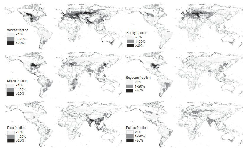
Fig. 23.7. Geographic distribution of the six most common crops in terms of percentage area. Adapted from Leff et al. (2004). See also Monfreda et al. (2008).
Historical Patterns of Global Land Clearing. The global geography of land clearing closely mirrors historical trajectories of human population growth (Pongratz et al. 2008; Klein Goldewijk et al. 2011). High concentrations of cropland emerged in the Mediterranean basin, the Middle East, and India as early as CE 800 (Figure 23.8). Widespread forest clearance in Europe progressed throughout the Middle Ages and earlier historical epochs, whereas extensive deforestation in the United States accelerated rapidly alongside European settlement during the 1600s and 1700s. In contrast to these historic high-latitude cleared regions, tropical biomes are currently experiencing the world's most rapid rates of widespread deforestation.
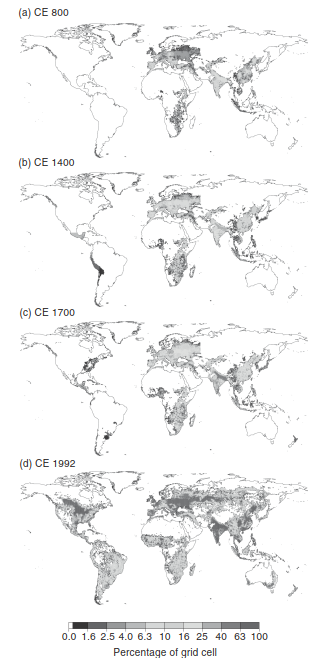
Fig. 23.8. Global historical cropland for the years CE 800, CE 1400, CE 1700, and CE 1992 in terms of percentage area. Reproduced from Pongratz et al. (2008) and provided courtesy of Julia Pongratz.
European Deforestation Trajectories. Anthropogenic Landscape Transformation in Europe. Much of the indigenous vegetation of the European continent has been cleared to accommodate agricultural expansion. Forest clearance in Europe is documented as far back as the Neolithic culture 5000 years ago, when primary forests were felled for permanent settlement, crop cultivation, and livestock grazing (Darby 1956; Kirby and Watkins 1998; Williams 2000, 2003; Kaplan et al. 2009; Hughes 2011). However, the pace and geographical extent of deforestation accelerated significantly throughout the Mediterranean region during the Classical period of ancient Greece and Rome.
Classical Exploitation and Forest Cover Loss. Maritime shipbuilding, timber utilization for structural construction and fuel, agricultural clearance, and livestock overgrazing drove widespread forest depletion across the Mediterranean basin during classical antiquity. Prominent Classical scholars including Homer (ninth century BCE), Plato (fourth century BCE), and the Roman philosopher Lucretius (first century BCE) each documented severe contemporary forest loss. Subsequently, rapid demographic growth across central and western Europe during the Middle Ages intensified woodland removal, prompting legal conflicts between forest conservation and exploitation by the end of the twelfth century. While approximately 80% of temperate western and central Europe was forested in CE 500, less than half of these forests survived by CE 1300, and forest cover in central Europe dropped to just 25% by 1900 (Williams 2003). Overall, Europe experienced profound forest depletion over the last 2000 years (Figure 23.9).
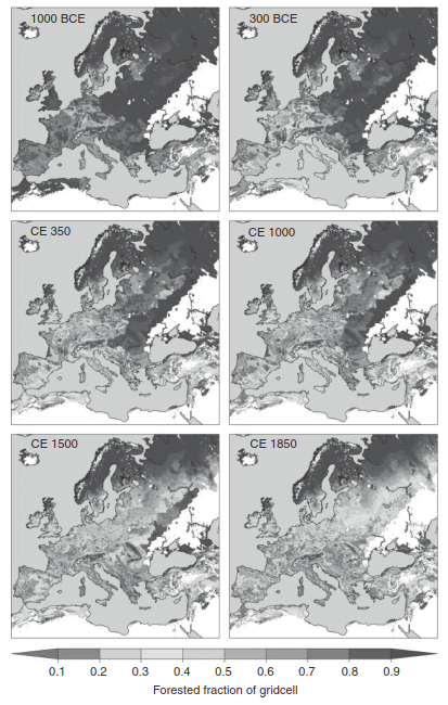
Fig. 23.9. Historical forest clearance maps for the years 1000 BCE, 300 BCE, CE 350, CE 1000, CE 1500, and CE 1850. Reprinted from Kaplan et al. (2009) with permission from Elsevier.
Palynological Evidence of Environmental Reconstruction. Long-Term Vegetation Shifts in East Anglia. Palynological reconstructions from a pollen sequence collected in central East Anglia (between Cambridge and Norwich) provide a continuous record of anthropogenic vegetation impacts spanning the past 10,000 years (Table 23.2). Located in the agricultural heartland of the United Kingdom, this region relies heavily on local grain marketing, milling, and malting industries established during medieval times, alongside historic regional hemp cultivation.
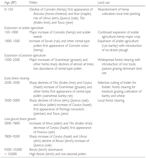
Table 23.2. Pollen chronology in central East Anglia from present to 10,000 years before present (Source: From Peglar et al. 1989).
Holocene Ecological Transitions. The initial 5000 years of the East Anglia sequence (10,000–5000 years BP) document late-glacial vegetation development and forest succession as tree species recolonized the post-glacial landscape. By 5000 years BP, the natural landscape formed a mosaic of deciduous woodlands dominated by linden (Tilia) and oak (Quercus), alongside elm (Ulmus), ash (Fraxinus), hazel (Corylus), and alder (Alnus). Anthropogenic disturbance initiated approximately 5000–3500 years BP, marked by a pronounced decline in elm (Ulmus) due to Neolithic forest clearance, corresponding with an expansion of hazel (Corylus) and ruderal herbaceous species like plantain (Plantago lanceolata).
Prehistoric and Historic Land-Use Transitions. Between 3500 and 2500 years BP, palynological records demonstrate marked reductions in linden and hazel pollen, accompanied by increases in herbaceous grasses and the initial appearance of cereal-type pollen. The period from 2500 to 1500 years BP experienced widespread forest clearance—potentially leading to complete local deforestation—driven by pastoral expansion and facilitated by the advent of iron tools for land clearing and timber harvesting for iron smelting. Arable agriculture expanded substantially between 1500 and 150 years BP, marked by extensive rye (Secale) and barley (Hordeum) cultivation, ox-drawn ploughing, and major hemp (Cannabis sativa) farming, which subsequently declined in the industrial era (1800s) as tree planting initiatives began (Table 23.2).
Regional Micro-Histories of European Woodland Decline. Sub-Regional Forest Clearance Dynamics. Specialized regional studies illustrate parallel trajectories of land-use change across Europe. In the English Lake District in Cumbria, extensive broadleaf deciduous forests dominated by oak (Quercus) and linden (Tilia) covered the region prior to CE 900 (Barker 1998). Overgrazing by livestock and timber exploitation reduced forest cover between CE 900 and 1800, initiated by Norse invasions (CE 900–1000), sustained by monastic sheep grazing (CE 1100–1500), and intensified by charcoal production for iron smelting during early industrialization (CE 1607–1800).
Landscape Dynamics in the Low Countries. Historical analyses of the Dutch landscape reveal continuous deforestation beginning in the Neolithic Period, accelerating during the Late Bronze Age, Early-to-Middle Iron Age (1100–250 BCE), and Medieval Period (circa CE 1000) (Dirkx 1998; Spek 1998; van Laar and den Ouden 1998; Wolf 1998). Centuries of swine, cattle, and sheep grazing combined with fuelwood gathering converted vast woodlands into open heathlands, reducing forest cover in the Netherlands to just 4% by 1800 before private and government reforestation efforts initiated recovery in the 1900s.
Historical Land-Use Trends in Flanders and Ardennes. Similar historical trajectories occurred across Flanders (covering 11,000 km² across Belgium, France, and the Netherlands) and the Belgian Ardennes (Tack and Hermy 1998; Petit and Lambin 2002):
- Initial forest clearing by Celtic populations began as early as 700–55 BCE.
- Widespread deforestation occurred during the Roman era (CE 50–400) for timber procurement and agricultural production.
- Extensive forest clearing persisted from CE 1000 to the mid-1800s due to population growth and agricultural demand.
- Forest cover in Flanders dropped to 10% by 1250 and reached a historical low of 6% by 1880 before government conservation policies catalyzed forest recovery during the late 19th and 20th centuries.
Date added: 2026-09-24; views: 1;