El Niño, La Niña, and the Walker Circulation: Impacts on Global Climate and Weather Patterns Explained
In contrast to the meridional circulations depicted in Figure 5.4, the Walker circulation is a prominent zonal circulation across the tropical Pacific Ocean (Figure 7.4). It is characterized by low-level easterly winds (trade winds) and upper-level westerly winds across the tropical Pacific, ascending motion in the western basin and descending motion in the eastern basin. This zonal circulation is associated with a strong temperature contrast across the Pacific basin.
The trade winds drive warm surface water westward across the tropical Pacific with the result that surface water in the western tropical Pacific is normally several degrees warmer than water in the eastern tropical Pacific (Figure 7.5) . The western Pacific near Australia and Indonesia has an extensive pool of warm surface water with temperatures in excess of 28°C. In contrast, water in the eastern Pacific off the Peruvian and Ecuadorian coast of South America is several degrees cooler, because deep cold water replaces the warm surface water. Surface air in the western tropical Pacific, heated by the warm seas, rises (low surface pressure). The ascending warm, moist air forms deep clouds that produce heavy rains over northern Australia, Indonesia, and the Philippines. Colder air in the eastern tropical Pacific descends (high surface pressure). Rainfall is light in this region of subsidence.
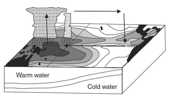
Fig. 7.4. Main features of the Walker circulation, from December to February, during normal conditions. Shading indicates progressively warmer sea surface temperature
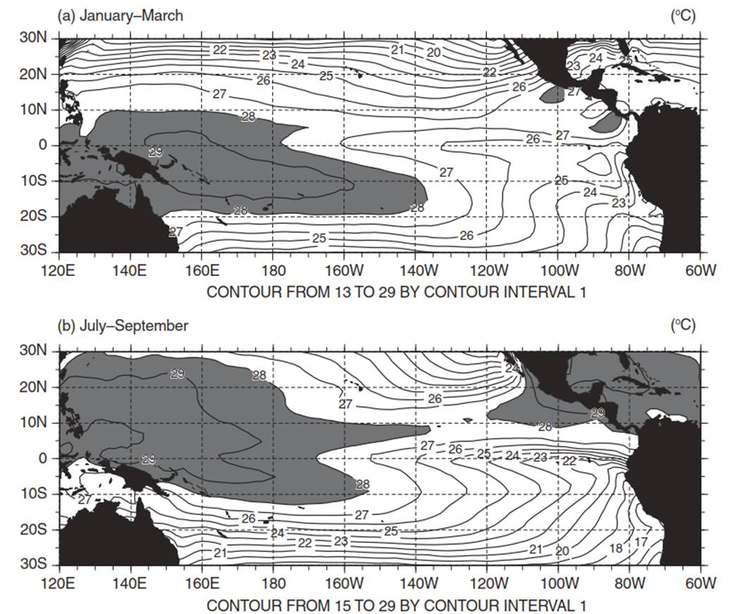
Fig. 7.5. Climatological sea surface temperature (1950–1998) for the equatorial Pacifi c between latitudes 30° S and 30° N during (a) January–march and (b) July–September. Temperatures greater than 28°C are shaded. Data provided by the national Center for atmospheric Research (boulder, Colorado)
Every few years this pattern changes, and there is a large-scale warming of sea surface temperature in the tropical Pacific east of the dateline known as El Nino. This period of higher than normal sea surface temperature is often followed by a cold phase (La Nina) in which waters in the eastern Pacific have below normal temperature. El Nino, or warm episodes, and La Nina, or cold episodes, are opposite extremes of the El Nino/Southern Oscillation cycle. El Nino refers to the warming of surface waters while Southern Oscillation refers to changes in the Walker circulation. El Ninos typically last 6 to 12 months and recur every few years. Historical records show El Nino has occurred periodically over the past several thousand years (Masson-Delmotte et al. 2013).
Abnormally warm sea surface temperatures across the eastern equatorial Pacific characterize El Nino. During a strong El Nino such as in 1998, the 28°C isotherm extends well east of the dateline and ocean temperatures are more than 2-3°C warmer than normal between the dateline and the west coast of South America (Figure 7.6 a,b). During El Nino episodes, the normal contrast between high pressure over the eastern tropical Pacific and low pressure over the west, which drives the easterly trade winds, diminishes. This is seen in the Southern Oscillation Index, which quantifies the difference in sea level pressure between Tahiti and Darwin, Australia. Prolonged periods of a negative phase, with below normal air pressure at Tahiti and above normal air pressure at Darwin, coincide with abnormally warm water in the eastern tropical Pacific.
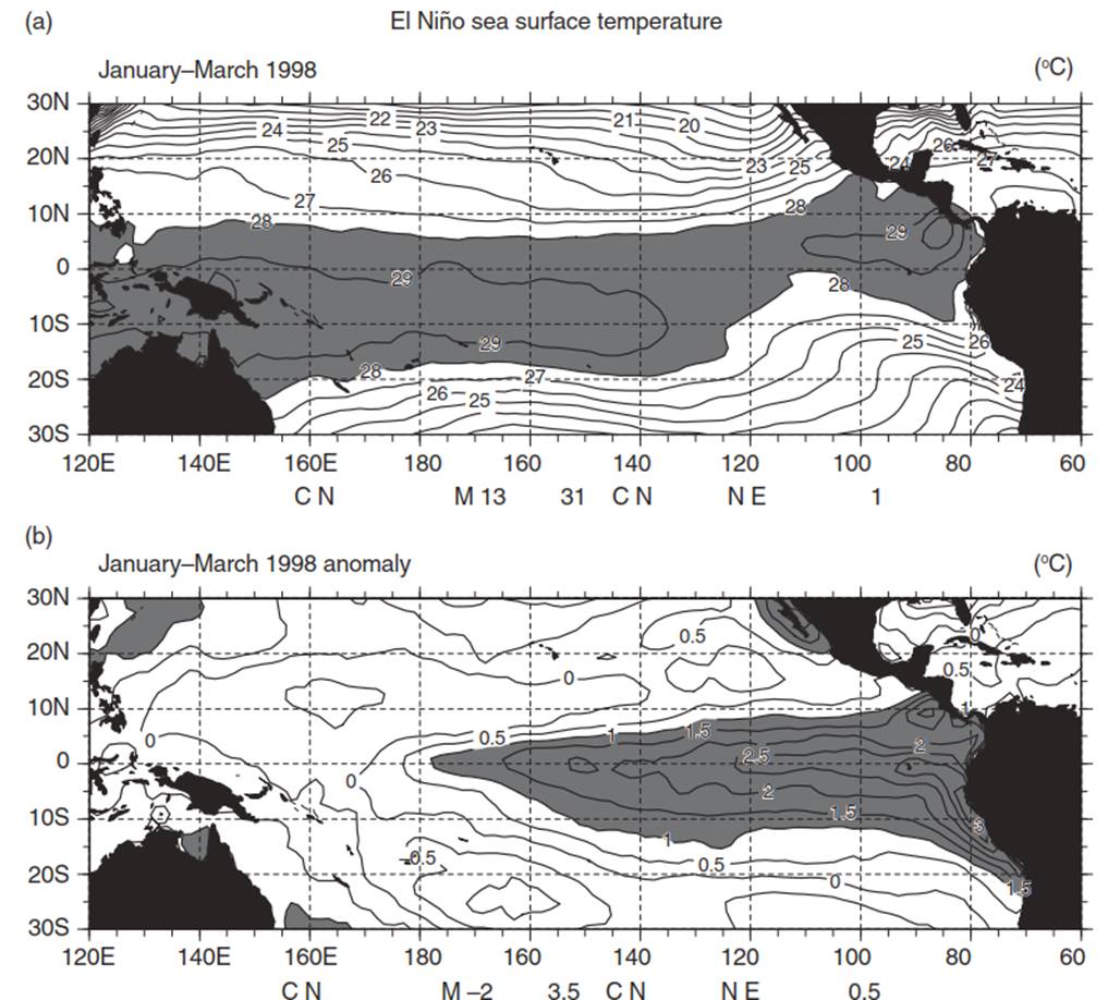
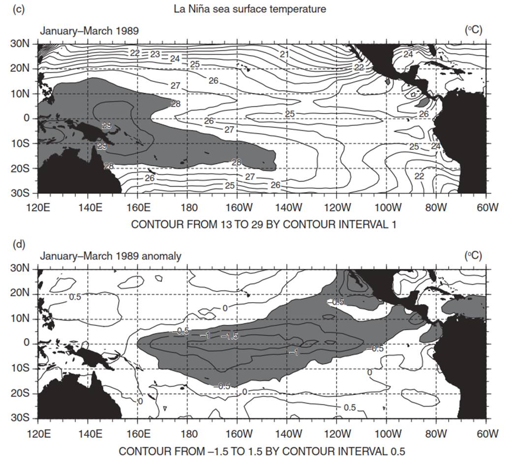
Fig. 7.6. Sea surface temperatures (January–march) in the Pacifi c for the 1998 el niño and 1989 la niña. (a) Observed sea surface temperature during the 1998 el niño. Temperatures greater than 28°C are shaded. (b) Difference from the climatological mean. Temperature anomalies greater than 1°C are shaded. (c) Observed sea surface temperature during the 1989 la niña. temperatures greater than 28°C are shaded. (d) Difference from the climatological mean. temperature anomalies less than –0.5°C are shaded. Data provided by the national Center for atmospheric Research (boulder, Colorado)
This reflects a reduced strength of the Walker circulation (Figure 7.7a). Higher than normal air pressure in the west over Indonesia and northern Australia and lower than normal air pressure in the eastern tropical Pacific weakens the trade winds; warm water drifts further east, from the dateline to South America. Rainfall patterns follow the warm water, with dry conditions over northern Australia, Indonesia, and the Philippines and heavy rains along the equator from the dateline east to the South American coast where sea surface temperatures reach 28°C or more (Figure 7.8a).
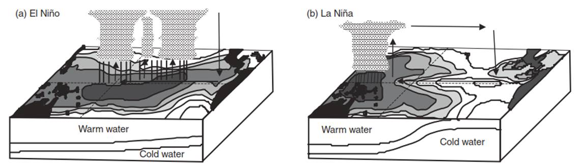
Fig. 7.7. Changes in the Walker circulation during (a) el niño and (b) la niña. Shading indicates progressively warmer sea surface temperatures

Fig. 7.8. Contrast in precipitation (January–march) across the tropical Pacifi c between (a) the 1998 el niño and (b) the 1989 la niña. Data provided by the national Center for atmospheric Research (boulder, Colorado)
La Nina episodes feature abnormally cold surface water. During a strong La Nina such as in 1989, the 28°C isotherm is restricted to west of the dateline along the equator and sea surface temperatures are a few degrees below normal between the dateline and western South America (Figure 7.6c,d) . During La Nina episodes, air pressure is lower than normal over Indonesia and higher than normal over the eastern tropical Pacific (a positive Southern Oscillation Index). This reflects an enhanced Walker circulation (Figure 7.7b). The strong east-to-west pressure difference drives strong easterly surface winds across the Pacific from the Galapagos Islands to Indonesia. The warm pool of surface water does not drift eastwards across the dateline. As a result, the equatorial Pacific from the dateline to South America is extremely dry while northern Australia, Indonesia, and the Philippines receive heavy rainfall ( Figure 7.8b).
El Nino is a cyclically recurring event in which small changes in the strength of the easterly surface winds along the equator lead to changes in oceanic circulation. This affects sea surface temperatures and rainfall, which feed back to affect the strength of the easterlies until a mature El Nino is established. The El Nino cycle represents a coherent, large-scale fluctuation in ocean temperature, rainfall, air pressure, and atmospheric circulation across the tropical Pacific. The shifts in tropical atmospheric circulation alter global atmospheric circulation and influence temperature and precipitation worldwide. These changes are most apparent between December and February, though there are important patterns throughout the year (Figure 7.9a).
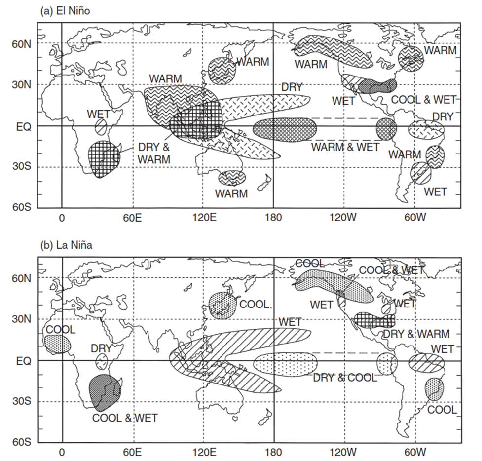
Fig. 7.9. Changes in temperature and precipitation for the December–February season during (a) el niño and (b) la niña. Source: Climate Prediction Center (national Centers for environmental Prediction, national Oceanic and atmospheric administration, Washington, DC)
During this time, wetter than normal conditions occur along the northwest coast of South America, southern Brazil and central Argentina along the southeast coast of South America, and central east Africa. California and the Gulf Coast of the United States also tend to be wetter than normal. Drier than normal conditions occur over northeast South America and southern Africa. Temperatures are warmer than normal across southern Africa, southeast Asia, southeastern Australia, Japan, southern Alaska, much of Canada, and southeastern Brazil. Cooler than normal temperatures occur in southeastern United States. The opposite patterns generally occur during La Nina (Figure 7.9b).
Date added: 2025-05-15; views: 1191;