
The Zagros and Makran Mountain Ranges: Geology, Tectonics, and Seismic Activity
The Zagros Mountain Range constitutes a massive folded mountain system spanning western and southern Iran, extending approximately 1,100 miles from the Turkish-Russian-Iranian border to the Zendan Fault north of the Strait of Hormuz. This orogenic belt continues eastward through the Makran Mountains, traversing the Baluchistan regions of Iran, Pakistan, and Afghanistan. Collectively, these ranges delineate the southern and western margins of the Iranian Plateau, acting as a formidable barrier to the Dasht-e Kavir and Lut Desert expanses. The northwestern sectors of the Zagros feature forested, snow-capped peaks and numerous volcanic cones, while the central Zagros is distinguished by parallel, cylindrical folded ridges and intervening interridge basins.
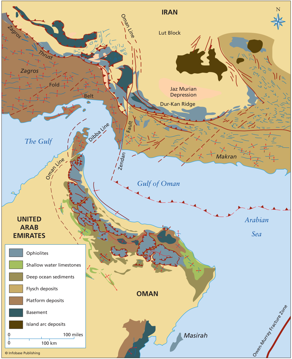
Tectonic map of parts of Iran, Afghanistan, and Arabia showing the Zagros, Makran, and Oman Mountains
Significant climatic and morphological contrasts exist along the strike of these ranges. The southwestern Zagros and the Makran ranges exhibit more subdued topography characterized by extensive exposures of bare rock, sandy sand dunes, and low-lying salt marshes. This region holds substantial economic importance, as many of Iran's major oil fields are located within the western foothills of the central Zagros. Here, subsurface salt domes have pierced overlying sedimentary strata, creating prolific structural traps for hydrocarbon accumulation. This geological configuration is a direct result of the region's prolonged and complex tectonic history.
The tectonic evolution of southwestern Iran is that of an active continental margin persisting since the Mesozoic era, involving multiple phases of magmatic activity. These igneous events are causally linked to the subduction of Tethyan oceanic crust beneath the continental fragment. An early phase, during the Late Cretaceous, generated magmatism in the Makran above a subducting slab associated with the Oman ophiolite preserved on the Arabian margin. Subsequently, the axis of active volcanism migrated inland during the late Eocene, only to shift back toward the trench in the Oligocene-Miocene period.
The Oligocene-Miocene magmas are also genetically related to oceanic crust subduction, a key indicator that the definitive Arabian-Iranian continental collision did not initiate until the Miocene. This timing explains fundamental lithological differences between the adjacent mountain belts. The southern Zagros primarily comprises folded continental margin sediments of the Arabian Platform, deformed since the Miocene and predominantly during the Pliocene. Conversely, the Makran represents an oceanic accretionary wedge, a prism of deformed sediments scraped off the downgoing plate.
The Makran accretionary wedge consists of intensely folded Cretaceous to Eocene sequences, including flysch deposits and ribbon-chert-bearing mélange, overriding the subducting oceanic crust of the Gulf of Oman. Thrust over this assemblage is a substantial ophiolitic sheet, part of an extensive ophiolitic belt spanning the length of the Makran-Zagros suture. This belt marks the boundary between the Cenozoic volcanics and the accreted or folded rocks to the south. The principal distinction between the two ranges stems from their collisional status: continent-continent collision is ongoing in the Zagros, whereas oceanic subduction continues unabated in the Makran.
This active tectonism renders Iran a profoundly seismically active country, tragically exemplified by the devastating magnitude 6.7 Bam earthquake on December 26, 2003. This event destroyed the ancient citadel of Bam and resulted in an estimated 50,000 fatalities. The Zagros fold-and-thrust belt exhibits intense seismic activity, where thrust-style earthquakes nucleate at depth beneath a near-surface, ductile layer of folded sedimentary rocks. The Makran accretionary wedge is likewise seismogenic, particularly along the complex interface between the subducting slab and the overriding wedge.
The transitional boundary between the Makran and Zagros is a zone of pronounced structural complexity, accommodated by numerous strike-slip faults like the Zendan Fault system. The 2003 Bam earthquake was itself a strike-slip earthquake, rupturing within this regional network of faults. Furthermore, the Central Iranian Plateau is seismically active, experiencing large-magnitude earthquakes capable of generating surface ruptures. This widespread seismic hazard underscores the dynamic and ongoing crustal deformation processes shaping the entire region, driven by the relentless convergence of the Arabian and Eurasian tectonic plates.
Date added: 2026-07-14; views: 158;