
Kuwait: Geography, Geology, and Climate of the Northwestern Arabian Gulf
Kuwait is situated in the northwestern Arabian Gulf, geographically positioned between 28°30' and 30° north latitude and 46°30' to 48°30' east longitude. It encompasses an area of approximately 17,818 square kilometers (10,700 sq mi), with a maximum north-south extent of 200 kilometers (120 miles) and an east-west extent of 170 kilometers (100 miles). The nation shares its southern border with Saudi Arabia and its western and northern borders with Iraq. Its climate is distinctly semiarid, characterized by a long, hot, and humid summer and a relatively short, cool winter.
Summer temperatures in Kuwait range from 29°C to 45°C (84.2°F to 113°F), accompanied by high humidity levels. The prevailing northwesterly shamal winds often bring severe dust and sand storms from June to early August, with gusts reaching 100 km/hr (60 mph). Winter temperatures range from 8°C to 18°C (46.4°F to 64.4°F). Occasionally, hot, dry simoom winds (from the southwest in November) can cause dangerous heat stress. Average annual precipitation is low at 114 mm (4.5 inches), occurring mainly in sudden winter squalls that rapidly infiltrate the sandy soil, leaving little surface water.
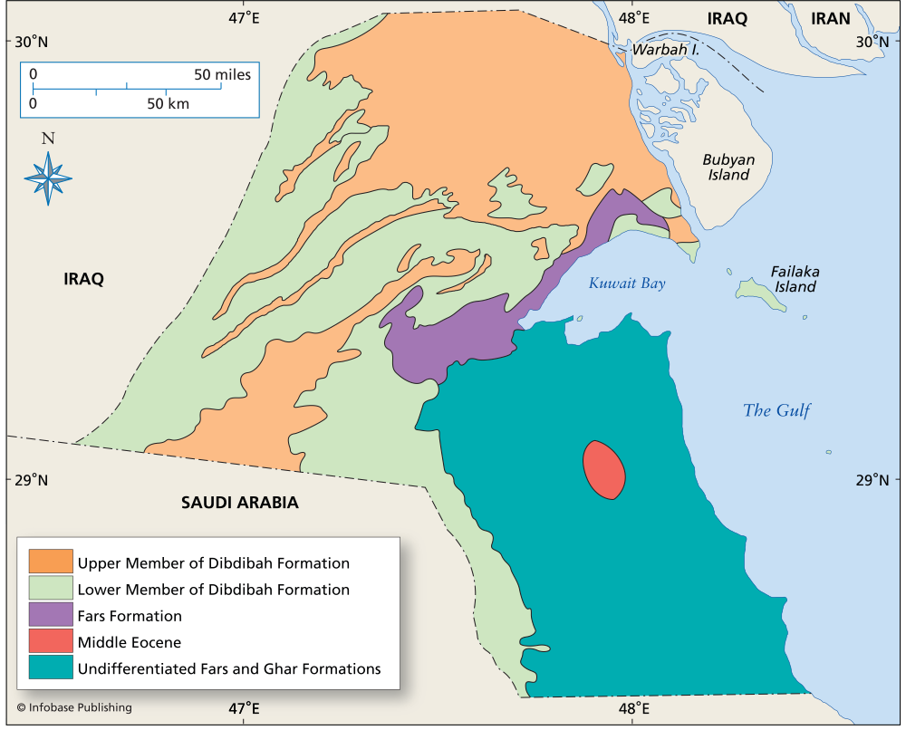
Geologic map of Kuwait
Topography and Terrain Features. Most of Kuwait comprises a flat, sandy desert, sloping gently from a maximum elevation of 300 meters (980 feet) in the southwest near Shigaya down to sea level. The country lacks mountains and rivers and can be divided into two primary regions. The northern part is a hard, stony desert with shallow depressions and low northeast-southwest trending hills, including the principal Jal al-Zor (145 m) and Liyah ridges. The southern region is a vast, treeless sandy plain, with the Ahmadi Hills (125 m) being the notable exception.
Significant valleys include Wadi Al-Batin, a broad depression along the western border with Iraq, and Ash Shaqq in the south. The landscape features small, intermittent playas (enclosed basins) that temporarily hold water and vegetation. Sand dunes are not widespread; notable occurrences include crescent-shaped barchan dunes near Umm Al-Neqqa and longitudinal dune belts near Al-Huwaimiliyah. Both mobile and stable sand sheets exist, with a major mobile belt crossing the country northwest to southeast.
Coastal Geography and Islands. The coastline is dominated by Kuwait Bay, a 40-km (25-mile) indentation featuring marshes, lagoons, and a mix of sandy beaches and sabkhas (salt-encrusted flats). The shallow northern bay contrasts with the deeper, port-hosting southern section. Kuwaiti territory includes ten islands. The largest are Bubiyan and Warba, both low-lying and connected to the mainland. Failaka Island is the only inhabited one, featuring a small village on its northwestern hill. Other islands include Miskan, Auhah, Al-Qurain, Umm Al-Naml, Qaruh, Kubbar, and Umm Al-Maradim, the latter two surrounded by reefs.
Geological Structure and Petroleum Resources. Kuwait lies on the stable Arabian Platform within the subsiding foreland of the Zagros Mountains. Its petroleum wealth is linked to major subsurface structures, primarily the north-trending Kuwait Arch and Dibdibba Arch, part of the regional Arabian Folds system. These arches, likely originating from Precambrian basement features and amplified by salt diapirism, host the nation's principal hydrocarbon accumulations. The stratigraphic column consists of a near-continuous Cambrian through Holocene sequence of Arabian Platform sediments, primarily carbonates, evaporites, and clastics, reaching 6-7 km (3.5-4 miles) thick.
Younger, northwest-trending anticlines like the Ahmadi Ridge and Bahra Anticline, formed by Zagros collision forces post-Eocene, exert secondary control on oil reservoir distribution. The Kuwait Arch achieves maximum relief in the Burgan-Bahra region, creating major oil fields. Wadi Al-Batin is a significant topographic and structural feature, bounded by faults related to Tertiary extension and filled with Quaternary and Tertiary gravels transported from the Arabian interior. Faulting along the wadi indicates structural control on ancient drainage patterns. The superposition of these deep and shallow structures creates considerable subsurface relief, crucial for hydrocarbon trapping.
Environmental and Surface Processes. Desert vegetation, critical for stabilizing sand sheets, has been severely damaged by overgrazing and off-road vehicles, converting stable areas into mobile sand. Conversely, traffic restrictions in areas like the Burgan oil field have allowed vegetation recovery and dune stabilization. The interplay of aeolian processes, limited hydrology, and human activity continues to shape Kuwait's dynamic surface environment, while its profound economic geology is dictated by the complex structures hidden deep beneath its desert plains.
Date added: 2026-07-14; views: 150;