
Importance of temporary waters in the landscape
Exactly how extensive temporary waters are in the global landscape is difficult to assess as few surveys of these habitats, per se, have been made. However, wetlands are better known and can reasonably be used as a model for examining the extent of regions of the world where conditions likely to support some types of temporary waters occur. Table 1.4 provides an overview of major wetland areas. Clearly, temporary waters are highly varied, widely distributed, and a dominant feature of our planet, occurring across virtually all continents and in all climatic zones. Further, some, such as the floodplains of tropical South America are regarded as major sites of speciation—as plants and animals respond to the flood pulse via morphological, physiological, and other adaptations (Junk 1993).
Africa. Swamps of the Upper Nile; the Rift and High altitude lakes of Eastern Africa; the Niger and its floodplains; the Lower Senegal Valley; coastal lagoons of the Ivory Coast; Lake Chad (West Africa); the vast floodplains of the south, including the Pongolo River floodplains, the Mkuze Wetland System, the Nyl River floodplains, and various pans and dambos; the internal deltas of rivers (e.g. Timbuktu in Mali and the Lorian Swamp in Kenya). There are also temporary habitats associated with various man-made lakes.
Mediterranean(southern Europe and North Africa). A large array of geomorphological formations that support wetlands, including river deltas (widely distributed from Spain to Greece); coastal lagoons (extensive around the Mediterranean Sea and along the Atlantic coast of Morocco); riverine floodplains (various oxbow lakes, for example the Rhone area); floodplain marshes (e.g. the River Tejo, Portugal, the Languedoc and Crau regions of France; and flooded woodlands, for example the Moraca River, Yugoslavia and the River Strymon, Greece); freshwater lakes (e.g. those of glacial origin in the Sierra Nevada, the Pyrenees, Apennines and Alps, and also Morocco; those associated with volcanic activity, such as the calderas of Italy; and those of karstic origin, such as those found in Albania, Yugoslavia, northwestern Greece, southern France, Spain, Algeria and Tunisia); man-made reservoirs (e.g. on the rivers Guardiana and Tejo, western Spain, the Esla Reservoir in central Spain, and Lake Boughzoud in Algeria); salt basins (restricted to the Maghreb and central Spain); intertidal regions (localized along the Atlantic coast); and seasonally flooded channels (very extensive: 75% of first order streams in southern France are believed to be seasonal and in Morocco and Tunisia the incidence for first- and second- order streams is 97%, and 80% for third and fourth order streams).
Australia(northern Australia). Along the Queensland coast, upland areas contain seasonal wetlands: floodplain lakes, billabongs (oxbow lakes), swamps, waterholes, and river flats subject to flooding; there are also extensive mangroves and tidal flats. Lowlands along the Gulf of Carpenteria support intermittent swamps in shallow pans and seasonal billabongs. Waterholes, seasonal swamps and floodplain lakes skirt the Arnhem Land Plateau, and the coastal plains east of Darwin have extensive floodplains. In Western Australia (Pilbara Area), there are numerous waterholes along river channels and also intermittently flooded lakes. The large inland arid region, which occupies almost 50% of the continent, is characterized by saline intermittently flooded and episodic wetlands.
Papua New Guinea. This predominantly high-rainfall country supports the following wetland types: saline and brackishwater swamps (including mangrove); freshwater swamps (including seasonal swamp forest and woodland, swamp savanna and herbaceous swamps). These habitats occupy around 7.5% of the land area.
South Asia(India and southeast Asia). All climatic zones support wetlands, a large percentage of which are seasonal due to the long dry summer. Many are saline (mangroves), and among the world's largest such habitats. Freshwater wetlands are dominated by shallow lakes, ponds and temporary waters. Major and medium-sized rivers all support extensive floodplain wetlands, many of which have been converted into paddy fields and fish ponds.
Canada and Greenland. Wetlands are estimated to comprise some 14% of the land area of Canada, with peatlands accounting for 88% of that figure. They variously include marshes (both freshwater and saline), shallow open water, bogs, fens and swamps, ranging through seven bioclimatic zones: arctic, subarctic, boreal, temperate, prairie, mountain and coastal. Greenland supports shallow open water, salt marshes, bogs and fens.
United States. The United States supports a vast array of wetland types, which range from those found in tropical rain forests (Hawaii), to those of wet tundra (Alaska), and those found in deserts (Southwest). Wetlands have been subdivided into five ecological groups: marine (e.g. pools on rocky shores); estuarine (e.g. salt and brackish marshes, mangrove areas); riverine (e.g. intermittent streams and shallow rivers); lacustrine (e.g. temporary ponds of various types, shallow lakes, reservoirs); and palustrine (e.g. inland marshes, wet meadows, bogs, swamps, flooded forests).
Mexico. Estuarine and marine wetlands are the most extensive, ranging along the 10,000 km long coastline. The major watershed formed by the rivers Grijalva and Usumacinta also supports temporary aquatic habitats. Palustrine habitats include flooded marshes and savannas, together with forested wetlands, palm thickets, and inundated lowland forests of the Yucatan Peninsula. Lacustrine wetlands are restricted largely to inland mountainous regions.
Central Asia (Russia and the newly independent states, northern China). Many areas within this region, particularly to the north and east, support a similar diversity of wetlands to that seen in the nearctic (marshes, bogs, swamps, fens, wet tundra, intermittent streams, riverine floodplains, flooded forests, salt and brackish marshes, and coastal rockpools). However, some areas are water scarce, for example, Uzbekistan, Turkmenistan and southern Kazakhstan have largely desert climates and have only two principal rivers, the Amu Darya and Syr Darya. As a consequence, irrigation has been practiced for millenia and has altered the water balance, with significant loss of natural wetlands (e.g. the surface area of the Aral Sea has decreased over 50% since 1960). In addition, shallow groundwaters have become highly saline due to the mobilization of vast quantities of salt, whereas excessive irrigation has resulted in waterlogged soils. Extensive dam building has also had an impact.
Tropical South America. Hydrologically, South America is dominated by large rivers, such as the Amazon, Orinoco, and Magdalena, which result from high annual rainfall (up to 5 m per year). Marked seasonality in rainfall produces intermittent flooding of vast areas of forest and savanna, creating many types of temporary waters. In total, these habitats are estimated to cover 20% (2,000,000 km2) of the country, with the Pantanal of the Mato Grosso (Brazil) being considered the largest wetland in the world. The floodpulse is predictable and monomodal in the savannas and along the floodplains of large rivers, but it is unpredictable and polymodal in the floodplains of small streams. The floodplains of tropical South America are regarded as regions of high speciation. They are also areas of high interchange between permanent and temporary waters. Salt marshes and mangroves occur on the Atlantic coast. The wet Paramos of the high Andes supports reed swamps, cushion bogs, and peat bogs.
Source: Information taken largely from Whigham et al. (1993).
Table 1.4. Some areas of the globe that support major wetlands
Despite such importance, the environs that support temporary waters have been, and continue to be, under threat from human activities. Agriculture, urban sprawl, drainage, pollution, deforestation, and many other processes have taken their toll, worldwide. In Europe, for example, temporary ponds were in the past a more common feature of the landscape than today. Although precise numbers are difficult to obtain, the loss of small ponds, in general, from the United Kingdom during the period 1984-90 has been estimated at between 4 and 9%. Encouragingly, in that country, there currently seems to be some restoration of their numbers as a result of ponds created for wildlife, and by altered farming practices (Duigan and Jones 1997), but most of these are likely to be permanent waters. Only comprehensive conservation programmes will restore temporary waters (P. Williams et al. 2001). These issues will be discussed further in Chapter 10.
In another, more applied, landscape sense, Mozley (1944) drew attention to the fact that temporary ponds are a neglected natural resource. In temperate regions, when a pond dries up in early summer the bed becomes part of the terrestrial habitat. This habitat is well fertilized, due to the excrement and debris (e.g. exoskeletons) left by the aquatic organisms, and thus supports a considerable biomass of land plants during the terrestrial phase. The terrestrial community, in turn, leaves a legacy of organic matter (e.g. decaying leaves, stems, and roots) which can be used the following spring by the aquatic community. Mozley pointed out that it should be possible to use temporary ponds for the rotational harvesting of stocked fish fry during the aquatic phase and a field crop such as oats during the terrestrial phase; each community would be nourished by the remains of the other. Such a practice has in fact been in operation in France since the fourteenth century, and the growing of rice in flooded (paddy) fields alongside nutrient-generating invertebrates and fishes has been practiced in many tropical and subtropical countries for millenia. Details will be given in Chapter 8.
Unfortunately, temporary waters also have deleterious aspects. Many temporary waters, especially in the tropics and subtropics, are breeding places for the vectors of disease organisms. For example, tree holes are the ancestral habitat of Aedes aegypti, the yellow fever mosquito, that now breeds in many man-made water containers, such as discarded tin cans and tyres. Intermittent ponds and ditches, irrigation canals, marshes, and periodically flooded areas support large numbers of mosquitoes and also aquatic snails (Styczynska-Jurewicz 1966).
The latter are, for example, host to the blood trematode Schistosoma, a debilitating and eventually fatal parasite of humans and cattle, and the liver fluke Fasciola hepatica. As well as yellow fever, mosquitoes transmit malaria, dengue and viral encephalitis, while sucking the blood of humans and domestic animals. Such diseases are not, however, restricted to the tropics and, presently, the inhabitants of some temperate regions (e.g. Europe and North America) are being increasingly affected. The presence of suitable vector species, existence of a pool of affected individuals, and the availability of suitable local aquatic habitats for the vectors are all factors in the equation. The increasing trend of global warming is likely to escalate this spread—perhaps through creation of more, and warmer, temporary ponds. The past, too, has seen distributional shifts. For example, a 'touch of the ague' was a common complaint in Londoners in the 1600s, where residents living in the newly developed and fashionable districts of St James' Park, Piccadilly, and Haymarket were infected by malaria-carrying mosquitoes breeding in the nearby Pimlico marshes (Johansson 1999). These, negative, aspects of temporary waters will be revisited in Chapter 9.
Hydrological considerations. Temporary streams and ponds, and the run-off cycle
Hydrological characteristics vary in different regions of the globe as a result of many factors, foremost among which are local climate, near-surface geomorphology, vegetation, and land use. However, at the base of the formation of most waterbodies, both permanent and temporary, is the run-off cycle.
Precipitation is the most important source of water (Figure 2.1), but before this even touches the ground surface it can be intercepted several times by trees and other vegetation. Water trapped on these exposed surfaces is very quickly evaporated by wind. The water that reaches the soil surface is taken up by infiltration and the rate at which this occurs depends on the type of soil and its aggregation. At this stage, in some exceptional clayey soils, water may collect on the surface in small depressions and form puddles and even small trickles. Both tend to be short-lived, as the water they contain is usually absorbed quite quickly by soil cracks and patches of more permeable soil over which it may run. Such waterbodies would fall under the definition of 'episodic' temporary waters, as their temporal occurrence, and sometimes also their precise physical location, are unpredictable. Unless such waters are close to sources of rapidly colonizing biota, they are unlikely to support many species. Pools and rivulets resulting from storms or snow melt are examples, as are shallow depressions in bedrock outcrops where, of course, there is no infiltration.
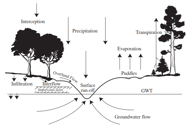
Figure 2.1. The basic components of the Run-off Cycle that contribute to the water in a pond or stream
Where there is soil, infiltrated water near the surface is subject to direct evaporation back into the atmosphere due to air currents and uptake and subsequent transpiration by surface vegetation such as grasses. If the intensity of precipitation at the soil surface is greater than the infiltration capacity of the soil, and if all the puddles have been filled, then overland flow begins. When this reaches a stream channel it becomes surface runoff. If the topography is such that the water cannot flow away in a channel, then it collects in a low point and forms a pond. Some of the water that penetrated the now-saturated soil will reach the stream channel or pond as interflow, usually where a relatively impervious layer is found close to the soil surface. The rest of the infiltrated water, which has penetrated as far as the groundwater table, eventually will also reach the stream or pond as baseflow or groundwater flow.
The water flowing in a stream or collecting in a pond is thus derived from the following sources: overland flow, interflow, groundwater flow, and direct precipitation on the water body itself. Infiltration is perhaps the single most important factor in the regulation of temporary waters, for it determines how precipitation will be partitioned into the categories of overland, inter-, and groundwater flow. Horton (1933) defined infiltration capacity as the maximum rate at which a given soil can absorb precipitation in a given condition. In the initial phase of infiltration the attraction of water by capillary forces of the soil is of great importance, although the effect of these forces in medium- to coarse-grained soils is only minor after the infiltration front has penetrated more than a metre or so. These capillary forces are greatest within fine-grained soils which have low initial moisture (Davis and DeWeist 1966). Air trapped between the soil particles may have an effect opposite to that of soil structure as at first the infiltration rate will be slowed down, as the advancing front of infiltrating water will have a tendency to expel any air it meets and this may result in the formation of pockets of dry soil which will form barriers to water movement. However, as the front continues, some air may be dissolved and the rate of advance will speed up.
The condition of the soil, particularly its texture and structure, is also of great importance as, for example, a bare soil surface will be directly exposed to rain which will tend to compact the soil and also wash small particles into open cracks and holes. This in turn will have the effect of reducing infiltration as the rain continues, and may lead to overland flow. Conversely, a dense cover of vegetation will protect the soil surface so that compaction and the filling up of cracks will be less. Further, the roots of these plants may hold the soil open and increase the normal infiltration rate. Infiltration rate is also affected by surface crusting which may block the larger pore spaces and persist until disrupted by vegetation growth, soil fauna activity, erosion, cultivation, or freeze-thaw action. Stone cover may have positive or negative impacts on infiltration, as rocks and coarse gravel may both protect the surface from rainsplash and crusting, tending to increase infiltration rate, and reduce the surface area available for infiltration (Bull and Kirby 2002).
Taking the above factors into consideration, we could speculate that, in temperate regions, a large number of temporary streams and ponds would be supported on areas of land with clay-loam soil under heavy cultivation, where many of the large stands of trees and much of the bush have been cleared, where bare soil is more common than pasture and where wire fences are preferred to earth-bank hedgerows (Figure 2.2). Were this land to be left uncultivated it would probably support a much smaller number of permanent streams and ponds instead of a large number of temporary ones. However, such predictions may be confounded by recent evidence that shows a relationship between forest growth cycles and stream discharge. In managed forests, pre-planting drainage often results in an increase in low flows, if greater than 25% of the catchment is drained. In all but the driest years, forest growth decreases low flows, whereas clear-cutting increases low flows initially, but thereafter they decline according to the rate at which the vegetation regrows (Johnson 1998).
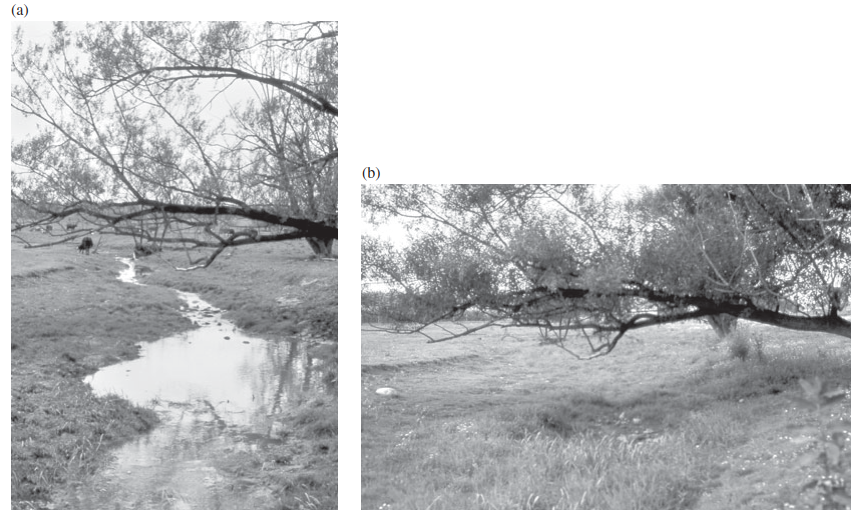
Figure 2.2. Kirkland Creek, an intermittent stream in southern Ontario, Canada during late spring (left photograph) and late summer (right photograph)
Where the soil has a high sand content, infiltration will be high and retention of water in the stream or pond bed will be influenced by the position of the groundwater table. In many arid and semi-arid regions, the water table is depressed, and this combined with low precipitation and high evaporation rates typically produces a landscape rich in temporary waters (Nanson et al. 2002). Related to the regularity of rainfall, these habitats will be either intermittent or episodic. The examples of Sycamore Creek in Arizona, and Dry Creek in Oklahoma, given in Chapter 1 (Figure 1.3), demonstrate that a range of hydrological types exists in such streams.
In the humid tropics, soils are often fully saturated for much of the year and here the lifespan of surface waters is controlled largely by evaporation, for example, around two thirds of the water which falls on the river basins of Surinam is returned back into the atmosphere (Amatali 1993). The lifespan of floodplain pools will therefore be influenced by such factors as the degree of exposure to winds and direct sunlight. For vernal forest pools in New England, Brooks and Hayashi (2002) studied predictive relationships between depth-area-volume and hydroperiod. The strongest relationship they detected was between hydroperiod and maximum pool volume, but in general, pools with a maximum depth greater than 50 cm, a maximum surface area larger than 1,000 m2, or a maximum volume greater than 100 m3 contained water on more than 80% of the occasions on which they were visited. These authors concluded that the weak relationships detected between pool morphometry and hydroperiod indicate that other factors, such as temporal patterns of precipitation and evapotranspiration and groundwater exchange, are likely to significantly influence the hydrology and hydroperiodicity of such ponds.
Date added: 2026-07-14; views: 98;