
Components of subsurface water
The factors that contribute to and influence the regime of water in temporary ponds and streams were summarized above, but what happens when the water disappears and the habitat becomes part of the terrestrial environment? This is best approached by looking at the way in which subsurface waters are classified. Figure 2.3 shows the components of subsurface water beneath a dry pond or stream bed to consist of four zones known as soil water, intermediate water, capillary water, and ground- or phreatic water. There are other zones beneath that of the groundwater, such as internal water, but they include water in unconnected pores and water in chemical combination with rocks. As the latter are beyond the access of most aquatic organisms they are largely irrelevant to the present discussion.
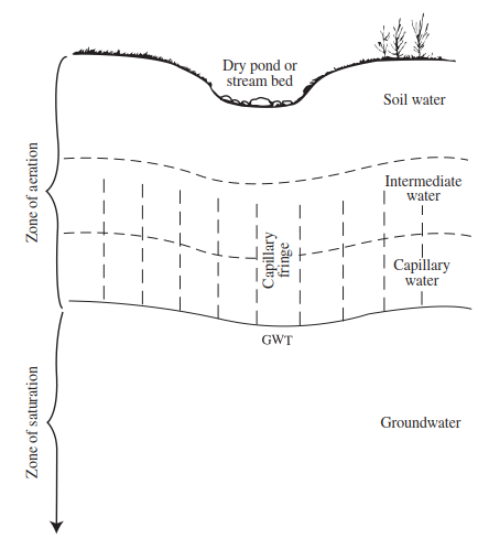
Figure 2.3. The components of subsurface water
Soil water is subject to large fluctuations in amount as a response to transpiration and direct evaporation, and it is this feature which separates it from the other unsaturated zones. The intermediate water zone lies beneath that of the soil water and separates it from the saturated zone. The water here is sometimes referred to as suspended water since although it can move downwards in response to gravity, it also can move upwards into the soil water zone should the latter become very dry. This zone is variable in size, being greatest in arid regions and absent in moist areas. The lower limit of the intermediate zone is continuous with the capillary fringe. This fringe is irregular in outline and consists of water moving up through the soil (by capillary action) from the lower parts of the capillary water zone which may be as fully saturated as the groundwater. In areas of finegrained soils, where recharge is active, the capillary fringe may extend well into the intermediate zone.
The groundwater table (GWT) separates the capillary fringe from the next water zone, the groundwater, where all the material is saturated. The GWT is commonly approximated to the level to which water will rise in a well, and it can move up or down in response to recharge. When, for example, a stream is flowing, the GWT will be near the level of the stream surface and, as it recedes, it will lower the level of the stream (or pond) unless it is offset by sudden precipitation and consequent overland flow and interflow. If it continues to recede, the stream will cease to flow and only a few pools will remain in the channel (Figure 2.4).
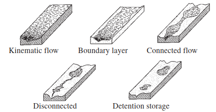
Figure 2.4. The progressive hydrological phases that occur as stream channels drain (modified from Shannon et al. 2002)
Further recession will result in disconnection of the GWT from the pools which may soon vanish due to evaporation. If the GWT remains fairly close to the ground surface, the capillary fringe may extend up to the surface of the stream or pond bed and thus provide a moist environment for those aquatic organisms that have sought refuge by burrowing. It is in situations such as this, where the GWT is close to the soil surface and soil moisture is high that a relatively small imput of moisture from rain, is sufficient to produce a substantial relaxation of moisture tension within the soil pores (Carson and Sutton 1971). The result is that the GWT may rise quickly and cause water to reappear in the pond basin. It is for this reason, too, that some temporary streams may restart for short periods after quite small amounts of rainfall.
Any further drop in the GWT will result in the setting up of the other subsurface water zones outlined above, and hence subject organisms to the large fluctuations of water content that are characteristic of the soil water zone. Deeper burrowing of active forms to reach the saturated zone, or the coordination of a special drought-resistant stage in the life cycle will be required if these taxa are to survive. In some cases, it is possible that a few species may obtain sufficient moisture from condensation of dew on the ground surface to remain in the soil water zone.
Figure 2.4 also illustrates the progressive hydrological phases that occur as ephemeral stream channels drain. Although the term 'ephemeral' was dimissed in Chapter 1 as being of limited biological use, it is, as already noted, a term still used by hydrogeologists to encompass running waters that are permanently disconnected from the GWT, for example, dryland rivers that flow only for a short period during and after rainstorms (Bull and Kirkby 2002). These phases have some relevance to the flow patterns seen in many intermittent and episodic (?unpredictably ephemeral) streams and are summarized in Table 2.1. The kinematic flow phase is seen as being relatively infrequent in dryland streams, such as those of the 'ramblas' of the Spanish Mediterranean region, but may be an annual event in temporary streams in wetter climates. Boundary layer flow, again, is commonplace in temperate and humid tropical regions. Connected flow is a very dominant phase in many temporary streams and proceeds alongside GWT recession and reduced rainfall towards disconnected flow and detention storage. Although aquatic organisms are present throughout all five phases, the latter three are often times of intense biological activity (Williams and Hynes 1976a).
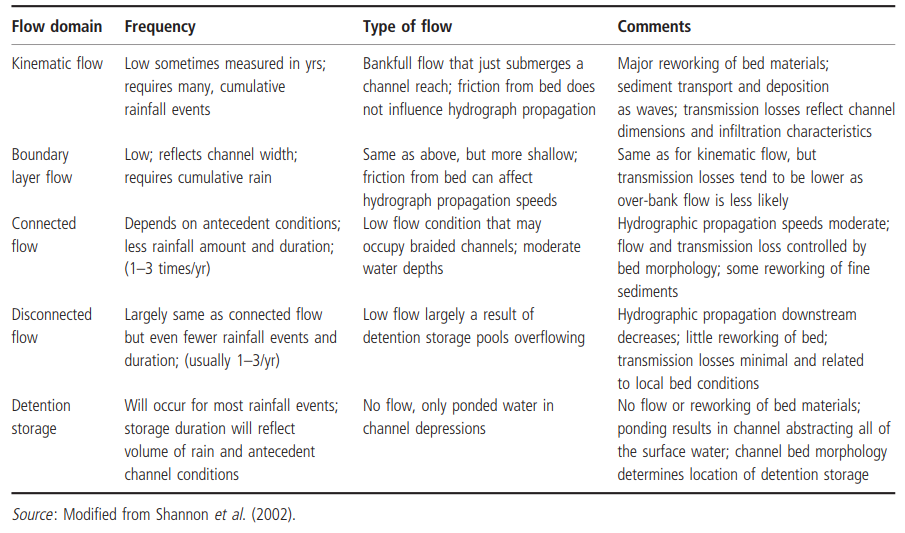
Table 2.1. Characteristics of the progressive hydrological phases of temporary streams
Details of how water begins to accumulate in a basin after drought have been provided for a Californian vernal pool (hydroperiod February to April) by Weitkamp et al. (1996). The study revealed a major relationship between water movement and basin substrate (soil) morphology. Figure 2.5(a) shows a 30-m cross-section through the pool catena, where soil depth varied from 20 cm at the summit to around 100 cm in the basin; the region is underlain by bedrock. Soil morphology varied from a weak and moderate subangular blocky structure (with <20% clay) near the summit, to strong, very coarse angular blocky structure in the basin. In addition, the latter had wedge-shaped aggregates, slickensides, and shrinkage cracks, with >40% clay.
Movement of water into the basin was followed throughout two wet seasons. After 12 mm of rainfall, infiltration occurred through the shallow upper-slope soils and flowed down towards the basin along the surface of the bedrock and within the weathered, vesicular basalt. At the footslope, further downward movement was slowed due to a marked change in soil texture. At this stage, water potentials were highest at the surface and lowest in the mid-section of the profile. They were also somewhat higher at bedrock contact points (Figure 2.5(b)) where, in a previous wet season, water was seen flowing from the soil matrix over bedrock exposed by an observation pit.
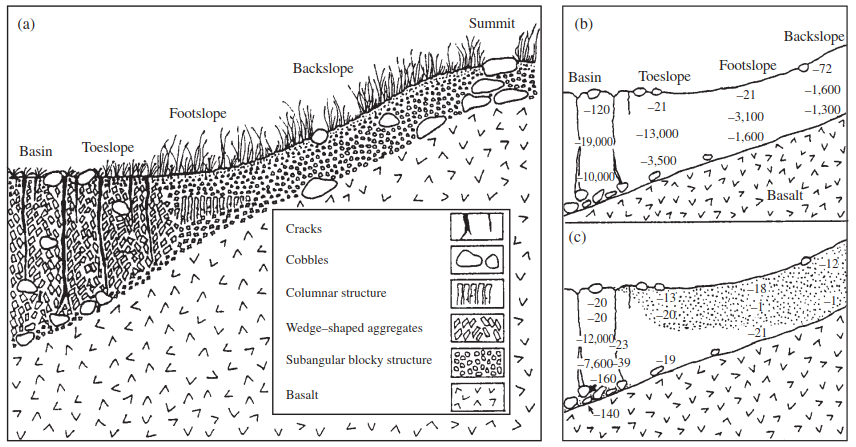
Figure 2.5. Cross sections of a vernal pool basin in southern California showing: (a) soil morphology (horizontal axis is 30 m, basin soil is ~1 m thick); (b) water potentials (in J kg-1) after 12 mm of rain; and (c) after 90 mm of rain. Stippled area indicates where free water was observed on the soil surface or in the soil matrix. Open and closed cracks are indicated in the basin soil. (redrawn from Weitkamp et al. 1996)
After 90 mm of rain, the upper 27 cm of foot- slope soil became saturated (Figure 2.5(c)) and water began to accumulate on the surface such that the perimeter of the basin exhibited standing water before the centre. Water from the ponded foot- and toe-slope soils tended to flow overland and contributed to the wetting of the basin soil. At this stage, some of the cracks in the basin vertisol (areas of dark soil rich in clay) swelled up and closed, whereas others remained open, or closed only to a depth of 5-10 cm. Later in the season, some of the cracks that were open to the basin surface filled with free water. Interestingly, in the subsurface horizon, open and closed cracks were detected as close as 15 cm to one another (indicated by the different water potentials, bottom left of Figure 2.5(c)). Such differences could be important to the survival of pond organisms seeking areas of highest substrate saturation. So, too, could Weitkamp et al.'s observation that soil materials surrounding cobbles at the bedrock contact were moister than the materials above. Upon removal of this material from the bedrock surface, via an excavated pit, water rose up from the weathered basalt.
Small temporary waters.At the microhabitat level, the hydrological characteristics of such waterbodies as rockpools, empty shells, tree holes, and 'container' habitats in general, are largely controlled by rainfall and evaporation. Typically, they will have a longer hydroperiod during wet seasons and where the effects of drying winds are minimal. There will also be some influence of basin shape; deeper bodies with restricted openings (e.g. pitcher plants and tin cans) tending to retain their water longer. In terms of phytotelmata, there will be the added factor of growing season and the availability of leaf axils and pitchers. In the case of the North American pitcher plant Sarracenia purpurea, for example, the pitchers are available for colonization only during the late spring, summer, and early autumn. In contrast, the many species within the tropical genus Nepenthes produce pitchers virtually continually, thus providing a fairly regular and somewhat more predictable supply of new habitats, within a restricted area, year round (Beaver 1983). However, even in the tropics, the flowering seasons of certain plants, for example, Heliconia, may dictate a restricted hydroperiod.
Date added: 2026-07-14; views: 119;