
Origins: basin and channel formation
Pond basins.Pond basins may be formed by natural, geological processes or by human activities. Naturally produced ponds frequently result from glacial activity, involving both erosional and depositional processes. Ice scour of flat bedrock areas typically creates basins of varying size and depth. These ponds receive all their water either directly from precipitation or by surface run-off. Other types of erosion-formed lakes and ponds are cirques, which are amphitheatre-shaped basins carved at the heads of glaciated valleys, and paternoster lakes, which are chains of ponds formed in the bottoms of these valleys. Different pond types result from the deposition of glacial debris. For example, retreating glaciers leave large deposits of ground moraine over wide areas. Where these overlie impermeable till, vast areas of wetlands and very shallow lakes and ponds have been created. Similarly, kettle ponds have been left in many areas by the melting of ice masses buried in the moraine. Deposits left at the bottoms of valleys may confine melting ice and so form basins. Besides these ero- sionally and depositionally formed basins, glaciers produce depressions through alternate freezing and thawing of the ground surface, resulting in subsidence. Shallow arctic and antarctic ponds are formed in this way (Reid 1961). Where many of these ponds merge the result is a thermokarst lake (Rex 1961).
Solution ponds are formed in regions where soluble rock has been dissolved by water. Infiltrating surface water freshly charged with carbon dioxide (forming weak carbonic acid) is particularly effective as a solvent.
Small, deep ponds may result from plunge-pools at the base of dried-up waterfalls. Large, shallow ponds may be formed in oxbow fashion (called billabongs in Australia) in any wide valley through which a river meanders, and shallow deltaic ponds are formed by sediment deposition at a river mouth.
Percolating waters may deposit an insoluble iron-pan layer in sandy, permeable soils and above this a pond may form. There are many examples of this type of pond in Surrey, in England, as well as in Sologne, France (Bowen 1982).
Meteor impact is known to have created both large and small basins but these appear to be rare, or are perhaps rarely recognized as such.
Uprooting of trees by storms commonly creates small shallow basins that drain readily in sandy soils but which may contain water for several months in clay soils (Figure 2.6).
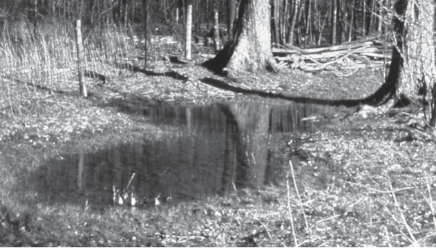
Figure 2.6. Small intermittent pool basins created by uprooted trees
Man-made basins result from industrial activities such as mining, quarrying, landscaping, etc., and also from ancient rural activities (especially in the Old World). Examples of these basins include: watering holes; peat-digging holes; moats (not just around castles, as, in the thirteenth century, moats were common features added to the houses of gentry and farmers alike, as status symbols; Taylor 1972); fish ponds (see Chapter 8); decoys (long, reed-lined, shallow channels leading from a lake and used for luring wild ducks into a trapnet); dewponds (shallow, nineteenth century, clay-lined ponds for collecting rainwater and run-off); armed ponds (watering holes with several spreading arms used for sharing water between several fields); saw pits (a practice begun in the fourteenth century, where one of two men sawing a log lengthwise stood in a pit beneath the log); charcoal pits (an ancient process producing charcoal by burning wood buried in a pit) (Rackham 1986); and temporary ponding areas created to collect sediment-laden runoff from various construction projects.
In both ancient and modern times, ponds, ditches, trenches and craters have been created during warfare. Most notably, in Vietnam's Xieng Khuang Province, the onslaught of bombs dropped continually from 1964 to 1973 has created a unique, pockmarked landscape. Bombs, each up to 900 kg, have created thousands of craters many of which are now water-filled. Some are used as fish ponds, and many dry up regularly.
How many ponds?As many temporary ponds are small they do not appear on most topographical maps, and it is therefore difficult to estimate their abundance. By careful study of fine-scale Ordnance Survey maps and applying a correction factor for small ponds (less than 6 m in diameter) not marked, Rackham (1986) estimated the total number of ponds in England and Wales to be 800,000 (or 5.4 ponds km-2) around 1880. He considered this period to have been when the total number of natural and man-made basins was at a maximum, and his estimate included both basins that were permanently and intermittently filled. The frequency of occurrence of these basins was not uniform across the country (Figure 2.7), being least dense in mountainous areas (e.g. 0.12 km-2) and most dense in areas of ancient agriculture and ancient woodlands (e.g. 115 km-2).
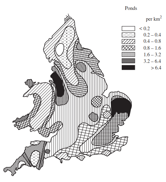
Figure 2.7. Map of England and Wales showing the distribution and approximate densities of all pond types (permanent and temporary) in the 1920s. The data were derived from fine-scale Ordinance Survey maps and a correction factor for ponds smaller than 6 m in diameter has been applied (redrawn from Rackham 1986).
Undoubtedly, this analysis will have missed many of the smallest temporary pond basins and so the nineteenth century total for England and Wales may well have peaked at more than one million. In a more recent survey, Everard et al. (1999) have estimated the number of ponds, of all sorts, in England and Wales to be between 650,000 and 750,000. Further, data from a Countryside Survey in 1996, in which temporary ponds were, for the first time, identified as a separate habitat type, showed that almost 40% of all ponds in lowland Britain were temporary; more than 82,000 in total, and representing a density of around 0.7ponds km~2 (Biggs et al. 1996; Williams et al. 2001).
Stream and river channels.Most river valleys and stream channels are formed by erosion, so the processes of formation are much less diverse than for pond basins. However, in their lower reaches these channels become much modified by depositional processes that may create a variety of features (e.g. meanders, braided channels, and deltas) some of which are associated with intermittent water residency.
Intermittency in general, however, is considered to be more a characteristic of small headwater or tributary streams. Nevertheless, many large rivers can also become dry, for example, all of the 12 major rivers that flow through northwestern Namibia (some with catchments over 400 km long) are dry, sandy channels for much of each year (Jacobson et al. 1995). Similarly, rivers in most of the world's drylands are subject to prolonged drought, for example on the west coasts of Southern Hemisphere continents (Australia, South America, southern Africa), the deserts of the American southwest, central Eurasia, and the Tibetan plateau (Nanson et al. 2002).
Irrigation ditches represent man-made temporary streams and their frequency varies according to regional agricultural practices, soil characteristics, and climate. Other examples include spillways and fish migration bypass channels that may hold water only at certain times of the year.
How many streams?Temporary streams are sometimes marked on fine- scale topographical maps as broken lines surrounded by symbols indicating a bog or marsh. In contrast to the many inventories made of permanent running waters, very few have been done for temporary ones. However, a preliminary survey (Table 2.2) of some randomly selected 1: 50,000 topographical maps of mixed rural and woodland areas in southern and central Ontario, Canada, shows densities of intermittent streams ranging from 43 to 582 per 540 km2 (0.08 to 1.08 km-2).
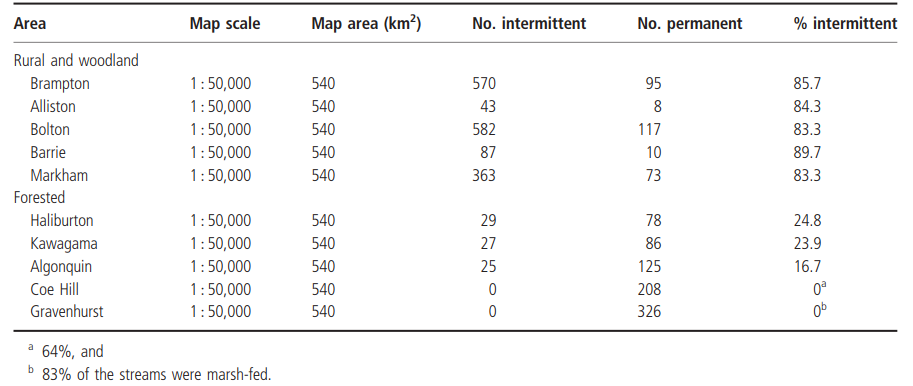
Table 2.2. Frequency of occurrence of intermittent streams in southern and central Ontario, Canada
On average, 85.3% of all first-order streams shown on these maps were marked as being intermittent at their source. This value dropped to 21.8% in more heavily wooded areas. Regions differing in geomorphology and precipitation pattern would naturally deviate from these estimates, but these figures may serve as a useful snapshot.
Date added: 2026-07-14; views: 104;